

Georgia road map
Georgia highway map
15 Interstate routes run about 1,230 miles in Georgia, each on a sheet of its own. The sheet's index lists 65 highways; I-75, I-20 and I-16 cross the most grid squares. Towns on it: Atlanta, Columbus and South Fulton.
Open the map (PDF, US Letter)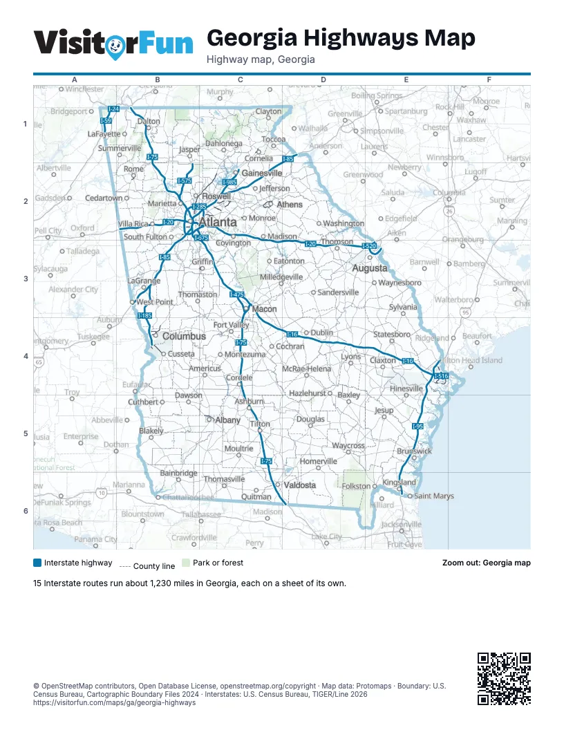
Road maps of Georgia
13 road maps: each Interstate and byway on a sheet of its own.
Highway index of Georgia
Each highway on the sheet and the grid squares it crosses.
- I-16C3, C4, D4, E4
- I-20B2, C2, C3, D3, E3
- I-24A1
- I-59A1
- I-75B1, B2, C3, C4, C5, C6, D6
- I-85B2, B3, C2, D1
- I-95E4, E5, E6
- I-185B3, B4
- I-285B2, C2
- I-475C3
- I-516E4
- I-520E3
- I-575B2
- I-675B2, C2, C3
- I-985C2
- US 17E4
- US 19B2, C2, C3, C5
- US 23C1, C2
- US 27B2, B4, B6
- US 29B2, C2
- US 41C3, C6
- US 78C2
- US 80B4, E4
- US 82C5
- US 84B6
- US 129C2
- US 278C2
- US 280B4
- US 411B2
- US 441C1, C2
- GA 1B2, B4, B6
- GA 3C3, C5
- GA 5B2
- GA 7C6
- GA 8C2
- GA 10C2
- GA 12C2
- GA 13B2
- GA 14B2
- GA 15C1, C2
- GA 17E4
- GA 20B2
- GA 21E4
- GA 22B4
- GA 25E4
- GA 26E4
- GA 28E3
- GA 38B6
- GA 53B2
- GA 85B4
- GA 133C5
- GA 140B2
- GA 141C2
- GA 154B2
- GA 166B2
- GA 204E4
- GA 232E3
- GA 300C5
- GA 316C2
- GA 365C1, C2
- GA 400B2, C2
- GA 404E4
- GA 410C2
- GA 520B4, C5
- GA 540B4, C3, C4
Places on the map
- Albany
- Americus
- Ashburn
- Athens
- Atlanta
- Augusta
- Bainbridge
- Baxley
- Blakely
- Brunswick
- Cedartown
- Claxton
- Clayton
- Cochran
- Columbus
- Cordele
- Cornelia
- Covington
- Cusseta
- Cuthbert
- Dahlonega
- Dalton
- Dawson
- Douglas
- Dublin
- Eatonton
- Folkston
- Fort Valley
- Gainesville
- Griffin
- Hazlehurst
- Hinesville
- Homerville
- Jasper
- Jefferson
- Jesup
- Kingsland
- LaFayette
- LaGrange
- Lyons
- Macon
- Madison
- Marietta
- McRae-Helena
- Milledgeville
- Monroe
- Montezuma
- Moultrie
- Quitman
- Rome
- Roswell
- Saint Marys
- Sandersville
- South Fulton
- Statesboro
- Summerville
- Sylvania
- Thomaston
- Thomasville
- Thomson
- Tifton
- Toccoa
- Valdosta
- Villa Rica
- Washington
- Waycross
- Waynesboro
- West Point
© OpenStreetMap contributors, Open Database License, openstreetmap.org/copyright · Map data: Protomaps · Boundary: U.S. Census Bureau, Cartographic Boundary Files 2024 · Interstates: U.S. Census Bureau, TIGER/Line 2026