

Missouri road map
I-35 in Missouri map
I-35 is about 112 miles in Missouri. It has 54 exits, from Exit 235 at mile 0 to Exit 114 at mile 112. It meets 20 highways; US 69, I-670 and I-70 meet it in the most grid squares.
Open the map (PDF, US Letter)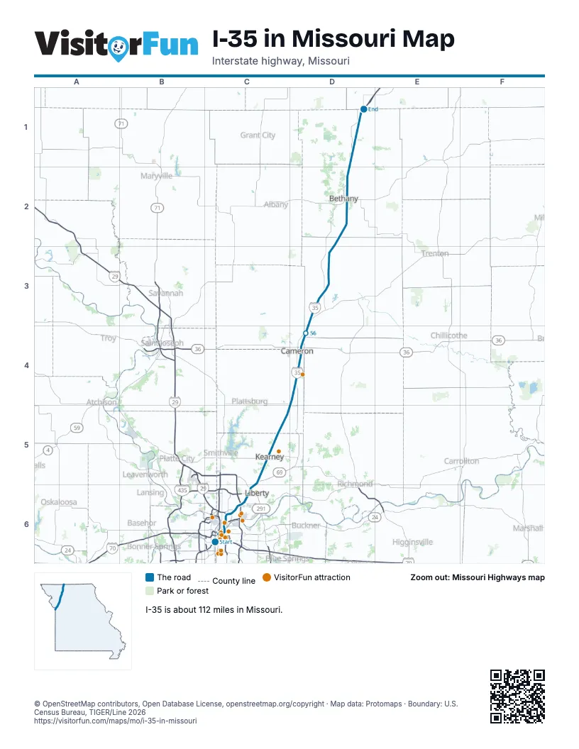
Exits on I-35 in Missouri
Each exit in mile order, with its grid square.
- Exit 235mile 0, C6
- Exit 1Bmile 1, C6
- Exit 1Cmile 1, C6
- Exit 1Dmile 1, C6
- Exit 2Umile 2, C6
- Exit 2Vmile 2, C6
- Exit 2Rmile 2, C6
- Exit 2Tmile 2, C6
- Exit 2Smile 2, C6
- Exit 2Emile 3, C6
- Exit 2Fmile 3, C6
- Exit 2G-Hmile 3, C6
- Exit 2Hmile 3, C6
- Exit 4Amile 3, C6
- Exit 4mile 4, C6
- Exit 4Bmile 4, C6
- Exit 5Amile 4, C6
- Exit 5mile 5, C6
- Exit 5Bmile 5, C6
- Exit 6mile 5, C6
- Exit 8Amile 7, C6
- Exit 8Bmile 7, C6
- Exit 8Cmile 8, C6
- Exit 9mile 8, C6
- Exit 10mile 9, C6
- Exit 11mile 10, C6
- Exit 12Amile 11, C6
- Exit 12Bmile 12, C6
- Exit 12mile 12, C6
- Exit 13mile 12, C6
- Exit 14mile 13, C6
- Exit 16mile 15, C6
- Exit 17mile 17, C6
- Exit 20mile 18, C5
- Exit 25mile 24, C5
- Exit 26mile 24, C5
- Exit 33mile 31, C5
- Exit 40mile 38, D5
- Exit 48mile 46, D4
- Exit 52mile 51, D4
- Exit 54mile 52, D4
- Exit 61mile 60, D3
- Exit 64mile 64, D3
- Exit 68mile 67, D3
- Exit 72mile 71, D3
- Exit 78mile 76, D3
- Exit 80mile 79, D2
- Exit 84mile 82, D2
- Exit 88mile 87, D2
- Exit 92mile 91, D2
- Exit 93mile 91, D2
- Exit 99mile 98, D1
- Exit 106mile 104, D1
- Exit 114mile 112, D1
Highways I-35 meets
Each highway it meets and the grid squares where they meet.
- I-670C6
- I-70C6
- US 24C6
- US 40C6
- MO 9C6
- I-29C6
- US 71C6
- MO 210C6
- MO 1C6
- US 69C6, D1, D3, D4
- I-435C6
- MO 291C6
- MO 33C5
- MO 92C5
- MO 116D5
- MO 121D4
- US 36D4
- MO 6D3
- MO 13D2
- US 136D2
Towns along I-35 in Missouri
In mile order, with the grid square of each.
- Kansas Citymile 0, C6
- North Kansas Citymile 3, C6
- Avondalemile 6, C6
- Gladstonemile 10, C6
- Claycomomile 11, C6
- Pleasant Valleymile 12, C6
- Libertymile 12, C6
- Glenairemile 13, C6
- Kearneymile 21, C5
- Holtmile 30, C5
- Lake Arrowheadmile 33, C5
- Lathropmile 38, D5
- Cameronmile 50, D4
- Winstonmile 61, D3
- Lake Vikingmile 68, D3
- Pattonsburgmile 76, D3
- Bethanymile 90, D2
- Eaglevillemile 104, D1
Things to do on the I-35 in Missouri map
- Boulevard Brewing Co. Tours & Rec Deck
- The Money Museum at the Federal Reserve Bank of Kansas City
- Crown Center
- Legoland Discovery Center Kansas City
- National WWI Museum and Memorial
- Union Station Kansas City
- Kauffman Center for the Performing Arts
- Kansas City Power & Light District
- KC Streetcar
- College Basketball Experience
- KC Visitor Center
- Just One Day Travel Tours
- Kansas City Helicopter Tours
- TerraVox Winery
- City Market
- Arabia Steamboat Museum
© OpenStreetMap contributors, Open Database License, openstreetmap.org/copyright · Map data: Protomaps · Boundary: U.S. Census Bureau, TIGER/Line 2026