

Illinois road map
I-294 in Illinois map
I-294 is about 51 miles in Illinois. It has 53 exits, from Exit 161 at mile 0 to Exit 25A at mile 51. It meets 28 highways; I-94, US 12 and US 20 meet it in the most grid squares.
Open the map (PDF, US Letter)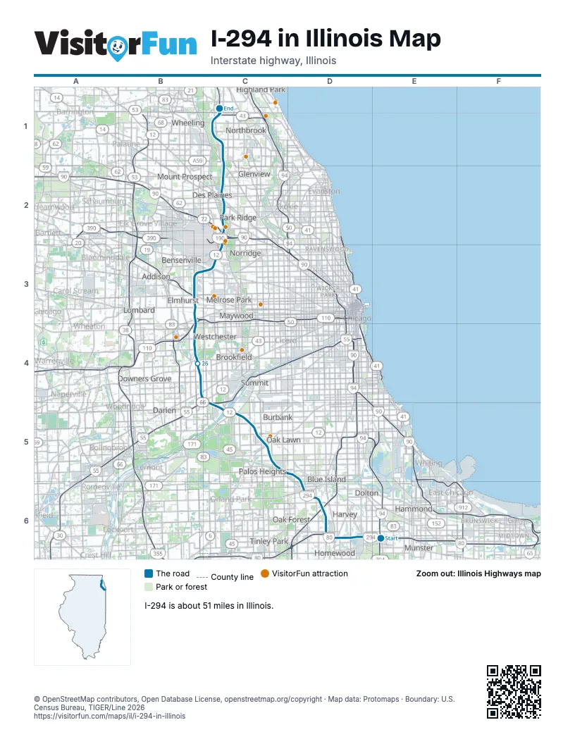
Exits on I-294 in Illinois
Each exit in mile order, with its grid square.
- Exit 161mile 0, E6
- Exit 0mile 1, D6
- Exit 2A-Bmile 2, D6
- Exit 2B-Amile 3, D6
- Exit 5, I 294 North - Wisconsin/I -80 West - Iowamile 4, D6
- Exit 6A-Bmile 6, D6
- Exit 6B-Amile 7, D6
- Exit 7mile 7, D6
- Exit 7B-Amile 8, D6
- Exit 8mile 8, D6
- Exit 12Amile 11, D5
- Exit 12Bmile 11, D5
- Exit 12 B-Amile 12, C5
- Exit 17mile 16, C5
- Exit 17Amile 17, C5
- Exit 17Bmile 17, C5
- Exit 22mile 21, C5
- Exit 23Amile 22, C5
- Exit 23Bmile 22, C5
- Exit 277Bmile 22, C5
- Exit 27Amile 26, B4
- Exit 27Bmile 27, B4
- Exit 29mile 28, B4
- Exit 30Amile 29, B4
- Exit 30Bmile 29, B4
- Exit 31mile 30, B3
- Exit 31Amile 30, B3
- Exit 31Bmile 31, B3
- Exit 15Amile 31, B3
- Exit 14mile 31, B3
- Exit 14Bmile 31, B3
- Exit 14Amile 32, B3
- Exit 13Amile 32, B3
- Exit 33mile 32, B3
- Exit 13Bmile 32, B3
- Exit 34mile 33, B3
- Exit 38B–Amile 38, C3
- Exit 39mile 38, C3
- Exit 40mile 38, C3
- Exit 1Cmile 39, C2
- Exit 1Bmile 39, C2
- Exit 1Dmile 39, C2
- Exit 40Amile 39, C2
- Exit 77Bmile 39, C2
- Exit 40Bmile 40, C2
- Exit 42 A-Bmile 40, C2
- Exit 44Amile 42, C2
- Exit 44Bmile 43, C2
- Exit 45mile 44, C2
- Exit 48mile 48, C1
- Exit 52mile 51, C1
- Exit 24mile 51, C1
- Exit 25Amile 51, C1
Highways I-294 meets
Each highway it meets and the grid squares where they meet.
- I-94C1, E6
- I-80E6
- IL 1D6
- US 6D6
- I-57D6
- IL 83D6
- IL 50D5
- IL 43C5
- US 12C3, C5
- US 20B3, C5
- IL 171C5
- US 45C3, C5
- I-55C5
- US 34B4
- IL 38B4
- I-88B3
- I-290B3
- IL 5B3
- IL 56B3
- IL 64B3
- IL 19C3
- I-190C2
- I-90C2
- IL 72C2
- US 14C2
- IL 58C2
- IL 21C1
- IL 68C1
Towns along I-294 in Illinois
In mile order, with the grid square of each.
- South Hollandmile 0, E6
- Thorntonmile 1, D6
- East Hazel Crestmile 3, D6
- Harveymile 3, D6
- Homewoodmile 3, D6
- Markhammile 4, D6
- Hazel Crestmile 4, D6
- Dixmoormile 7, D6
- Posenmile 8, D6
- Midlothianmile 8, D6
- Blue Islandmile 9, D6
- Robbinsmile 9, D6
- Crestwoodmile 9, D6
- Alsipmile 10, D6
- Palos Heightsmile 13, C5
- Oak Lawnmile 13, C5
- Worthmile 14, C5
- Chicago Ridgemile 14, C5
- Palos Hillsmile 15, C5
- Bridgeviewmile 16, C5
- Hickory Hillsmile 17, C5
- Burbankmile 17, C5
- Justicemile 19, C5
- Willow Springsmile 20, C5
- Bedford Parkmile 20, C5
- Hodgkinsmile 20, C5
- Countrysidemile 21, C5
- Burr Ridgemile 22, C5
- Indian Head Parkmile 23, C4
- Willowbrookmile 23, C4
- Western Springsmile 24, B4
- Hinsdalemile 24, B4
- Oak Brookmile 27, B4
- Westchestermile 27, B4
- Hillsidemile 28, B4
- Elmhurstmile 29, B4
- Berkeleymile 30, B3
- Melrose Parkmile 32, B3
- Northlakemile 32, B3
- Bensenvillemile 34, B3
- Franklin Parkmile 35, C3
- Chicagomile 35, C3
- Schiller Parkmile 36, C3
- Rosemontmile 38, C3
- Park Ridgemile 39, C2
- Des Plainesmile 40, C2
- Nilesmile 44, C2
- Glenviewmile 45, C2
- Prospect Heightsmile 47, C1
- Northbrookmile 47, C1
- Wheelingmile 49, C1
- Riverwoodsmile 51, C1
- Deerfieldmile 51, C1
Things to do on the I-294 in Illinois map
© OpenStreetMap contributors, Open Database License, openstreetmap.org/copyright · Map data: Protomaps · Boundary: U.S. Census Bureau, TIGER/Line 2026