

Illinois road map
Illinois highway map
23 Interstate routes run about 2,239 miles in Illinois, each on a sheet of its own. The sheet's index lists 57 highways; I-55, I-57 and IL 110 cross the most grid squares. Towns on it: Chicago, Aurora and Joliet.
Open the map (PDF, US Letter)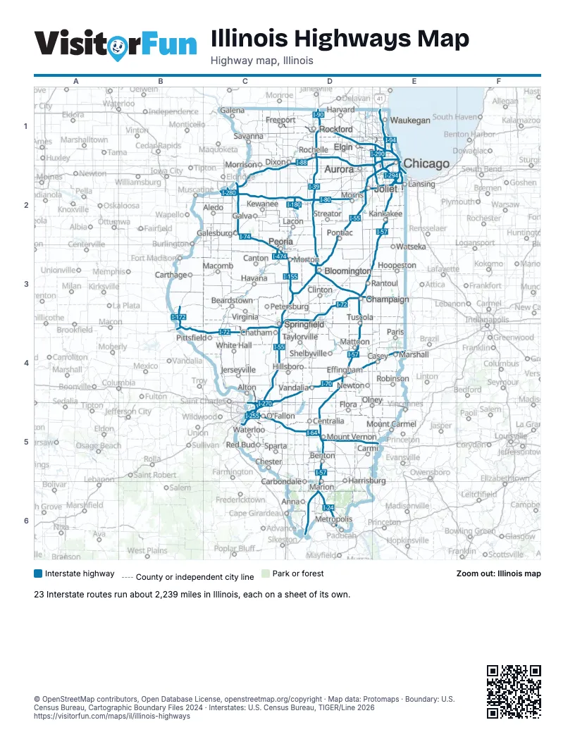
Road maps of Illinois
24 road maps: each Interstate and byway on a sheet of its own.
- I-24 in Illinois
- I-39 in Illinois
- I-55 in Illinois
- I-57 in Illinois
- I-64 in Illinois
- I-70 in Illinois
- I-72 in Illinois
- I-74 in Illinois
- I-80 in Illinois
- I-88 in Illinois
- I-90 in Illinois
- I-94 in Illinois
- I-155 in Illinois
- I-190 in Illinois
- I-255 in Illinois
- I-270 in Illinois
- I-280 in Illinois
- I-290 in Illinois
- I-294 in Illinois
- I-355 in Illinois
- I-474 in Illinois
- Illinois River Road
- Lincoln Highway
- Meeting of the Great Rivers Scenic Route
Highway index of Illinois
Each highway on the sheet and the grid squares it crosses.
- I-24D6
- I-39D1, D2, D3
- I-41E1
- I-55C3, C4, C5, D2, D3, E1, E2
- I-57D3, D4, D5, D6, E2, E3
- I-64C5, D5, E5
- I-70C4, C5, D4, E4
- I-72B4, C3, C4, D3
- I-74C2, C3, D3, E3
- I-80C2, D2, E2
- I-88C1, C2, D1, E1
- I-90D1, E1, E2
- I-94E1, E2
- I-155D3
- I-172B3, B4
- I-180D2
- I-190E1
- I-255C5
- I-270C5
- I-280C2
- I-290E1
- I-294E1, E2
- I-294EE1
- I-294WE1
- I-355E1, E2
- I-474C3
- US 6C2, E2
- US 20C1, D1, E1
- US 24C3
- US 30D2
- US 34B2, C2
- US 36B4, C3, C4, D3
- US 40C4, C5, E4
- US 41E1, E2
- US 50C5, E5
- US 51D1, D2, D3, D4, D6
- US 66C3, C4, C5, E2
- US 67C4
- IL 3C5
- IL 5C2
- IL 6C2, C3
- IL 15C5
- IL 26D2
- IL 29C3
- IL 53E1
- IL 56D1, D2
- IL 71D2
- IL 83E1, E2
- IL 92C2
- IL 104C4
- IL 110B3, B4, C1, C2, D1, E1
- IL 122D3
- IA 163B2
- IL 255C4, C5
- IL 336B3
- IL 390D1, E1
- IL 394E2
Places on the map
- Aledo
- Alton
- Anna
- Aurora
- Beardstown
- Benton
- Bloomington
- Canton
- Carbondale
- Carmi
- Carthage
- Casey
- Centralia
- Champaign
- Chatham
- Chester
- Chicago
- Clinton
- Dixon
- Effingham
- Elgin
- Flora
- Freeport
- Galena
- Galesburg
- Galva
- Harrisburg
- Harvard
- Havana
- Hillsboro
- Hoopeston
- Jerseyville
- Joliet
- Kankakee
- Kewanee
- Lacon
- Lansing
- Macomb
- Marion
- Marshall
- Mattoon
- Metropolis
- Morris
- Morrison
- Morton
- Mount Carmel
- Mount Vernon
- Newton
- O'Fallon
- Olney
- Paris
- Peoria
- Petersburg
- Pittsfield
- Pontiac
- Rantoul
- Red Bud
- Robinson
- Rochelle
- Rockford
- Savanna
- Shelbyville
- Sparta
- Springfield
- Streator
- Taylorville
- Tuscola
- Vandalia
- Virginia
- Waterloo
- Watseka
- Waukegan
- White Hall
© OpenStreetMap contributors, Open Database License, openstreetmap.org/copyright · Map data: Protomaps · Boundary: U.S. Census Bureau, Cartographic Boundary Files 2024 · Interstates: U.S. Census Bureau, TIGER/Line 2026