

Illinois road map
I-64 in Illinois map
I-64 is about 128 miles in Illinois. It has 39 exits, from Exit 40B at mile 0 to Exit 130 at mile 127. It meets 24 highways; IL 15, I-55 and US 40 meet it in the most grid squares.
Open the map (PDF, US Letter)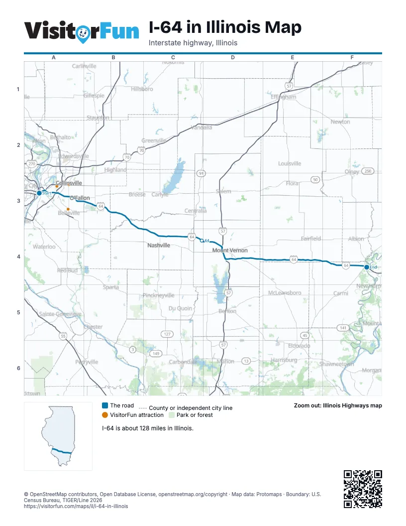
Exits on I-64 in Illinois
Each exit in mile order, with its grid square.
- Exit 40Bmile 0, A3
- Exit 1mile 0, A3
- Exit 1Bmile 1, A3
- Exit 2Amile 2, A3
- Exit 2Bmile 2, A3
- Exit 2Cmile 2, A3
- Exit 3mile 2, A3
- Exit 3Bmile 2, A3
- Exit 3Amile 2, A3
- Exit 4Amile 3, A3
- Exit 4Bmile 4, A3
- Exit 6mile 5, A3
- Exit 7mile 7, A3
- Exit 9mile 7, A3
- Exit 12mile 11, A3
- Exit 14mile 14, A3
- Exit 16mile 15, A3
- Exit 19Amile 17, A3
- Exit 19Bmile 18, B3
- Exit 21mile 20, B3
- Exit 23mile 21, B3
- Exit 27mile 26, B3
- Exit 34mile 33, B3
- Exit 41mile 39, B3
- Exit 50mile 49, C4
- Exit 61mile 59, C4
- Exit 69mile 67, D4
- Exit 73mile 71, D4
- Exit 96mile 72, D4
- Exit 95mile 73, D4
- Exit 94mile 74, D4
- Exit 92mile 76, D4
- Exit 78mile 77, D4
- Exit 80mile 77, D4
- Exit 89mile 86, D4
- Exit 100mile 97, E4
- Exit 110mile 108, E4
- Exit 117mile 114, F4
- Exit 130mile 127, F4
Highways I-64 meets
Each highway it meets and the grid squares where they meet.
- I-55A3
- US 40A3
- I-70A3
- IL 3A3
- IL 15A3, D4
- IL 111A3
- I-255A3
- US 50A3
- IL 157A3
- IL 159A3
- IL 158B3
- IL 4B3
- IL 161B3
- IL 160B3
- IL 177B3
- IL 127C4
- US 51C4
- I-57D4
- IL 148D4
- IL 37D4
- IL 142D4
- IL 242E4
- US 45E4
- IL 1F4
Towns along I-64 in Illinois
In mile order, with the grid square of each.
- Saugetmile 0, A3
- East St. Louismile 0, A3
- Fairmont Citymile 2, A3
- Madisonmile 2, A3
- Washington Parkmile 4, A3
- Cahokia Heightsmile 4, A3
- Caseyvillemile 6, A3
- Fairview Heightsmile 8, A3
- O'Fallonmile 12, A3
- Shilohmile 14, A3
- Scott AFBmile 19, B3
- Mascoutahmile 21, B3
- New Badenmile 26, B3
- Damiansvillemile 33, B3
- Okawvillemile 38, B3
- Nashvillemile 48, C4
- Richviewmile 59, C4
- Mount Vernonmile 72, D4
- Opdykemile 84, D4
- Mill Shoalsmile 108, E4
- Grayvillemile 127, F4
© OpenStreetMap contributors, Open Database License, openstreetmap.org/copyright · Map data: Protomaps · Boundary: U.S. Census Bureau, TIGER/Line 2026