

Illinois road map
Lincoln Highway map
The Lincoln Highway has been a National Scenic Byway since 2000, named for its historic qualities: about 172 miles in Illinois. It meets 32 highways, among them I-39, I-55 and I-57. Towns along it: Aurora, Joliet and Plainfield.
Open the map (PDF, US Letter)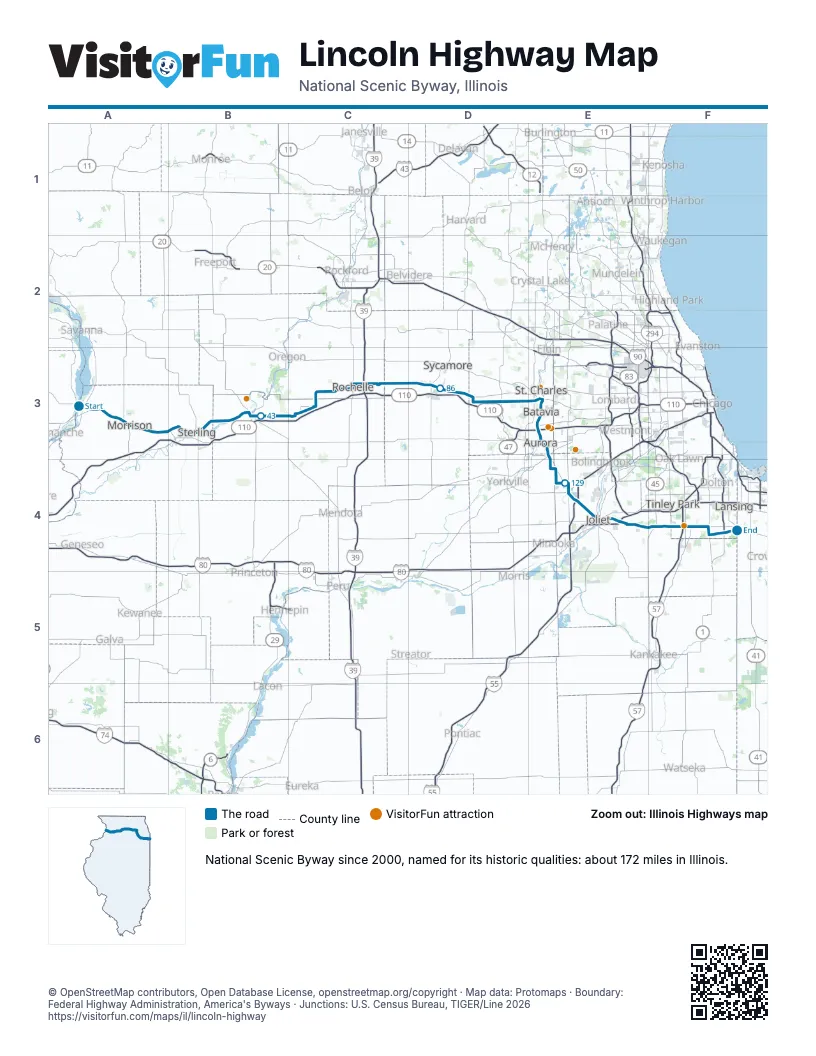
Highways it meets
Each highway it meets and the grid squares where they meet.
- IL 136A3
- IL 84A3
- US 30A3
- IL 78A3
- IL 40B3
- IL 2B3
- US 52B3
- IL 26B3
- IL 38B3
- IL 251C3
- I-39C3
- US 51C3
- IL 23D3
- IL 47D3
- IL 31E3
- I-88E3
- IL 56E3
- IL 25E3
- US 34E3
- IL 59E4
- IL 126E4
- I-55E4
- IL 7E4
- US 6E4
- IL 53E4
- I-80E4
- US 45F4
- IL 43F4
- I-57F4
- IL 50F4
- IL 1F4
- IL 394F4
Towns along the Lincoln Highway
In mile order, with the grid square of each.
- Fultonmile 0, A3
- Morrisonmile 11, A3
- Galtmile 24, B3
- Sterlingmile 25, B3
- Rock Fallsmile 25, B3
- Dixonmile 39, B3
- Franklin Grovemile 50, C3
- Ashtonmile 55, C3
- Rochellemile 63, C3
- Hillcrestmile 68, C3
- Crestonmile 71, C3
- Maltamile 77, C3
- DeKalbmile 81, D3
- Cortlandmile 87, D3
- Maple Parkmile 91, D3
- Elburnmile 100, D3
- Genevamile 105, D3
- St. Charlesmile 107, E3
- Bataviamile 108, E3
- North Auroramile 112, E3
- Auroramile 115, E3
- Montgomerymile 119, E3
- Oswegomile 120, E3
- Plainfieldmile 125, E4
- Jolietmile 133, E4
- Crystal Lawnsmile 134, E4
- Crest Hillmile 135, E4
- Sunnylandmile 135, E4
- Ridgewoodmile 142, E4
- Ingalls Parkmile 142, E4
- New Lenoxmile 143, E4
- Mokenamile 148, E4
- Frankfortmile 150, E4
- Frankfort Squaremile 155, F4
- Mattesonmile 156, F4
- Richton Parkmile 156, F4
- Olympia Fieldsmile 161, F4
- Park Forestmile 161, F4
- Chicago Heightsmile 163, F4
- South Chicago Heightsmile 165, F4
- Stegermile 166, F4
- Cretemile 166, F4
- Ford Heightsmile 168, F4
- Sauk Villagemile 168, F4
- Lynwoodmile 171, F4
Things to do on the Lincoln Highway map
© OpenStreetMap contributors, Open Database License, openstreetmap.org/copyright · Map data: Protomaps · Boundary: Federal Highway Administration, America's Byways · Junctions: U.S. Census Bureau, TIGER/Line 2026