

Missouri map
Marion County map
About 28,425 people live here (Census Bureau, 2024 estimate). The sheet's index lists 300 streets; Chicago-Kansas City Expressway, Avenue of the Saints and North Main Street cross the most grid squares. Things to do inside the boundary: Mark Twain Boyhood Home & Museum.
Open the map (PDF, US Letter)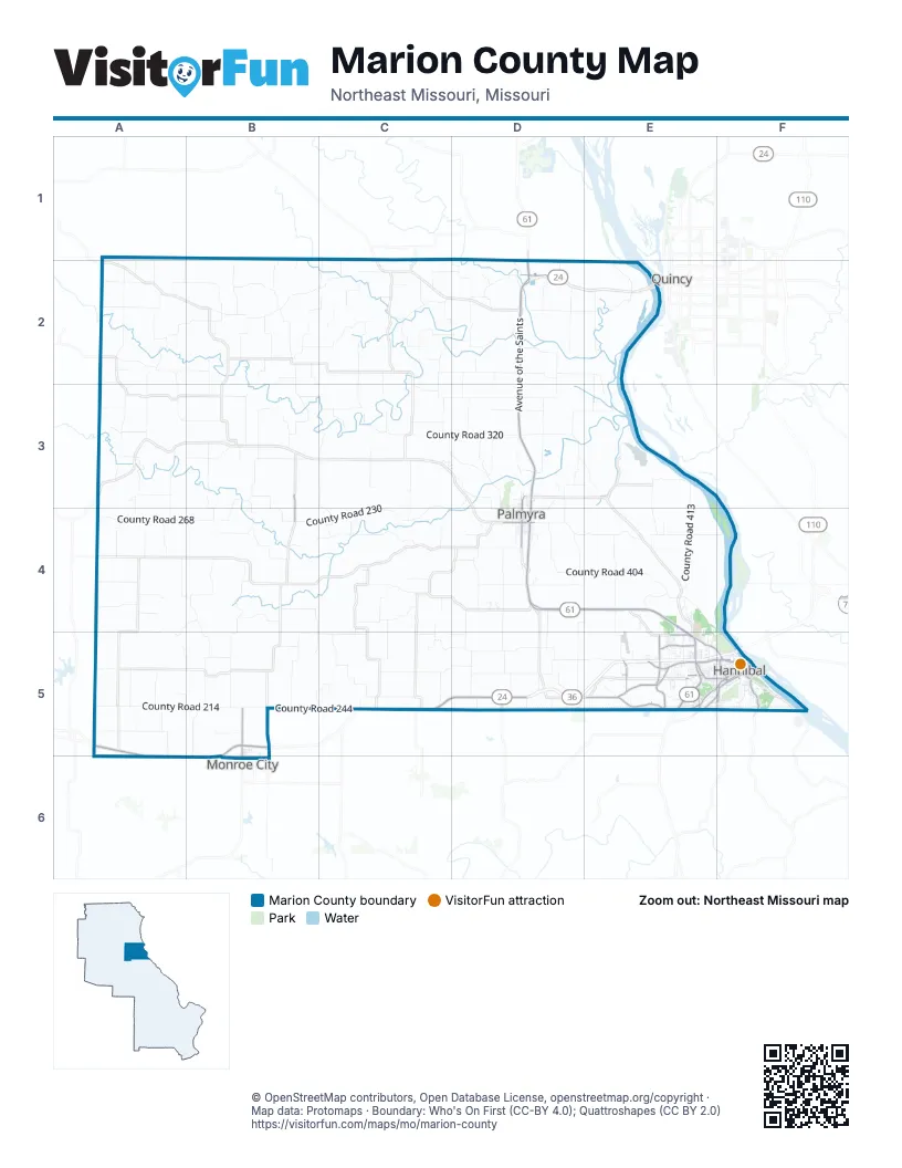
Street index of Marion County
Each street on the sheet and the grid squares it crosses.
- V.F.W. Memorial HighwayD5, E5, F5
- Mark Twain Memorial BridgeF5
- Avenue of the SaintsD2, D3, D4, E4, E5
- Chicago-Kansas City ExpresswayA5, B5, C5, D5, A6, B6
- McMasters AvenueE5
- 5th StreetB6
- Stoddard StreetB6
- East Ross StreetD4
- Veterans RoadE5
- Market StreetE5, F5
- BroadwayE5, F5
- Palmyra RoadE5
- South Main StreetD4, F5
- North Main StreetD3, D4, B5, F5, B6
- Paris Gravel RoadE5
- County Road 422E5
- Grand AvenueF5
- West ToleyB3, B4
- Lyon StreetF5
- West Ross StreetD4
- Saint Marys AvenueE5
- Harrison Hill RoadE5, F5
- Mark Twain AvenueF5
- James RoadE5
- South 3rd StreetF5
- North 3rd StreetF5
- Birch StreetF5
- Centerville RoadE5
- Warren Barett DriveE5, F5
- County Road 225B5
- Stardust DriveE5
- Fulton AvenueF5
- County Road 308D2
- Pleasant StreetE5, F5
- West Ely RoadE5
- County Road 412E5
- Shinn LaneE5
- County Road 437E5
- Lindell AvenueF5
- 30th StreetE5
- East Main Cross StreetD4
- South 7th StreetF5
- East Border StreetB6
- Old 79F5
- County Road 230C3, D3, B4, C4, D4
- County Road 214A5, B5
- County Road 413E3, E4
- County Road 231A4, B4, B5
- County Road 404D4, E4
- County Road 229B4, B5
- County Road 110B2, A3
- County Road 402D4, E4
- County Road 234C4
- County Road 268A4, B4
- County Road 320C3, D3
- County Road 159B2, B3
- County Road 346D2, E2
- County Road 424D5, E5
- County Road 249C5
- County Road 329C3, D3, D4
- County Road 240B5, C5
- County Road 153C2, C3
- County Road 216A5, A6
- County Road 189B3, B4
- County Road 226B4
- County Road 103A2
- County Road 244B5, C5
- County Road 117A2, A3
- County Road 118B2, C2
- County Road 344D2, D3
- County Road 195B3, B4
- County Road 408E4, F4
- County Road 197A3, A4
- County Road 316C3, D3
- County Road 312C2, D2
- County Road 337D3
- County Road 199A3, A4
- County Road 304C2
- County Road 104A2
- County Road 407E4
- County Road 167B3
- County Road 319C2, D2, C3
- County Road 134B3, C3
- County Road 355E2
- County Road 150C2
- County Road 250C4
- County Road 218A4, A5, B5, A6
- County Road 279D4
- County Road 342D3, E3
- County Road 258D5
- County Road 262D5
- County Road 324D3, D4
- County Road 245B5
- County Road 148B3, B4
- County Road 111A2, B2
- County Road 233B4
- County Road 187C3, C4
- County Road 204A4
- County Road 130A3, B3
- County Road 173A3
- County Road 353D2
- County Road 277D4
- County Road 256C5, D5
- County Road 106A2, B2
- County Road 306D2
- County Road 183C3, C4
- County Road 238B4, B5
- County Road 410E4, F4, F5
- County Road 272C5, D5
- County Road 426D5
- County Road 361D3
- County Road 127B1, B2
- County Road 303C2, D2
- County Road 425E4, E5
- County Road 307D1, D2
- County Road 421D4, E4, D5
- County Road 135B2
- County Road 310D2
- County Road 315D2
- County Road 143C2
- County Road 403D4
- County Road 129B1, B2
- County Road 252C4
- County Road 261A1, B1, D4, D5
- 310th StreetA1, B1, C1
- County Road 332D3
- County Road 406D4
- County Road 223B5, B6
- County Road 411E3, E4
- County Road 414E5
- County Road 169B3
- County Road 131B2
- County Road 137B2
- County Road 253C4, C5
- County Road 264D4
- County Road 109A1, A2
- County Road 224B4
- County Road 357E2
- County Road 133B2
- County Road 263D5
- County Road 339D3, E3
- County Road 247B5, C5
- County Road 333D3
- County Road 122A2
- County Road 115A2
- County Road 102A2
- County Road 158C1, C2
- County Road 146A3
- County Road 171A3
- County Road 340D2, E2
- County Road 302C2, D2
- County Road 108B2
- County Road 331D3
- County Road 202A4
- County Road 405D4
- County Road 243C4
- County Road 235A4
- County Road 275D4, D5
- County Road 338D2
- County Road 266D4
- Er Map RoadB3
- County Road 132A3
- County Road 419D4, D5
- County Road 239A4
- County Road 211A5
- County Road 246C5
- County Road 325D3
- County Road 341D3
- County Road 120A2, B2
- County Road 327C3
- Bird StreetE5, F5
- County Road 336D3
- County Road 237A4
- County Road 345E2, E3
- County Road 209A5
- County Road 349D2
- County Road 265C5
- County Road 123B2, B3
- County Road 248C5
- County Road 409E4
- County Road 227B5
- County Road 343D3
- Withers Mill RoadD5
- County Road 185C3
- County Road 126A2, A3
- County Road 145C2
- County Road 221B5
- County Road 175A3
- County Road 220B5
- County Road 322C3
- Hill StreetE5, F5
- County Road 313D1, D2
- County Road 147C1, C2
- County Road 222A4, B4, A5
- County Road 318D3
- County Road 328D3, D4
- County Road 139B2, C2
- County Road 142B3
- Munger LaneE5
- County Road 163C3
- County Road 301C2
- County Road 179C3
- County Road 217A5, B5
- County Road 305C2
- County Road 191B3, B4
- County Road 206A4
- Industrial DriveD4
- Head LaneE5
- County Road 254C4
- County Road 165B2
- County Road 359E3
- County Road 314C3
- County Road 416E5
- Put RoadD4
- County Road 112C2
- County Road 157B2, B3
- County Road 107A1, A2
- County Road 208A5
- County Road 207A5
- County Road 365D2
- County Road 321D2, D3
- South Arch StreetF5
- County Road 213A5
- Hummingbird LaneE5
- County Road 323D2, D3
- County Road 401D3, D4
- County Road 334D3
- Marion City RoadD4
- County Road 141C2
- County Road 281C4
- South Home StreetD4
- County Road 212A5
- County Road 271D5
- West Line StreetD4
- County Road 160B2
- County Road 125A2, A3
- County Road 273D5
- County Road 144A3, B3
- Birch LaneD2
- Timber Ridge RoadC3
- County Road 228B4
- Country Club DriveE5
- County Road 151C2, C3
- County Road 161B3
- West New StreetD4
- Center StreetF5
- Pioneer TrailE5
- County Road 347E2, E3
- Orchard Point RoadE4, E5
- County Road 241C4
- County Road 215A5
- Church StreetF5
- County Road 420E5, F5
- Bluff StreetF5
- County Road 155C3
- South Spring StreetD4
- Ely StreetF5
- Grace StreetE5, F5
- County Road 251B5
- Clinic RoadE5
- County Road 270D4
- Bridge StreetF5
- Central AvenueE5
- County Road 154B2
- Old Highway 24D5
- County Road 105A1, A2
- County Road 140B3
- Hope StreetE5, F5
- Chestnut StreetE5, F5
- County Road 309D2
- Union StreetF5
- Gordon StreetE5, F5
- Park AvenueF5
- County Road 219B5
- North StreetF5
- Lake Apollo DriveE5
- County Road 351D2
- Rock StreetF5
- El Rancho DriveE4
- Outer RoadD2
- County Road 259C5
- North Dickerson StreetD3, D4
- County Road 274C5, D5
- County Road 177A3
- County Road 427D5
- West Church StreetD4
- County Road 114C2
- Vermont StreetF5
- County Road 311D2
- Bowling AvenueE5
- Gala DriveE5
- County Road 255C4
- South Dickerson StreetD4
- Valley StreetF5
- South Lane StreetD4
- Colfax AvenueF5
- County Road 124A2
- Marsh AvenueE5
- North Spring StreetD3, D4
- Clover RoadE5
Things to do on the Marion County map
Places on the map
- American Legion Golf Course
- Bear Creek Park
- Cardiff Hill
- Clemens Field
- College Heights
- Doctor J W Well Lake
- Doctor Wells Lake
- Dr. J.W. Well Nature Park
- Drive in Theatre site
- Dulany Park
- Flower city meadow
- Flower City Park
- Greenwood Cemetery
- Hannibal
- Hannibal Country Club
- Hannibal Post Office
- Hannibal Regional Airport
- Hannibal Regional Hospital
- Harrison Hill
- Healthy Way Trail
- Holliday Hill
- Huckleberry Park
- J. Thad Ray Memorial Wildlife Area
- Julian Steyermark Woods Conservation Area
- McKay Lake
- Mount Olivet Cemetery
- Mount Olivet Memorial Park
- Palmyra
- Riverside Cemetery
- Riverview Park
- Saint Marys Cemetery
- Sawyer's Creek Fun Park
- Sodalis Park
- Southside Recreation Park #2
- Speckhart Lake
- Submersible Earth Dike
- TNT Kartways
- Whitney Island
- Wiseman Recreation Lake
- Ziegler Island
Next to Marion County
- Monroe City
- Quincy
© OpenStreetMap contributors, Open Database License, openstreetmap.org/copyright · Map data: Protomaps · Boundary: Who's On First (CC-BY 4.0); Quattroshapes (CC BY 2.0)