

Missouri map
Northeast Missouri map
The sheet's index lists 23 highways; US 61, I-70 and US 40 cross the most grid squares. Things to do inside the boundary: Adam Puchta Winery, Anheuser-Busch Brewery Tour and Busch Stadium. Also on it: Arnold, Bowling Green and Chesterfield.
Open the map (PDF, US Letter)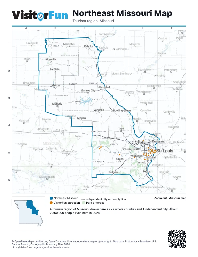
Highway index of Northeast Missouri
Each highway on the sheet and the grid squares it crosses.
- I-44D5, D6, E5
- I-55E5, E6
- I-64D5, E5
- I-70C4, D4, D5, E5
- I-72D3
- I-170E5
- I-255E5
- I-270E5
- US 24C3
- US 36B3, C3, D3
- US 40C4, D4, D5, E5
- US 50D5, E5
- US 61C2, D3, D4, D5, E5
- US 63B3
- US 66E5
- US 67E4, E5
- MO 94E5
- MO 100D5, E5
- IL 110D3
- MO 110B3, C3, D3
- MO 364E5
- MO 367E5
- MO 370E5
Things to do on the Northeast Missouri map
- Adam Puchta Winery
- Anheuser-Busch Brewery Tour
- Busch Stadium
- Busch Stadium Tours & Cardinals Hall of Fame Museum
- Cathedral Basilica of Saint Louis
- Cherokee Street
- City Museum
- Cliff Cave County Park
- Cuivre River State Park
- Delmar Loop
- Drury Plaza Hotel St. Louis Brentwood
- Fast Lane Classic Cars
- Federal Reserve Bank of St. Louis
- First Missouri State Capitol State Historic Site
- Forest Park
- Fort Belle Fontaine
- Gateway Arch National Park
- Grant's Farm
- Greater St. Charles Visitor Center
- Hermann Visitor Information Center
- Hermann Wine Trail
- Historic Main Street St. Charles
- Hollywood Casino St. Louis
- Laumeier Sculpture Park
- Long Branch State Park
- Mama's On The Hill
- Mark Twain Birthplace State Historic Site
- Mark Twain Boyhood Home & Museum
- Mark Twain State Park
- Meramec Caverns
- Mid America Adventure
- Missouri Botanical Garden
- Missouri History Museum
- National Museum of Transportation
- Plaza Frontenac
- Residence Inn St. Louis Downtown
- River City Casino & Hotel
- Riverboats at the Gateway Arch
- Saint Louis Art Museum
- Saint Louis Car Museum
- Saint Louis Galleria
- Saint Louis Science Center
- Saint Louis Zoo
- Soulard Farmers Market
- South County Antique Mall
- St. Louis Aquarium at Union Station
- St. Louis Central Library
- Ted Drewes Frozen Custard
- The Fabulous Fox Theatre
- The Hill
- The Magic House, St. Louis Children's Museum
- The Muny
- Ulysses S. Grant National Historic Site
- Wakonda State Park
- Washington Visitor Center
- West County Center
- World Chess Hall of Fame
- WOW Entertainment
Places on the map
- Arnold
- Bowling Green
- Chesterfield
- Festus
- Florissant
- Hannibal
- Kahoka
- Kirksville
- La Plata
- Macon
- Memphis
- Mexico
- Moberly
- Monroe City
- O'Fallon
- Oakville
- St. Louis
- Sullivan
- Troy
- Union
- Vandalia
- Warrenton
- Wildwood
Next to Northeast Missouri
- Storied and Scenic
- Great Rivers Country
- Central Missouri map
- Northwest Missouri map
- Southeast Missouri map
© OpenStreetMap contributors, Open Database License, openstreetmap.org/copyright · Map data: Protomaps · Boundary: U.S. Census Bureau, Cartographic Boundary Files 2024