

New Jersey map
Union City map
About 66,918 people live here (Census Bureau, 2024 estimate). The sheet's index lists 96 streets; Bergenline Avenue, New York Avenue and Palisade Avenue cross the most grid squares. Also on it: afc Urgent Care, Alexa Mini Market and American War Memorial Plaza.
Open the map (PDF, US Letter)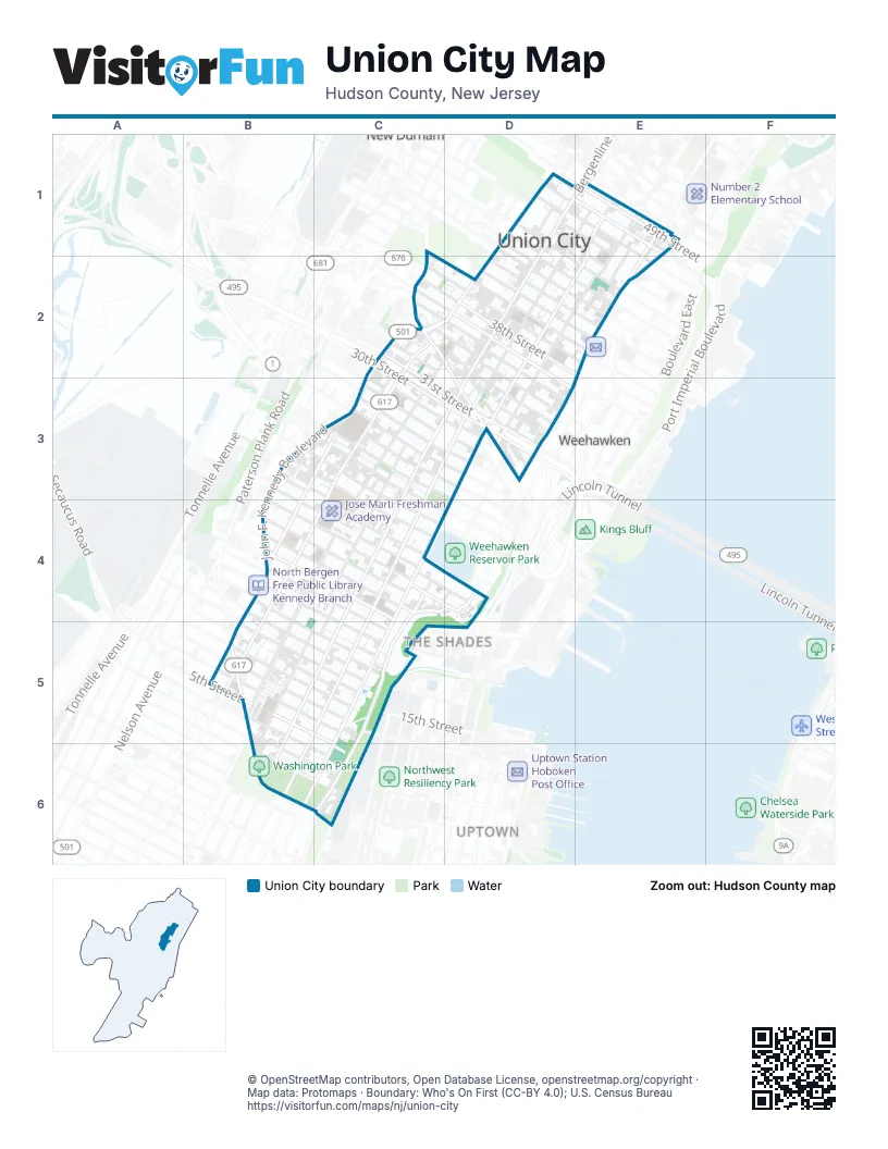
Street index of Union City
Each street on the sheet and the grid squares it crosses.
- 43rd StreetD1, D2, E2
- 44th StreetD1, D2, E2
- 45th StreetD1, E2
- 46th StreetD1, E1, E2
- 47th StreetD1, E1, E2
- 48th StreetD1, E1
- 49th StreetD1, E1
- Bergenline AvenueD1, E1, D2, C3, D3, C4, B5, C5, B6
- Cottage PlaceD1
- Golden LaneD1
- Harrison PlaceD1
- John F. Kennedy BoulevardD1, C2, D2, B3, C3, B4, B5
- Lincoln StreetD1, D2
- New York AvenueD1, E1, D2, C3, D3, C4, B5, C5, B6
- BroadwayE1, E2
- Brown StreetE1, E2
- Hudson AvenueE1, D2, E2, D3
- Palisade AvenueE1, D2, E2, D3, C4, D4, C5, B6, C6
- Park AvenueE1, E2, D3, E3
- Roosevelt StreetE1, E2
- 30th StreetC2, C3, D3
- 31st StreetC2, C3, D3
- 32nd StreetC2, D2, D3
- 35th StreetC2, D2, D3
- 36th StreetC2, D2, D3
- 37th StreetC2, D2, D3
- 38th StreetC2, D2, E2
- 39th StreetC2, D2, E2
- Bergen TurnpikeC2
- Central AvenueC2, D2, C3, B4, C4, B5
- Henry StreetC2
- Jeanette StreetC2, C3
- Sip StreetC2
- Summit AvenueC2, C3, B4, C4, B5
- 33rd StreetD2, D3
- 34th StreetD2, D3
- 40th StreetD2, E2
- 41st StreetD2
- 42nd StreetD2, E2
- Columbia TerraceE2
- Fulton StreetE2
- 19th StreetB3, B4, C4, D4
- 20th StreetB3, C3, C4, D4
- 21st StreetB3, C3, C4
- 22nd StreetB3, C3, C4
- Kerrigan AvenueB3, C3, B4
- 23rd StreetC3, C4, D4
- 24th StreetC3, D3
- 25th StreetC3, D3
- 26th StreetC3, D3
- 27th StreetC3, D3
- 28th StreetC3, D3
- 29th StreetC3, D3
- Adam PlaceC3
- West StreetC3, C4, B5
- Angelique StreetD3
- Cantello StreetD3
- Dodd StreetD3
- Highwood TerraceD3
- Jane StreetD3
- Jefferson StreetD3
- Maple StreetD3
- North Marginal HighwayD3
- Peter StreetD3
- Plank RoadD3
- Pleasant AvenueD3
- Ridgeley PlaceD3
- Shippen StreetD3
- South Marginal HighwayD3
- 12th StreetB4, B5, C5
- 13th StreetB4, C4, C5
- 14th StreetB4, C4, C5
- 15th StreetB4, C4
- 16th StreetB4, C4
- 17th StreetB4, C4
- 18th StreetB4, C4, D4
- Cliff StreetC4, D4
- Highpoint AvenueC4
- Manhattan AvenueC4, C5, C6
- Monastery PlaceC4
- Morris StreetC4, C5
- Mountain RoadC4, D4
- Saint Michaels WalkC4
- Oak StreetD4
- 10th StreetB5, C5
- 11th StreetB5, C5
- 3rd StreetB5, B6, C6
- 4th StreetB5, B6, C6
- 5th StreetB5, C6
- 6th StreetB5, C5
- 7th StreetB5, C5
- 8th StreetB5, C5
- 9th StreetB5, C5
- Paterson Plank RoadB5, B6, C6
- Tournade PlaceC5
- 2nd StreetB6, C6
Places on the map
- afc Urgent Care
- Alexa Mini Market
- American War Memorial Plaza
- Bank of America
- Bruce D. Walter Recreation Center
- Church of San Lazaro
- Colin Powell Elementary School
- Elsworth Park
- Emanuel United Methodist Church
- Emerson High School
- Evangelical Pentecostal Church
- Exxon
- fancy dry cleaners
- Farmacia latina/ nail salon
- Fine Fair
- Firefighters' Memorial Park
- GoPuff
- Grace Episcopal Church
- Holy Cross Armenian Church
- Holy Family Church
- Holy Family School
- Hudson Korean Presbyterian Church
- Iglesia Cristiana Pentecostal
- Iglesia Metodista Unida
- Jefferson Elementary School
- Jose Marti Field
- Jose Marti Freshman Academy
- Jose Marti Recreational Ground
- Jose Marti Soccer and Recreational Ground
- Julys best groomer
- KFC
- La Roca
- Las Buenas Nuevas
- Lasorpresa
- Leber Funeral Home
- Lukoil
- Washington Park
Next to Union City
- Lincoln Harbor
- New Durham
- The Shades
- Uptown
- Weehawken
© OpenStreetMap contributors, Open Database License, openstreetmap.org/copyright · Map data: Protomaps · Boundary: Who's On First (CC-BY 4.0); U.S. Census Bureau