

New Jersey map
Hudson County map
About 736,185 people live here (Census Bureau, 2024 estimate). The sheet's index lists 263 streets; John F. Kennedy Boulevard, Palisade Avenue and Tonnelle Avenue cross the most grid squares. Things to do inside the boundary: Liberty Science Center, Liberty State Park and Wyndham Garden North Bergen Near Secaucus.
Open the map (PDF, US Letter)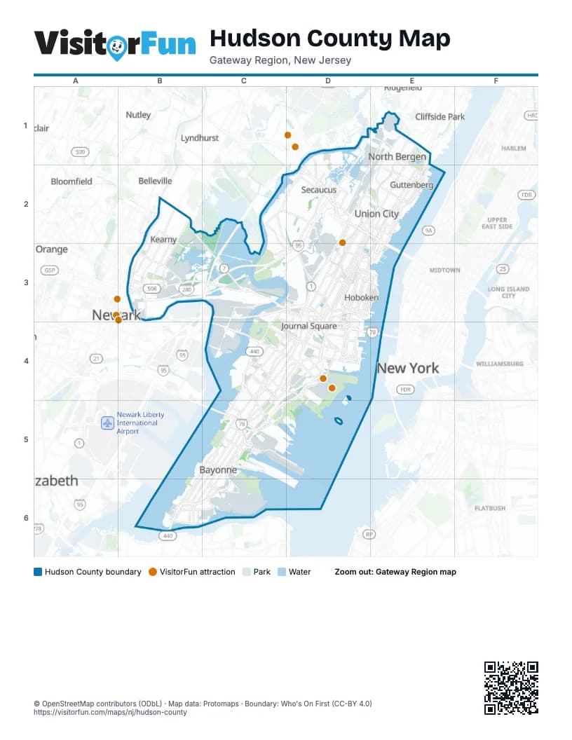
Maps inside Hudson County
1 map inside, from the street map of Hudson County down.
Street index of Hudson County
Each street on the sheet and the grid squares it crosses.
- New Jersey Turnpike Eastern SpurD1, D2, C3, D3
- Paterson Plank RoadD1, D2, D3
- 75th StreetE1
- 76th StreetE1, E2
- 79th StreetE1, E2
- 83rd StreetE1
- 91st StreetE1
- 92nd StreetE1
- Anderson AvenueE1
- Bergen BoulevardE1
- Bergenline AvenueE1, D2, E2, D3
- Bergenwood AvenueE1
- Bergenwood RoadE1
- Boulevard EastE1, E2, E3
- Cottage AvenueE1
- Fairview AvenueE1
- John F. Kennedy BoulevardE1, D2, E2, D3, C4, D4, C5, B6
- Palisade AvenueE1, D2, E2, D3, D4
- Park DriveE1
- River RoadE1, E2
- Tonnelle AvenueE1, D2, E2, D3, D4
- Wall StreetE1
- West Side AvenueE1, D2, D3, C4, D4
- Woodcliff AvenueE1
- Belgrove DriveB2, B3
- Belleville TurnpikeB2, C3
- Davis AvenueB2, B3
- Kearny AvenueB2, B3
- Midland AvenueB2
- Passaic AvenueB2, B3
- Schuyler AvenueB2, B3
- Castle RoadC2, C3, D3
- Meadowlands ParkwayC2, D2
- New Jersey Turnpike Western SpurC2, C3
- Seaview DriveC2, D2, D3
- Secaucus RoadC2, D2, D3
- 10th StreetD2
- 30th StreetD2
- 31st StreetD2, E2
- 32nd StreetD2, E2
- 37th StreetD2, E2
- 38th StreetD2, E2
- 51st StreetD2, E2
- Bergen TurnpikeD2
- Columbia AvenueD2
- County AvenueD2, D3
- Front StreetD2
- Harmon Meadow BoulevardD2
- Harmon PlazaD2
- John F Kennedy BoulevardD2, B6
- Kerrigan AvenueD2, D3
- Mill Creek DriveD2
- New York AvenueD2, D3
- Old Route 3D2
- Park Plaza DriveD2
- Plaza CenterD2
- Plaza DriveD2
- Radio AvenueD2
- South Marginal HighwayD2, E2
- Summit AvenueD2, D3, D4
- Union TurnpikeD2
- 48th StreetE2
- 49th StreetE2
- 60th StreetE2
- 61st StreetE2
- 69th StreetE2
- 70th StreetE2
- 74th StreetE2
- BroadwayE2, C3, D3, C5, B6
- Bulls Ferry RoadE2
- Cantello StreetE2
- Carlyle CourtE2
- Clifton TerraceE2
- Ferry RoadE2
- Granton AvenueE2
- Gregory AvenueE2, D3, E3
- Hackensack AvenueE2, D3, E3
- Highwood AvenueE2
- Highwood TerraceE2
- Hillside RoadE2
- Hudson AvenueE2
- Lincoln TunnelE2, E3
- North Marginal HighwayE2
- Park AvenueE2, D3, E3
- Pershing RoadE2
- Plank RoadE2
- Pleasant AvenueE2
- Port Imperial BoulevardE2, E3
- Bergen AvenueB3, C4, D4
- Bergen StreetB3
- Bridge StreetB3
- Central AvenueB3, C3, D3, C4
- Clay StreetB3
- Economy Supply WayB3
- Essex FreewayB3, C3
- Essex StreetB3
- Frank E Rodgers Boulevard SouthB3
- Frank E. Rodgers BoulevardB3
- Frank E. Rodgers Boulevard NorthB3
- Frank E. Rodgers Boulevard SouthB3
- Hamilton StreetB3
- Harrison AvenueB3
- Jackson StreetB3, D3
- Newark-Jersey City TurnpikeB3, C3
- North 2nd StreetB3
- Fish House RoadC3
- New Wittpenn BridgeC3
- Newark TurnpikeC3
- Paul Amico WayC3, D3
- Pennsylvania AvenueC3
- Pulaski SkywayC3, D3
- Sip AvenueC3, D4
- 11th StreetD3, E3, D4
- 12th StreetD3, E3, D4
- 14th StreetD3, E3, D4
- 15th StreetD3
- 16th StreetD3
- 18th StreetD3, D4
- 19th StreetD3, E3
- 1st StreetD3
- 20th StreetD3
- 2nd StreetD3
- 4th StreetD3, E3
- 5th StreetD3
- Adams StreetD3
- Baldwin AvenueD3, E3, D4
- Bevan StreetD3
- Bloomfield StreetD3, E3
- Clinton StreetD3
- Coles StreetD3
- Congress StreetD3
- Conrail ViaductD3
- County RoadD3
- Grand AvenueD3
- Grove StreetD3, D4
- Highpoint AvenueD3, E3
- Hoboken AvenueD3, D4
- Hudson PlaceD3
- Hudson StreetD3, E3, D4
- Jefferson StreetD3
- Jersey AvenueD3, D4
- Madison StreetD3
- Manhattan AvenueD3
- Marin BoulevardD3, D4
- Michael Pane WayD3
- Monroe StreetD3
- Mountain RoadD3
- Nelson AvenueD3
- New County RoadD3
- Newark AvenueD3, D4
- Newark StreetD3
- NJ 139 Lower LevelD3, D4
- NJ 139 Upper LevelD3
- Oakland AvenueD3
- Observer HighwayD3
- Paterson AvenueD3
- Pavonia AvenueD3, D4
- Prospect StreetD3
- Quincy StreetD3
- Ravine AvenueD3
- Reservoir AvenueD3
- River StreetD3
- Saint Paul's AvenueD3
- Saint Pauls AvenueD3
- US 1-9 TruckD3
- Washington StreetD3, E3, D4
- Webster AvenueD3
- Willow AvenueD3, E3
- Lincoln Tunnel HelixE3
- Sinatra DriveE3
- Waterfront TerraceE3
- Arlington AvenueC4, D4
- Bayview AvenueC4, D4
- Carbon PlaceC4
- Communipaw AvenueC4, D4
- Culver AvenueC4
- Danforth AvenueC4, C5
- Duncan AvenueC4, D4
- Fairmount AvenueC4, D4
- Fisk StreetC4
- Fulton AvenueC4
- Garfield AvenueC4, D4, C5
- Kellogg StreetC4
- Lincoln HighwayC4
- Long StreetC4, C5
- Mallory AvenueC4
- Martin Luther King DriveC4, D4
- Martin Luther King Jr. DriveC4
- McAdoo AvenueC4
- Motorano WayC4
- Ocean AvenueC4, D4, C5
- Old Bergen RoadC4, C5
- Stockton AvenueC4
- Woodlawn AvenueC4
- 12th Street ViaductD4
- 14th Street ViaductD4
- 8th StreetD4
- Brunswick StreetD4
- Burma RoadD4
- Caven Point AvenueD4
- Caven Point RoadD4, C5, D5
- Center StreetD4
- Christopher Columbus DriveD4
- Grand StreetD4
- Greene StreetD4
- Holland TunnelD4, E4
- Ivy PlaceD4
- Jersey City BoulevardD4
- Johnston AvenueD4
- Jordan AvenueD4
- Mall Drive EastD4
- Manila AvenueD4
- Merseles StreetD4
- Montgomery StreetD4
- Monticello AvenueD4
- Morris Pesin DriveD4
- New Jersey Turnpike Newark Bay ExtensionD4, C5, D5
- Newport ParkwayD4
- Orchard StreetD4
- Pacific AvenueD4
- Phillip StreetD4
- Thomas Gangemi DriveD4
- Washington BoulevardD4
- Wilson StreetD4
- Avenue AB5, C5, B6
- Avenue CC5, B6, C6
- Avenue EC5, B6, C6
- Centre StreetC5
- Chosin Few WayC5
- East 30th StreetC5
- East 32nd StreetC5
- East 45th StreetC5
- East 53rd StreetC5
- Goldsborough DriveC5
- Linden Avenue EastC5
- Merritt StreetC5
- Port Jersey BoulevardC5, D5
- Port Lincoln RoadC5
- Port Terminal BoulevardC5
- Princeton AvenueC5
- Prospect AvenueC5
- Pulaski Lane WestC5
- Pulaski StreetC5
- Rose AvenueC5
- West 30th StreetC5
- West 45th StreetC5
- West 53rd StreetC5
- West 63rd StreetC5
- Bayonne BridgeB6
- East 1st StreetB6
- East 5th StreetB6, C6
- Lexington AvenueB6
- North StreetB6
- West 1st StreetB6
- West 4th StreetB6
- West 5th StreetB6
- West 7th StreetB6
- West 8th StreetB6
- Avenue JC6
- East 21st StreetC6
- East 22nd StreetC6
- New Hook RoadC6
- Old Hook RoadC6
Things to do on the Hudson County map
Places on the map
- 16th Street Park
- 1888 Studios
- 55 Hudson Street
- Alexander Hamilton Service Area
- Amazon Delivery Station DNK5
- Anderson Creek Marsh
- Arlington Memorial Park
- Bayonne
- Bayonne Bay
- Bayonne City Hall
- Bayonne Energy Center
- Bayonne Golf Club
- Bayonne High School
- Bayonne Medical Center
- Bayonne Plant Holding LLC
- Bayonne Post Office
- Bayside Park
- Bayview Cemetery
- Bergen Arches
- Bergen Point Post Office
- Bergen Station Jersey City Post Office
- Berry Lane Park
- Bob Hope Memorial Library
- Bridgeview
- Buoy Yard
- C-Yard
- Camman Drive
- Castle Point Park
- Caven Point
- Caven Point Beach
- Caven Point Marine Terminal
- City Crossing Apartments
- Cochrane Field
- Columbia Park
- Columbia Park Center
- Columbus Park
- Costco
- County Prep High School
- Crescent Field
Next to Hudson County
- Belleville
- Bloomfield
- Cliffside Park
- East Orange
- Elizabeth
- Flatbush
- Harlem
- Long Island City
- Lyndhurst
- Midtown
- New York
- Newark map
- North Arlington
- Nutley
- Ridgefield
- Upper East Side
- Williamsburg
© OpenStreetMap contributors (ODbL) · Map data: Protomaps · Boundary: Who's On First (CC-BY 4.0)