

Illinois road map
Illinois River Road map
The Illinois River Road has been a National Scenic Byway since 2005, named for its natural qualities: about 273 miles in Illinois. It meets 30 highways, among them I-39, I-74 and I-180. Towns along it: Peoria, Pekin and East Peoria.
Open the map (PDF, US Letter)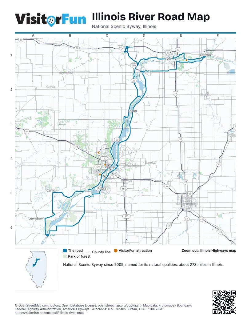
Highways it meets
Each highway it meets and the grid squares where they meet.
- US 136A6
- IL 97A6
- IL 78A6
- US 24B5
- IL 9B5
- IL 100B5
- IL 29C5
- IL 98C5
- I-474C5
- IL 116C4
- IL 8C4
- I-74C4
- US 150C4
- IL 26C4
- IL 17D3
- IL 18D2
- IL 71D1
- IL 89D1
- I-39E1
- US 51E1
- IL 251E1
- IL 351E1
- IL 178E1
- IL 23F1
- US 6E1
- I-180D1
- IL 6C4
- IL 40C4
- US 34D1
- IL 126D1
Towns along the Illinois River Road
In mile order, with the grid square of each.
- Havanamile 0, A6
- Kingston Minesmile 2, B5
- Glasfordmile 3, B5
- Bannermile 10, B5
- Cantonmile 16, B5
- St. Davidmile 21, B5
- Forest Citymile 54, B6
- Manitomile 58, B6
- Pekinmile 73, C5
- North Pekinmile 78, C5
- Bartonvillemile 78, C5
- Marquette Heightsmile 80, C5
- Creve Coeurmile 80, C5
- Peoriamile 82, C4
- East Peoriamile 82, C4
- Bay View Gardensmile 96, C4
- Spring Baymile 96, C4
- Laconmile 114, D3
- Henrymile 123, D2
- Hennepinmile 133, D2
- Markmile 138, D1
- Granvillemile 140, D1
- Standardmile 143, D1
- Cedar Pointmile 146, E1
- Oglesbymile 149, E1
- LaSallemile 153, E1
- North Uticamile 156, E1
- Ottawamile 164, F1
- Perumile 182, E1
- Spring Valleymile 186, E1
- Dalzellmile 186, E1
- De Puemile 193, D1
- Bureau Junctionmile 198, D1
- Sparlandmile 221, D3
- Hopewellmile 224, D3
- Chillicothemile 229, C3
- Romemile 232, C3
- Mossvillemile 239, C4
- Peoria Heightsmile 244, C4
- West Peoriamile 252, C4
- Mapletonmile 262, C5
- Princetonmile 270, D1
Things to do on the Illinois River Road map
© OpenStreetMap contributors, Open Database License, openstreetmap.org/copyright · Map data: Protomaps · Boundary: Federal Highway Administration, America's Byways · Junctions: U.S. Census Bureau, TIGER/Line 2026