

Kansas map
Manhattan Township map
About 54,699 people live here (Census Bureau, 2024 estimate). The sheet's index lists 138 streets; Tuttle Creek Boulevard, South Scenic Drive and South Manhattan Avenue cross the most grid squares. Things to do inside the boundary: Aggieville Brewing Company and Wildwood Adventure Park.
Open the map (PDF, US Letter)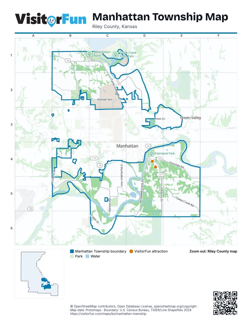
Street index of Manhattan Township
Each street on the sheet and the grid squares it crosses.
- Eagle RidgeB1, B2
- Freeman CircleB1
- Freeman RoadB1, C1
- Marjorie CourtB1
- McIntyre RoadB1
- North Seth Child RoadB1, B2
- Observation Point DriveB1, C1
- Tall GrassB1
- Tuttle Cove RoadB1, C1
- Tuttle Creek BoulevardB1, C1, C2
- Tuttle TerraceB1
- Backwater DriveC1
- Beaver Pond RoadC1
- Bent Tree DriveC1
- Highway 13C1
- Island CircleC1
- Island LoopC1
- Loop DriveC1
- Pfiel Creek RoadC1
- Riely Point RoadC1
- River LoopC1
- River Pond RoadC1
- Riverpond RoadC1, D1
- Rocky Ford AvenueC1, C2
- Rory CircleC1
- Rory RoadC1
- South Dam RoadC1
- Tall Timbers LoopC1
- Marlatt AvenueB2, C2
- Marque Hill RoadB2, C2
- Nix's PeakB2, C2
- Prairie Star DriveB2
- Sam's TrailB2
- Top of the World DriveB2
- Willowpond LaneB2
- Alecia DriveC2
- Barnes RoadC2, D2
- Chandler DriveC2
- Cindella DriveC2
- College AvenueC2, C3
- Colony LaneC2
- Denison AvenueC2
- Green Valley CircleC2
- Hill Valley DriveC2
- Hollow Tree LaneC2
- Kirkwood DriveC2
- Marion AvenueC2
- Mill RoadC2
- Potomac CrossingC2
- Purcell RoadC2
- Quail RoadC2
- River Bend RoadC2
- Rocky Ford CircleC2
- Rogers BoulevardC2
- Shady Valley DriveC2
- Valleydale DriveC2
- Valleywood DriveC2
- Walters DriveC2
- Casement RoadD2, D3
- Dyer RoadD2
- Julie LaneD2
- Nelson's LandingD2
- Wildcat Creek RoadB3
- Agronomy Field RoadC3
- Brookmont DriveD3
- Don Harbour DriveD3
- Knox LaneD3, E3
- Lilac LaneD3
- Mike PlaceD3
- Patricia PlaceD3
- Spruce PlaceD3
- South Scenic DriveA4, B4, B5
- Fort Riley BoulevardB4, B5
- Fossilridge DriveB4
- Hunter DriveB4
- Joseph DriveB4
- Shadowridge DriveB4
- Waterbridge RoadB4
- Wilson DriveB4
- Dunbar RoadC4
- Pottawatomie AvenueC4
- Rosencutter RoadC4, C5
- South Manhattan AvenueC4, C5, D5
- Adams StreetD4
- Chenango StreetD4
- Crestline DriveD4
- Diebler PlaceD4
- Elliott StreetD4
- Francis StreetD4
- Frontage RoadD4
- Gillett ViewD4
- Johnson RoadD4
- K LaneD4
- Lafayette DriveD4, E4
- McDowell Creek RoadD4, D5, D6
- Messenger RoadD4
- Noon StreetD4
- Oak Valley DriveD4, D5, E5
- Pillsbury DriveD4, D5, D6
- Pride DriveD4
- Rannells RoadD4
- Stadel RoadD4
- Sugar Bush LaneD4
- Temple LaneD4
- Tuttle Creek ViewD4
- Zeandale RoadD4, E4, E5
- East LaneE4
- Harwood RoadE4
- Moores LaneE4, E5
- Quarry RoadE4
- Allison AvenueB5
- Cox CircleB5
- Davis DriveB5
- OakwayB5
- Stagg Hill RoadB5, C5
- Summit CircleB5
- Summit DriveB5, C5
- Sunrise DriveB5, C5
- Vista RoadB5, C5
- Collins LaneC5, D5
- Henton RoadC5, C6
- Moehlman RoadC5
- Priboth RoadC5
- South 20th StreetC5, C6
- Blandin LaneD5
- Deep Creek RoadD5, E5, E6
- Garibay LaneD5
- Gehrt RoadD5
- Perry DriveD5
- South Collins LaneD5
- Crest Ridge CircleE5
- Dawn AvenueE5
- Eastern Hills DriveE5
- Ranch View CircleE5
- Sedam AvenueE5
- Sod LaneE5
- Kientz DriveC6
- McDowell Creek SpurD6
Things to do on the Manhattan Township map
Places on the map
- Aggieville Brewing
- Bison Loop
- Calvary Tabernacle
- Collins Lane Gardens
- Crestview Christian Church
- Dara's Fast Lane
- Fairmont Park
- Faith Baptist Church
- Faith Evangelical Free Church
- Irvine Ranch
- Kaw Valley Greenhouses
- Knox Lane Self Storage
- Konza Prairie Screnic Overlook
- Large Animal Research Center
- Large Dogs
- Northeast Community Park
- Observation Point
- Plant #2
- Prospect Hill
- Riley Point Campground
- Rocky Ford Campground
- Rocky Ford Turfgrass Research Center
- Small Dogs
- Stagg Hill
- Stagg Hill Golf Course
- Stretch Dog Park
- Sunrise Cemetery
- The Church of Jesus Christ of Latter-day Saints
- Tuttle Creek Lake Visitors Center
- Tuttle Creek Outlet Park
- Tuttle Creek State Park Archery Range
- Tuttle Forestry Research Center
- VMI Land Tract
- Washington Marlatt Memorial Park
- Washington Marlatt Park walking trail
- Wildcat Creek
- Wildcat Creek Golf & Fitness
- Willow Lake
- Willows Lake Student Farm
Next to Manhattan Township
- Green Valley
- Manhattan map
© OpenStreetMap contributors, Open Database License, openstreetmap.org/copyright · Map data: Protomaps · Boundary: U.S. Census Bureau, TIGER/Line Shapefiles 2024