

Kansas map
Manhattan map
About 54,699 people live here (Census Bureau, 2024 estimate). The sheet's index lists 300 streets; Kimball Avenue, Fort Riley Boulevard and Tuttle Creek Boulevard cross the most grid squares. Things to do inside the boundary: Aggieville, AJ's NY Pizzeria and Arrow Cafe & Bodega.
Open the map (PDF, US Letter)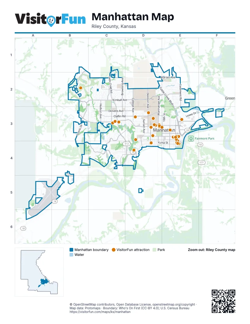
Street index of Manhattan
Each street on the sheet and the grid squares it crosses.
- Fort Riley BoulevardE3, C4, D4, E4
- Tuttle Creek BoulevardD2, E2, E3
- North Seth Child RoadC2, C3
- South Seth Child RoadC3, D3, D4
- East Poyntz AvenueE3
- Pillsbury DriveE3, E4
- Kimball AvenueB2, C2, D2, E2, B3
- Anderson AvenueB3, C3, D3
- Marlatt AvenueC2, D2, E2
- Pierre StreetD3, E3
- Bluemont AvenueD3, E3
- Leavenworth StreetD3, E3
- North Scenic DriveB3, B4
- McCall RoadE3
- North 4th StreetE3
- South 4th StreetE3, E4
- Discovery WayD2
- South Scenic DriveB4
- Claflin RoadC3, D3, E3
- Grand Mere ParkwayB1, B2
- Amherst AvenueC3, D3, C4
- Miller ParkwayB4, C4
- Denison AvenueD2, D3
- North Manhattan AvenueD2, D3
- Browning AvenueC2, C3
- Frontage RoadC3, E3
- Wildcat Creek RoadB3, A5, A6
- Dickens AvenueC3, D3
- Poyntz AvenueD3, E3
- Casement RoadE2, E3
- College AvenueD2, D3
- Wreath AvenueC2, C3
- Gary AvenueC2
- Candlewood DriveC2
- Hudson AvenueC2, C3
- Stagg Hill RoadC4, D4
- North 11th StreetE3
- North Juliette AvenueE3
- Allison AvenueC4, D4
- North Martin Luther King Jr DriveD3
- Griffith DriveE2
- North 3rd StreetE3
- South Juliette AvenueE3, E4
- Davis DriveC4
- South Martin Luther King Jr DriveD3, D4
- Rosencutter RoadD4
- South 10th StreetE3, E4
- South Manhattan AvenueD3, D4
- Hostetler DriveE3
- Westwood RoadD3, D4
- South 3rd StreetE3, E4
- Eureka DriveB5
- Sarber LaneE3
- Skyway DriveB5
- Richards DriveD4
- Redbud EstatesD3, D4
- Highland Ridge DriveB3
- Colorado StreetD4, E4
- Vanesta DriveC2
- Hayes DriveE2, E3
- North 10th StreetE3
- Little Kitten AvenueC2, C3
- Houston StreetD3, E3
- Humboldt StreetD3, E3
- Laramie StreetD3, E3
- Butterfield RoadE2
- Yuma StreetD4, E4
- Fair LaneD4, E4
- Vattier StreetD3, E3
- Sharingbrook DriveC3
- Levee DriveE3, F3
- Northfield RoadD2, E2
- Sunset AvenueD3
- North 9th StreetE3
- Merced DriveB2, C2
- Plymouth RoadC2, C3
- North 8th StreetE3
- Everett RoadC2
- Walters DriveD2, E2
- College Heights RoadD3
- Fremont StreetD3, E3
- El Paso LaneD4, E4
- Kearney StreetD3, E3
- Moro StreetD3, E3
- Corporate DriveA5
- Thurston StreetD3, E3
- Osage StreetD3, E3
- Potomac CrossingD1, D2
- South WreathC3, C4
- North 6th StreetE3
- Pottawatomie AvenueD4, E4
- Jardine DriveD3
- Tatarrax DriveC1, C2
- Bertrand StreetD3, E3
- North 5th StreetE3
- Bluehills RoadD2
- Brierwood DriveD4
- Mid-Campus DriveD3
- Hillview DriveD2
- Colbert Hills DriveB2, C2
- Anneberg CircleC3
- Heartland DriveB2
- Fairchild AvenueD3
- Vaughn DriveC2, D2, C3
- Arbor DriveC4
- Virginia DriveC2, C3
- North 12th StreetD3
- Dondee DriveC4
- Buttonwood DriveE2
- Wyndham HeightsB3, C3
- DeHoff DriveC4
- Hunting AvenueD3
- Allen RoadE2
- Brockman StreetD2, E2
- Mission AvenueD2, E2
- Snowbird DriveC2, D2
- Riley LaneE4
- Ratone StreetD3, E3
- Todd RoadD3
- Englewood StreetC2
- Brookville DriveE2
- South 5th StreetE3, E4
- Hobbs DriveC3, D3
- Cedar Crest DriveC2, C3
- Denholm DriveC2, C3
- Kerr DriveD2, D3
- Paul Revere RunD1, D2
- Meadowlark RoadD2
- Cassell RoadC2, D2, C3
- Westport DriveC3, D3
- Seaton AvenueC2
- Firethorn DriveC3, C4
- Garden WayC3
- Eureka TerraceB5
- South 9th StreetE3, E4
- North Dartmouth DriveC3
- South 15th StreetD3, D4
- Johnstowne CircleD2
- Nevada StreetC2, C3
- Newfoundland DriveB3
- South 8th StreetE3, E4
- North 14th StreetD3
- South 6th StreetE3, E4
- Givens RoadC3
- North 16th StreetD3
- Sumac DriveC4, D4
- Ivy DriveE2
- Ella LaneC2
- Stone DriveB3
- Robinson DriveC3
- Tuttle StreetE2
- Pecanwood DriveC2
- Agronomy Central RoadD2
- Laussac DriveC4
- Agronomy Field RoadD2
- Sunny Slope LaneE3
- Poliska LaneD4
- Strong AvenueE2, E3
- Patricia PlaceE2
- Green AvenueE2
- Hillcrest DriveD3
- Westbank WayC2, C3
- Ranser RoadD2, D3
- South 11th StreetE3, E4
- Brooklawn DriveE2
- Kirkwood DriveD2, E2
- Westloop PlaceC3
- Brookmont DriveE2
- Dix DriveE2
- Newbury StreetC2
- Beechwood TerraceC3
- Pebblebrook CircleB3, C3
- Spain DriveE2
- Avery AvenueC2, C3
- Knoxberry DriveE2
- Heartland Valley RoadB2
- Judson StreetE2, E3
- South Delaware AvenueD3, D4
- McCain LaneD3
- Stone Crest DriveB3
- Scenic CrossingB3, C3
- Positano DriveF3
- Flint Hills PlaceD2
- Kenmar DriveC2, D2, D3
- Central Park RoadD3
- South 12th StreetD3, D4
- Summit AvenueD3, D4
- South Port DriveF3
- James AvenueC2
- Platt StreetD3
- Treesmill DriveC2
- Sloan StreetE2
- Griffith TerraceE2
- Grandview DriveD3
- Kretschmer DriveE3
- Ehlers RoadE3
- Hackberry AvenueE2
- Ridge DriveD3, D4
- Conrow DriveC3
- Londondery DriveC2
- Buckingham StreetC2
- North Delaware AvenueD3
- South Airport RoadB5
- Victory DriveB1, B2
- Starlight LaneC3
- South Dartmouth DriveC3
- Barrington DriveB3, C3
- Chase PlaceD3
- Shadowridge DriveB4, C4
- Shuss RoadC4, D4
- Lundin DriveC2, C3
- Nichols StreetC3
- South 16th StreetD3, D4
- Commons PlaceC4, D4
- Knox LaneE2
- Hawthorne Woods TerraceC2
- Highland Grove DriveB3
- Purple Aster PlaceB2
- Beck StreetE2, E3
- Prairie Glen PlaceE2
- Nelson's LandingE2
- Village DriveC3
- Goodrich DriveD2, E2
- Grandview TerraceD3
- Kings RoadC2, C3
- Sunnyside DriveC2
- Bethany DriveC3
- South 14th StreetD3, D4
- Wilson DriveC4
- Bluestem TerraceD2, E2
- North 15th StreetD3
- Gillespie DriveC4
- Wayne DriveC2
- Westchester DriveC2
- Stonehenge DriveC2
- Effingham StreetC2
- Plumthicket DriveB4, C4
- Overlook DriveC3
- Candlecrest CircleC2
- Highland Pointe DriveB3
- Oakbrook PlaceC4
- Players TerraceB2
- Lawrence RoadC2
- Carlson PlaceE3
- Leone Ridge DriveC4
- Windsong LaneC3
- Augusta WayE2
- Spook Rock RoadE1, E2
- Powerline PlaceE2
- Serum Plant RoadD2, D3
- Vanesta PlaceB2, C2
- Harvey DriveE2
- Southwind RoadC4, D4
- Tamarron TerraceC2, D2
- Bramblewood DriveB4, C4
- Buckner DriveC2
- Agriculture RoadD2
- Lincoln DriveE2
- Waterford PlaceC3, D3
- Wildcat RidgeD3
- Heritage Square DriveF3
- Tamarak DriveC4
- Southwind PlaceC4, D4
- MacBrayne DriveB1
- MacLeod DriveB1, B2, C2
- Tecumseh RoadD3
- Westview DriveD3
- Anneberg DriveC3
- Musil DriveC3
- North 3rd PlaceE3
- College View RoadD3
- Oxford PlaceC3
- Kauffman DriveC2
- Oakdale DriveD3
- Valley DriveD3, D4
- Drake DriveC3, C4
- Edgerton AvenueD3
- Fordham RoadC3, C4
- Kingwood DriveD4
- Churchill StreetC2
- Jarvis DriveD3
- Oregon LaneC2
- Connecticut AvenueD3
- Harry RoadD3
- Lilac LaneE2
- Tobacco RoadB2
- Chimney Rock RoadC3
- Church AvenueD2, E2
- Warner Park RoadC4
- Frontier LaneC3
- Rockhill RoadD4
- Meadowbrook LaneC3
- Wickham RoadD3
- Park Grove DriveC4
- Stillman DriveD2, E2
- Brianna CourtC4
- Fairview AvenueD3
- Ledgestone Ridge CourtB3, B4
- Walnut DriveD4
- Woods DriveC2
Things to do on the Manhattan map
- Aggieville
- AJ's NY Pizzeria
- Arrow Cafe & Bodega
- Bourbon & Baker
- Colbert Hills Golf Course
- El Patrón Mexican Restaurant & Cantina
- Flint Hills Discovery Center
- Guilty Biscuit
- Houlihan's
- K-State Gardens
- Kansas State University
- Manhatchet
- Manhattan Arts Center
- Manhattan Brewing Company
- Manhattan Running Company
- Manhattan Town Center
- Marianna Kistler Beach Museum of Art
- McCain Performance Series
- Midwest Dream Car Collection
- Museum of Art + Light
- Nico's Little Italy
- Radina's Bakehouse
- Riley County Historical Museum
- SNW Gallery & Custom Frames
- Sunset Zoo
- Tallgrass Tap House
- The Boutique MHK
- The Chef Cafe
- Wolf House Museum
Places on the map
- Aggieville
- Amanda Arnold Elementary
- Bill Snyder Family Stadium
- Blue Hills Shopping Center
- Bluemont Hill Park
- Briarcliffe Park
- Candlewood Shopping Center
- CiCo Park
- City Park
- Colbert Hills Golf Course
- East Campus
- East Ramp
- Eisenhower Baseball Complex
- Eisenhower Middle School
- FedEx Ship Center
- Frank Anneberg Park
- Girl Scout Park
- Grand Mere Village
- Jerry Dishman Lake
- K-State Research Park
- Kansas National Guard
- Kansas State Post Office
- Kansas State University
- Ledgestone Park
- Longview Hill
- Manhattan Country Club
- Manhattan Crossing
- Michael-Ross Audubon Preserve
- Northview
- Plaza de Maria
- Plaza West
- Riley County Transfer Station
- Roger Schultz Community Park
- Seth Child Commons
- Southeast Park
- Sunset Cemetery
- Warner Memorial Park
- Westloop Shopping Center
- Wildcat Creek Linear Park
© OpenStreetMap contributors, Open Database License, openstreetmap.org/copyright · Map data: Protomaps · Boundary: Who's On First (CC-BY 4.0); U.S. Census Bureau