

Kansas map
North Central Kansas map
The sheet's index lists 13 highways; I-70, US 40 and US 36 cross the most grid squares. Things to do inside the boundary: Aggieville, Aggieville Brewing Company and AJ's NY Pizzeria. Also on it: Abilene, Alma and Belleville.
Open the map (PDF, US Letter)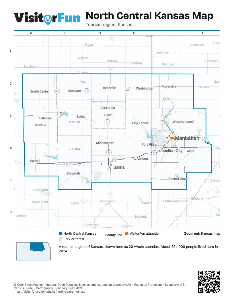
Highway index of North Central Kansas
Each highway on the sheet and the grid squares it crosses.
- I-70A4, B4, B5, C4, D4, E4, F4
- I-135C4, C5
- I-335F5
- US 24E3, E4, F4
- US 36A2, B2, C2, D2, E2, F2
- US 40A4, B4, B5, C4, D4, E4, F4
- US 77E2, E3
- US 81C2, C3, C4, C5
- US 281A2, B2
- KS 4C5
- KS 14B2, B5
- KS 18E4
- KS 177E4
Things to do on the North Central Kansas map
- Aggieville
- Aggieville Brewing Company
- AJ's NY Pizzeria
- Arrow Cafe & Bodega
- Bluemont Hotel
- Bourbon & Baker
- Colbert Hills Golf Course
- Columbian Theatre
- Comfort Suites Manhattan
- Courtyard Manhattan Aggieville
- Dwight D. Eisenhower Presidential Library, Museum and Boyhood Home
- El Patrón Mexican Restaurant & Cantina
- Flint Hills Discovery Center
- Four Points by Sheraton Manhattan
- Guilty Biscuit
- Holiday Inn Express & Suites Manhattan
- Holiday Inn Manhattan at the Campus
- Houlihan's
- K-State Gardens
- Kanopolis State Park
- Kansas I-70
- Kansas State University
- Kaw Mission State Historic Site
- Liquid Art Winery
- Manhatchet
- Manhattan Arts Center
- Manhattan Brewing Company
- Manhattan Conference Center
- Manhattan Running Company
- Manhattan Town Center
- Marianna Kistler Beach Museum of Art
- McCain Performance Series
- Midwest Dream Car Collection
- Museum of Art + Light
- Mushroom Rock State Park
- Nico's Little Italy
- OZ Museum
- Parkwood Inn & Suites
- Pawnee Indian Museum State Historic Site
- Prairiewood
- Radina's Bakehouse
- Riley County Historical Museum
- Rolling Hills Zoo
- SNW Gallery & Custom Frames
- Sunset Zoo
- Tallgrass Tap House
- The Boutique MHK
- The Chef Cafe
- The Garage
- Tuttle Creek State Park
- Wildwood Adventure Park
- Wolf House Museum
- World's Largest Ball of Twine
Places on the map
- Abilene
- Alma
- Belleville
- Beloit
- Clay Center
- Concordia
- Council Grove
- Ellsworth
- Fort Riley
- Junction City
- Manhattan
- Mankato
- Marysville
- Minneapolis
- Osborne
- Russell
- Salina
- Smith Center
- Washington
- Westmoreland
Next to North Central Kansas
- Northeast Kansas map
- Northwest Kansas map
- South Central Kansas map
- Southeast Kansas map
- Southwest Kansas map
- South Central Nebraska
- Southeast Nebraska
© OpenStreetMap contributors, Open Database License, openstreetmap.org/copyright · Map data: Protomaps · Boundary: U.S. Census Bureau, Cartographic Boundary Files 2024