

Minnesota map
Itasca County map
About 45,442 people live here (Census Bureau, 2024 estimate). The sheet's index lists 300 streets; State Highway 38, County Road 31 and State Highway 6 cross the most grid squares. Things to do inside the boundary: Judy Garland Museum.
Open the map (PDF, US Letter)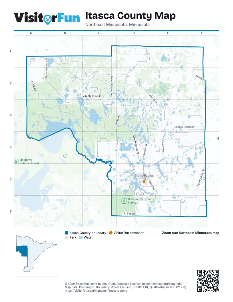
Street index of Itasca County
Each street on the sheet and the grid squares it crosses.
- Voyageur HighwayA1, D5, D6
- US Highway 2C4
- Northwest 4th StreetD5
- South Pokegama AvenueD5
- Highway 169 WestF4
- Bridge StreetE6
- North Pokegama AvenueD5
- Northeast 4th StreetD5
- Corey StreetE4, E5
- Main Avenue EastC4
- Main AvenueC4
- 4th Street EastD5
- United States Route 2F6
- State Highway 38D1, D2, D3, D4, D5
- State Highway 6C1, C2, C3, C4
- State Highway 46A1, A2, B2, B3
- County Road 16F5
- State Highway 286C3, D3
- County Road 20F5
- 1st StreetD2, C3, F4, E5
- 2nd StreetD2, F4, E5
- McKinney Lake RoadD5
- County Road 605E1
- 2nd AvenueD2, E4, E5, E6
- Division StreetC4
- Northwest 3rd AvenueD5
- Main StreetD2
- State 6 NortheastC5
- Cedar St / State Highway 38D2
- State Highway 65E6
- Scenic HighwayD2, E2, E3, E4
- Forest Rd 2171A3, B3, A4
- County Road 32A2, B2, A3, B3
- County Road 29A2, B2, C2
- County Road 4B2, C2, B3, C3
- County Road 31B1, C1, A2, B2, C2
- River RoadD2, D5, E5, E6
- County Highway 52E2, F2, E3
- County Road 14C2, D2
- County Road 35B3, C3
- County Road 45D3, E3
- County Road 10E5
- County Road 72E6
- Spider Lake RoadD3, D4
- County Road 48C3, D3, C4, D4
- County Road 40D1
- County Road 8E3, E4, F4
- County Road 19C4, D4
- County Road 37C3, B4, C4
- County Road 26B1, B2
- North Buck Lake RoadF3
- Wabana RoadD4
- Wolf Lake TrailE3, F3
- County Road 58E4, F4
- County Road 12E4, E5, F5
- County Road 67E5, D6, E6
- Clearwater RoadD4, E4
- East Shore DriveF4, F5
- County Road 13A2
- Splithand RoadD6, E6
- County Road 50D3, E3, E4
- County Road 44C4
- County Road 51E3
- Trout Lake RoadD5, E5
- County Road 340D2, E2
- County Road 70E5
- County Road 57E4
- Sugar Lake TrailD5, D6
- County Road 54F3
- County Road 56E4, F4
- Pincherry RoadD4, D5
- East Bass Lake RoadD4, D5
- Sugar Hills RoadD5, D6
- Turtle Lake RoadC2, D2
- County Road 623D1
- County Road 622C2, C3
- County Road 42D1, D2
- County Road 69E4, E5
- Danson RoadE5, E6
- County Road 25F6
- County Road 17D5
- County Road 621A1
- Happy Hollow RoadE5, E6
- County Road 74E6, F6
- Prairie Lake RoadD4, D5
- County Road 34B3
- County Road 71E5
- County Road 60F1, E4
- County Road 18C4, C5
- Laplant RoadD5, D6
- County Road 5D1
- County Road 24B1
- County Road 22F2
- Smith Lake RoadD3, D6
- East Deer Lake RoadD4
- Harristown RoadD5, E5
- County Road 62D4, D5
- West Splithand RoadD6
- Horseshoe Lake RoadD2, D3, D5
- Golf Course RoadD5
- South Crystal Springs RoadD5, D6
- County Road 53E3
- County Highway 29C2
- County Highway 61D5, E5
- County Road 47D3
- Northwest 3rd StreetD5
- Airport RoadD5
- County Road 59E4
- County Road 89C4
- Isleview RoadD5
- Southeast 2nd AvenueD5
- Scenic DriveD4, E4
- West Shore DriveF4, F5
- Wendigo RoadE5
- Lake StreetC4, F4, D5, E6
- County Road 83E4, F4
- Crystal Springs LoopD5
- Southeast 7th AvenueD5
- Northwest 5th StreetD5
- County Road 88D4, D5
- County Road 79D1
- 9th AvenueE4, E5, E6
- County Road 73E6
- La Prairie AvenueD5
- Crystal Springs RoadD5
- Mishawaka Shores DriveD5
- County Road 273D5
- Greenrock RoadF2
- County Highway 48D3
- Central AvenueF4, D5
- Southeast 7th StreetD5
- Alice AvenueE4
- Cemetary RoadC2, D2
- Southwest 4th StreetD5
- Roosevelt StreetE5
- Northeast 5th StreetD5
- 1st Street NortheastD1, C4
- Mishawaka RoadD5
- County Highway 49D3
- Northwest 8th StreetD5
- North Sugar Lake TrailD5
- Green Rock RoadF2
- 8th Street SoutheastD5
- Southeast 17th StreetD5
- County Highway 86F4
- County Road 55F3
- Southwest 5th AvenueD5
- Gary StreetE4
- Division AvenueD2, E5
- County Road 28C5
- Northeast 8th StreetD5
- Southeast 10th StreetD5
- Morgan StreetE4
- Oakdale DriveD5
- Crystal Lake BoulevardD5
- Cole StreetE5
- Southeast 13th StreetD5
- Southeast 11th StreetD5
- Southeast 21st StreetD5
- County Highway 4C3
- County Highway 28A1
- Glenwood DriveD5
- Coleman Lake Road NortheastA2
- 11th Avenue SouthwestD5
- Northwest 10th AvenueD5
- West 3rd AvenueF4
- County Highway 15E4
- Northeast 6th AvenueD5
- Alvwood Road NortheastA2
- Huskie BoulevardD2
- 1st Avenue NortheastD1, C4, D5
- County Road 87D5
- Ethel StreetE4
- Gunn StreetE5
- Lakeview StreetF4
- 2nd Street NortheastC4, D5
- Northwest 11th StreetD5
- 7th StreetF4
- Old Hwy 169F4
- County Highway 24A1
- County Highway 78D2
- Hodgins AvenueE4
- Pine Tree DriveD2, C3
- County Road 68E6
- Highway 22F2
- Southwest 21st StreetD5
- Southeast 1st StreetD5
- Morrison AvenueE5
- County Highway 87D5
- Arctic RoadC4
- Lake View StreetF4
- Ida StreetD2
- Highway 133F6
- County Highway 31A2
- 124th Street NortheastC5
- 72nd Avenue NortheastC4
- County Road 336E3, E4
- Forest Rd 2229A2, B2
- County Road 539E3, F3
- County Road 560F5
- County Road 434E5
- Shinglemill RoadC6, D6
- Snake TrailF2
- Decker Lake RoadA2, A3
- County Road 158B3
- Link Lake TrailF2
- Orange Lake RoadD4
- 8 Mile RoadA2, D6
- County Road 525D1, E1
- Forest Rd 2402C2
- South Feeley RoadE5, F5, E6, F6
- Arbo RoadD4, E4, E5
- County Road 236D1, D2
- County Road 126B2
- County Road 127B2, C2
- County Road 128C4, D4
- Wilderness TrailD3, E3
- St Louis Itasca Judicial RoadF1, F2
- County Road 134C3
- County Road 133C3
- County Road 163B2
- Blandin RoadD6
- Sunny Beach RoadD5, E5
- County Road 347D2, D3
- County Road 149B2
- Alder RoadC3, D3
- County Road 430E6
- Smith Creek TrailD6
- Horseshoe Forest TrailE1
- County Road 551E1, E2, F2
- Spang RoadD6
- Holstrum Spur TrailE1
- County Road 333E3
- County Road 257D5
- Bluewater RoadD4
- Little Sugar Lake RoadD5, D6
- Forest Rd 2196B3
- Jack the Horse Lake RoadD2, D3
- County Road 131A2
- Forest Rd 2423C2, D2
- County Road 342E2
- County Road 145B2
- County Road 243D3
- County Road 129C4
- North Sugar Lake RoadD5
- Forestry Rd 2182D2
- Chase Lake RoadC4, D4
- North Bass Lake RoadD4
- County Road 325D4, E4
- Moose Point RoadD5
- County Road 425F6
- County Road 341E2, E3
- Crickett HillD6
- Lum Lake RoadD3, E3
- County Road 343E3, E4
- County Road 428F6
- Barb Clark Forestry RoadB1, B2
- County Road 583F3
- Forest Rd 2384A3, B3
- County Road 143C4
- Forest Rt 2201A2
- Forest Rd 2168A4
- County Road 429F6
- County Road 142C4
- North Nature Lake RoadB2
- Farm Camp RoadD2
- County Road 234C5, D5
- Hall RoadF5, D6
- Eagles Nest RoadB3
- Valley River Forest RoadE1
- Feeley RoadE5, F5, E6
- Forest Rd 2187C2
- County Road 523E1
- County Road 229D1
- Wasson Lake Forest RoadE2
- Bearville 528F1, F2
- ThistlepatchD6
- County Road 542E1
- Forest Rd 3153B3
- Camp Five RoadC2
- County Road 242C5, D5
- County Road 344D2
- South Shoal Lake RoadD5
- Bluebird DriveE5
- County Road 153C3, C4
- County Road 345E3
- Wildview RoadD3
- Jess Harry RoadE5
- County Road 252C2, C3
- West Deer Lake RoadD4
- West Sturgeon Forest RoadF2
- County Road 150C1, C2
- County Road 162C5
- Rearing Pond RoadA1, B1, F2
- Mac RoadC3, D3
- Remer GradeC6, D6
- Freestone RoadD4
- Lost Lake TrailE2
- County Road 348D2
- County Road 238D4
Things to do on the Itasca County map
Places on the map
- Alice Lake
- Allen Lake
- Alvwood Township
- Amen Lake
- American Legion Memorial Park
- Amik Lake
- Anderson Lake
- Ann Lake
- Antler Lake
- Arbo Township
- Ardenhurst Township
- Arrowhead Lake
- Aspen Lake
- Ball Club Lake
- Balsam Lake
- Balsam Township
- Bartlet Lake
- Barwise Lake
- Bass Lake
- Bass Lake Precinct
- Batson Lake
- Battle Lake
- Bear Lake
- Bearville Township
- Beatrice Lake
- Beauty Lake
- Beaver Lake
- Beaver Lodge Reservoir
- Bello Lake
- Bengal Lake
- Big Fork State Forest
- Black Duck State Forest
- Blackduck State Forest
- Blandin Industrial Forest
- Bowstring State Forest
- George Washington State Forest
- Golden Anniversary State Forest
- Golden Annviversary State Forest
- Morph Meadows Wildlife Management Area
- Scenic State Park
© OpenStreetMap contributors, Open Database License, openstreetmap.org/copyright · Map data: Protomaps · Boundary: Who's On First (CC-BY 4.0); Quattroshapes (CC BY 2.0)