

Missouri road map
I-64 in Missouri map
I-64 is about 39 miles in Missouri. It has 50 exits, from Exit 1A at mile 0 to Exit 40B at mile 39. It meets 12 highways; US 40, US 61 and MO 364 meet it in the most grid squares.
Open the map (PDF, US Letter)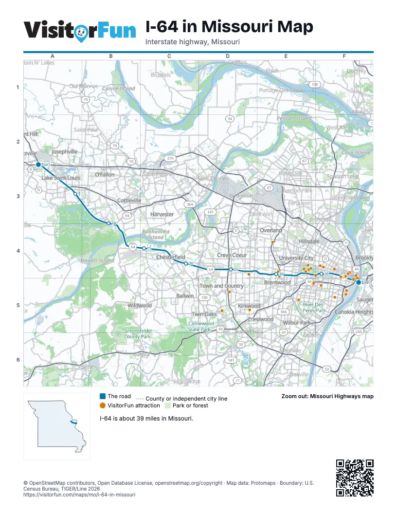
Exits on I-64 in Missouri
Each exit in mile order, with its grid square.
- Exit 1Amile 0, A2
- Exit 210Bmile 0, A2
- Exit 1Bmile 0, A2
- Exit 1Cmile 1, A3
- Exit 2mile 3, A3
- Exit 4Amile 4, A3
- Exit 4Bmile 4, A3
- Exit 6mile 6, A3
- Exit 9mile 9, B3
- Exit 10mile 11, B4
- Exit 11mile 11, B4
- Exit 14mile 14, B4
- Exit 16mile 16, C4
- Exit 17mile 17, C4
- Exit 19Amile 18, C4
- Exit 19Bmile 19, C4
- Exit 20mile 20, C4
- Exit 21mile 20, C4
- Exit 22mile 21, C4
- Exit 23mile 23, D4
- Exit 24mile 24, D4
- Exit 25mile 25, D4
- Exit 26mile 26, D4
- Exit 27mile 27, D4
- Exit 28Amile 27, D4
- Exit 28Bmile 28, E4
- Exit 30mile 30, E4
- Exit 31B-Amile 30, E4
- Exit 1A/1Bmile 31, E4
- Exit 31Amile 31, E4
- Exit 31Bmile 31, E4
- Exit 33Amile 32, E4
- Exit 33Bmile 32, E4
- Exit 33Cmile 32, E4
- Exit 34Amile 33, E4
- Exit 34Bmile 34, E4
- Exit 36Amile 35, F4
- Exit 36Cmile 36, F4
- Exit 36Bmile 36, F4
- Exit 37Amile 37, F4
- Exit 37Bmile 37, F4
- Exit 38Amile 37, F4
- Exit 38Bmile 38, F5
- Exit 39Amile 38, F5
- Exit 39Bmile 39, F5
- Exit 40mile 39, F5
- Exit 40Amile 39, F5
- Exit 291Amile 39, F5
- Exit 291Bmile 39, F5
- Exit 40Bmile 39, F5
Highways I-64 meets
Each highway it meets and the grid squares where they meet.
- US 40A2, A3, B4
- US 61A2, A3, B4
- MO 364A3
- MO 94B4
- MO 340C4
- MO 141D4
- I-270D4
- US 67D4
- I-170E4
- I-70F5
- I-55F5
- I-44F5
Towns along I-64 in Missouri
In mile order, with the grid square of each.
- Wentzvillemile 0, A2
- Lake St. Louismile 1, A3
- O'Fallonmile 4, A3
- Dardenne Prairiemile 4, A3
- Weldon Springmile 10, B4
- Chesterfieldmile 13, B4
- Town and Countrymile 21, C4
- Creve Coeurmile 23, D4
- Country Life Acresmile 25, D4
- Frontenacmile 26, D4
- Crystal Lake Parkmile 26, D4
- Huntleighmile 27, D4
- Laduemile 27, D4
- Richmond Heightsmile 30, E4
- Rock Hillmile 30, E4
- Brentwoodmile 30, E4
- Claytonmile 30, E4
- Maplewoodmile 31, E4
- St. Louismile 32, E4
Things to do on the I-64 in Missouri map
- Plaza Frontenac
- Saint Louis Galleria
- Saint Louis Art Museum
- Saint Louis Zoo
- Missouri History Museum
- Forest Park
- The Muny
- The Hill
- Saint Louis Science Center
- World Chess Hall of Fame
- Cathedral Basilica of Saint Louis
- The Fabulous Fox Theatre
- St. Louis Aquarium at Union Station
- St. Louis Central Library
- City Museum
- Busch Stadium
- Busch Stadium Tours & Cardinals Hall of Fame Museum
- Federal Reserve Bank of St. Louis
- Gateway Arch National Park
- Riverboats at the Gateway Arch
© OpenStreetMap contributors, Open Database License, openstreetmap.org/copyright · Map data: Protomaps · Boundary: U.S. Census Bureau, TIGER/Line 2026