

New Jersey map
West New York map
About 52,975 people live here (Census Bureau, 2024 estimate). The sheet's index lists 74 streets; Bergenline Avenue, Park Avenue and Boulevard East cross the most grid squares. Also on it: 7-Eleven, Acme and Albio Sires Elementary School.
Open the map (PDF, US Letter)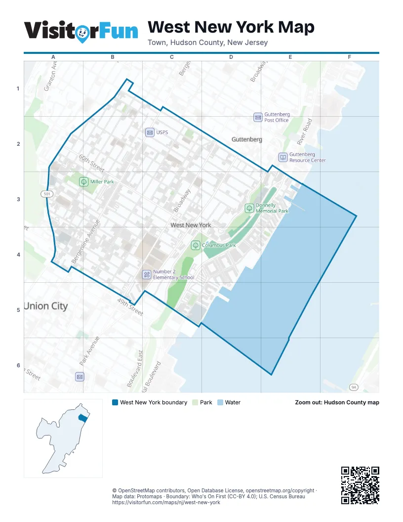
Street index of West New York
Each street on the sheet and the grid squares it crosses.
- 64th StreetB1, B2, C2, D2, D3
- 65th StreetB1, B2, C2, D2, D3
- 66th StreetB1, C2, D2, D3
- 67th StreetB1, C1, C2, D2, E3
- Adams StreetB1, A2, B2, A3
- Bergenwood AvenueB1
- Jackson StreetB1, B2, A3, B3
- Jefferson StreetB1, A2, B2, A3
- John F. Kennedy BoulevardB1, A2, B2, A3, A4
- Polk StreetB1, C1, B2, A3, A4
- Bergenline AvenueC1, B2, C2, B3, A4, B4
- 58th StreetA2, B3, C3, C4
- 59th StreetA2, B3, C3, C4
- 60th StreetA2, B2, B3, C3, C4
- 61st StreetA2, B2, C2, C3, D3
- Washington StreetA2, B2, A3
- 62nd StreetB2, C2, C3, D3
- Harrison PlaceB2, C2, B3
- Madison StreetB2, C2, A3, B3, A4
- Van Buren PlaceB2, B3
- 63rd StreetC2, C3, D3
- Dewey AvenueC2, D2
- Hudson AvenueC2, C3, B4, C4, B5
- Monroe PlaceC2, C3
- Palisade AvenueC2, B3, C3, B4
- Tyler PlaceC2, B3, C3
- BroadwayD2, C3, B4, C4, B5
- Lincoln PlaceD2, D3
- McKinley PlaceD2, D3
- Park AvenueD2, C3, D3, C4, B5, C5
- Boulevard EastE2, D3, E3, C4, D4, C5
- 52nd StreetA3, A4, B4, B5, C5
- 53rd StreetA3, A4, B4
- 54th StreetA3, A4, B4, C4
- 55th StreetA3, B3, B4, C4
- 56th StreetA3, B3, B4, C4
- 57th StreetA3, B3, C4
- Schley PlaceA3, B3
- Gaw PlaceB3, B4
- Grant PlaceB3, B4
- Buchanan PlaceC3, C4
- Fillmore PlaceC3
- Johnson PlaceC3, D3
- Westover PlaceC3, D3
- Highland PlaceD3
- Hillside RoadD3, E3, C4, D4
- Kingston CourtD3, E3
- Monitor PlaceD3
- Oswego CourtD3, E3, E4
- Port Imperial BoulevardD3, E3, C4, D4, C5
- Albany CourtE3
- Avenue at Port ImperialE3, D4, E4, C5, D5
- Brower CourtE3
- Buffalo CourtE3
- Farragut PlaceE3
- Fulton CourtE3
- Half Moon CourtE3
- Harbor PlaceE3
- Lydia DriveE3
- Midland CourtE3
- Newburgh CourtE3, D4, E4
- Price CrescentE3
- River RoadE3
- Roslyn CourtE3
- Slaugh CourtE3
- 49th StreetA4
- 50th StreetA4, B4, B5
- 51st StreetA4, B4, B5, C5
- Murphy PlaceA4
- Fairview TerraceC4, C5
- Kinston CourtD4
- North Park CourtD4
- Riverwalk PlaceD4, D5
- Riverbend DriveC5
Places on the map
- 7-Eleven
- Acme
- Albio Sires Elementary School
- Bank of America
- Columbus Park
- CVS Pharmacy
- Donnelly Memorial Park
- Food Bazaar
- GameStop
- Gethsemane Baptist Church
- Harry Bain Elementary School
- Harry L Bain Elementary School
- Iglesia Adventista Del Septimo
- Jain Samaj of USA
- Kingdom Hall
- La Fiesta Supermarket
- Love of Jesus Family Church
- McDonald's
- Memorial High School
- Memorial Park
- Mi Rinconsito Colombiano
- Miller Park
- Miller Stadium
- Nazareth Baptist Church
- Number 1 Elementary School
- Number 2 Elementary School
- Number 4 Elementary School
- Number 5 Elementary School
- Our Lady of Libera Church
- Our Lady of Liberia School
- P.F. Chang's
- Popeyes
- Popular
- Provident Bank
- QuickChek
- Saint John's Lutheran Church
- USPS
- Veterans Memorial Park
- West New York Middle School
Next to West New York
- Guttenberg
- Union City map
© OpenStreetMap contributors, Open Database License, openstreetmap.org/copyright · Map data: Protomaps · Boundary: Who's On First (CC-BY 4.0); U.S. Census Bureau