

Ohio map
Plain Township map
About 53,408 people live here (Census Bureau, 2024 estimate). The sheet's index lists 300 streets; Market Avenue North, Middlebranch Avenue Northeast and School Bus Loop cross the most grid squares. Things to do inside the boundary: Comfort Inn Hall of Fame and Hampton Inn & Suites Canton.
Open the map (PDF, US Letter)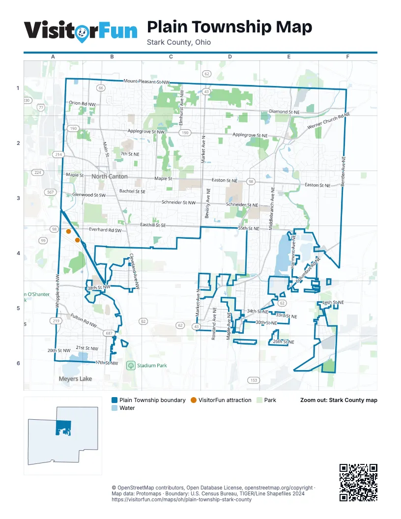
Street index of Plain Township
Each street on the sheet and the grid squares it crosses.
- Atlantic Boulevard NortheastD5, E5
- Malone Parkway NortheastC5, D5
- Malone Parkway NorthwestC5
- Market Avenue NorthD1, D2, D3, C4, D4, C5
- Columbus Road NortheastE4, F4, D5, E5
- South Main StreetB3, B4
- North Main StreetB1, B2, B3
- Cleveland Avenue NorthwestB1, B4, B5
- Kent Avenue NortheastD1
- Easton Street NortheastD3, E3, F3
- Applegrove Street NorthwestA2, B2, C2, D2
- Whipple Avenue NorthwestA3, A4, A5, A6
- Applegrove Street NortheastB2, D2, E2
- East Maple StreetB3, C3, D3
- Fulton Road NorthwestA5, B5, B6
- 30th Street NortheastC5, D5, E5, F5
- Portage Street NorthwestA2, B2, B3
- Everhard Road SouthwestB4
- Everhard Road NorthwestA4, B4
- Mahoning Road NortheastF5, E6, F6
- Charlotte Street NorthwestB2
- Louisville Street NortheastE6, F6
- Park DriveB6
- Dressler Road NorthwestA3
- Middlebranch Avenue NortheastE1, E2, E3, D4, E4, D5
- Diamond Street NortheastD1, E1, F1
- Bentler Avenue NortheastF1, F2, F3, F4
- Firestone Road NortheastD2, E2, D3, D4
- Werner Church Road NortheastF1, E2, F2
- Schneider Street NortheastD3, E3
- Mount Pleasant Street NorthwestA1, B1, C1
- 34th Street NortheastC5, D5, E5, F5
- 55th Street NortheastD4, E4
- Harmont Avenue NortheastE4, E5
- Martindale Road NortheastD5
- 38th Street NorthwestA5, B5
- Glenwood Street SouthwestA3, B3
- Easthill Street SoutheastB3, C3, C4
- Elmhurst Avenue NorthwestC1, C2
- Pittsburg Avenue NorthwestA1, A2
- Wise Avenue NorthwestA2, A3, A5
- West Maple StreetA3, B3
- Schneider Street NorthwestC3, D3
- Maple Avenue NortheastD5
- Spangler Street NortheastC5, D5
- Schneider Street SoutheastB3, C3
- Mount Pleasant Street NortheastD1, E1
- Orion Road NorthwestA1, B1
- Lindy Lane Avenue SouthwestA3, B3
- Broad Avenue NorthwestB5, B6
- Harrison Avenue NorthwestB4, B5
- Harrisburg Avenue NortheastD5, D6
- Hillcrest Avenue NorthwestB2, B3
- Regent Avenue NortheastE5
- Burkey Road NorthwestB1
- 44th Street NorthwestB4
- 39th Street NortheastC5, D5
- 55th Street NorthwestC4, D4
- Marquardt Avenue NorthwestC2
- Ivy Street NorthwestC1, D1
- Marquardt Avenue NortheastC2, C3
- 44th Street NortheastC4, D4
- Lesh Street NortheastF5
- Hills and Dales Road NorthwestA5
- Plain Center Avenue NortheastD4, D5
- Ream Street NorthwestB2, B3
- Batton Street NorthwestA2
- West Maple Street NorthwestA3
- Beverly Avenue NortheastD1, D2, D3, D5
- School Bus LoopB2, B3, D3, E3, B5, B6
- Croydon Drive NorthwestA5, B5
- Marelis Avenue NortheastD1, D2, D3
- Mc Dowell Street NortheastD3, E3, F3
- 21st Street NorthwestA6, B6
- 31st Street NortheastD5, E5
- Boettler Street NortheastE2, F2
- 7th Street NortheastB2, C2
- Roosevelt Avenue NortheastD4, D5, D6
- Forestview Street NortheastE2, E3
- Lindford Avenue NortheastD3, D4
- Rolling Ridge Road NortheastF2, E3, F3
- 20th Street NorthwestA6, B6
- Chaucer Drive NortheastE3, E4
- 22nd Street NorthwestA6, B6
- Grove Street NortheastD3, E3, F3
- Kirby Avenue NortheastE2, E3, E4, E5
- Darlington Road NorthwestA4, A5, B5
- Woodcrest Avenue NortheastD1, D2, D3
- 33rd Street NortheastC5, D5, E5
- Demington Avenue NorthwestB5, B6
- Orchard Dale Drive NorthwestB4
- Clearview Avenue NorthwestB5, B6
- Guilford Avenue NorthwestB4, B5
- 26th Street NortheastD6, E6
- Stone Crossing Street NortheastD2, D3
- Hower Street NortheastB2, C2
- Midvale Road NorthwestA5, B5, A6
- Salway Avenue SouthwestA3, B3, B4
- Starcliff Avenue NorthwestB1, C1, B2
- Woodell Avenue NortheastF2, F3
- Lakeside Avenue NorthwestB5, B6
- Bob-O-Link ManorC2
- Wiclif Road NortheastE3
- Clearmount Avenue SoutheastB3
- Woodrow Street NorthwestA2, B2
- Zircon Street NortheastD1, E1
- Clarendon Avenue NorthwestB5, B6
- Bachtel Street SoutheastB3, C3
- Westfield Avenue SouthwestB3, B4
- 25th Street NorthwestA6, B6
- Linwood Avenue SouthwestA3
- Orchard Avenue NortheastB2, B3
- Northern Street NortheastE2, F2
- Rowland Avenue NortheastD5
- Sapphire Avenue NortheastD1, E1
- Taft Avenue NortheastB2, B3, D5, D6
- Scenic View Street NortheastE2, F2, F3
- Eaton Drive NorthwestA5, B5
- Sharonwood Avenue NorthwestA4, A5
- Overhill Drive NorthwestA5, B5
- Saint Elmo Avenue NortheastD5
- 29th Street NortheastC5, D5, F5
- Sandalwood Avenue NortheastE3, E4
- Harmon Street SouthwestA3, B3
- Summerchase Road NortheastD2
- Westmoreland Avenue NorthwestB5
- Brushmore Avenue NorthwestC2
- 32nd Street NortheastC5, D5
- Root Avenue NortheastD5, D6
- Church Street SouthwestA3, B3
- Millvale Avenue NortheastF5, F6
- Linder Circle NortheastE3, E4
- Peachmont Avenue NorthwestC1
- Chelmsford Street NorthwestC2
- Wilbur Drive NortheastB1, B2
- Frazer Avenue NorthwestC3, C4
- 42nd Street NorthwestA4, B4
- Pershing Avenue SoutheastB3
- Rose Lane Street SouthwestA3, B3
- Briar Avenue NortheastC2, C3
- Cathy Drive NortheastD5, E5
- Weber Avenue NortheastC2, C3
- 40th Street NortheastD5, E5
- Radford Street NorthwestB1, C1
- Angel Road NorthwestB1, C1
- 50th Street NorthwestA4, B4
- Kingscote Circle NortheastC2, D2
- 7th Street NorthwestA2, B2
- Woodside Avenue NortheastB2, B3
- Bellview Street NortheastD3
- Blackburn Road NorthwestA5, B5
- Maxine Avenue NortheastE5, E6
- Knollridge Circle NortheastE2
- Whitewood Street NorthwestB1
- Stonecreek Avenue NortheastE2, F2, E3
- Alpine Street NortheastE3, F3
- Tannybrooke CondosA4
- 35th Street NortheastC5, D5
- Mohler Drive NorthwestB1, C1
- Sheffield Street NorthwestB1, C2
- Woodside Avenue SoutheastB3
- Brookpoint Street NorthwestC3
- 26th Street NorthwestA5, B5, B6
- Markley Street NorthwestC2, D2
- Parkridge Circle NorthwestB5
- Pinetree Avenue NortheastE2, E3
- 28th Street NortheastC5, D5, F5, E6, F6
- Gross Avenue NortheastD3, D5
- 38th Street NortheastD5, E5
- Crabapple Avenue NortheastD1, E1
- Fenwick Avenue NortheastD2
- Chatham Avenue NortheastB1, B2
- Laurel Green Drive NortheastB2, C2
- Alexandria Parkway SoutheastC4
- 41st Street NorthwestB4, B5
- Chesham Drive NortheastE3
- Cliftmont Avenue NortheastF5, F6
- Vincent Road NorthwestC3
- Shelley Street NortheastD2
- Beechwood Avenue NortheastB1, B2
- Blake Avenue NorthwestB5, B6
- Amarillo Street NorthwestC2, D2
- King's Creek ApartmentD3
- Dauphin Drive NortheastF2
- Radford Street NortheastB1, B2
- Hillcrest Avenue SouthwestB3
- Eastbury Avenue NortheastC2, C3
- Birchbark Avenue NortheastD2, D3
- Sperry Lane SoutheastC4
- Emerald Avenue NortheastE1
- 41st Street NortheastD5, E5
- Wise Avenue NortheastB2, B3
- Fountain View Street NortheastD2
- Captens Street NortheastE1
- Fairview Street SoutheastB3
- Harmon Place NortheastD6
- Briarview Avenue NorthwestC2
- Milford Place NortheastD5
- Regentview Avenue NortheastD5, E5
- Valley Drive NorthwestA2
- Sunset Boulevard SouthwestB3
- Crestwood Street NorthwestA6
- New England Drive SoutheastC3
- Bellwood Street NorthwestA5, A6
- Parkhill Circle NorthwestB5
- Royal Avenue NortheastE5
- Bainbridge Street NorthwestC3
- Fox Run Avenue NorthwestB1
- Lake Heights Road NorthwestA6
- Pasadena BoulevardB2
- 5th Street NortheastB2, C2
- Beechmoor Road NorthwestC1, B2
- Pierce Avenue NorthwestB2
- Fair Oaks Avenue SouthwestB3
- Garnet Avenue NortheastD1, E1
- Holl Road NortheastB2
- Carlton Street NorthwestB1
- Orion Road NortheastB1
- Meadow Lane Drive SoutheastB4, C4
- 45th Street NorthwestB4
- Terrace Road NorthwestA2
- Loma Linda Lane NortheastD3
- Red Coach Road NorthwestC3
- 36th Street NortheastC5, D5
- Red Coach Street SoutheastC3
- Las Olas Avenue NorthwestC2
- Northfield Avenue SoutheastB3, B4
- Lorena Street SouthwestA3, B3
- Grandview Avenue NortheastD4, E4
- Stratavon Street NorthwestA1, B1, B2
- Edgewood Street SoutheastB3, C3
- Wicker Street NortheastE2, F2
- 48th Street NortheastD4, E4
- Sheraton Drive NorthwestA2, A3
- Summit Street SouthwestA3, B3
- Fromes Avenue NortheastF1
- Vinal Avenue NorthwestB4, B5
- Chadford Gate SoutheastC4
- Gatehouse Street NortheastD2
- Oakpark Street NorthwestC3, D3
- Sanborn Avenue NorthwestB4, B5
- Teakwood Street NortheastE3, F3
- Long Avenue NortheastF5
- Vanderbilt Drive NorthwestC1
- Ashwood Street NorthwestA5
- Donner Avenue SouthwestB3
- Summit Street SoutheastB3
- 27th Street NorthwestA5, B5
- Cranwood Street NorthwestA1, B1
- Aspen Street NortheastE2
- 58th Street NortheastE3
- Bonnett Street SouthwestB3
- Circle Hill Road SoutheastB3
- Knoll Street SoutheastB4, C4
- Witwer Street NortheastB3
- 23rd Street NorthwestB6
- 43rd Street NorthwestB4
- Carmen Drive NorthwestC1, C2
- Prospect Street NortheastE1
- Melody Lane NortheastD3
- Birmingham Road NortheastE3, E4
- Werstler Avenue NorthwestB2
- Morris Avenue NortheastE5, E6
- Royer Avenue NorthwestB2, B3
- Overland Avenue NortheastB2
- Winton Street NorthwestB4
- Glenhill Avenue NortheastD3, D4
- Oakway Street NorthwestB1, C1
- 32nd Street NorthwestC5
- Cloverhurst Street NortheastE2
- 19th Street NorthwestA6, B6
- Foster Avenue SoutheastB3
- Sutton Avenue NortheastB2, B3
- Westview Circle SoutheastB3, C3
- Old Elm Street NortheastD1, E1
- Endrow Avenue NortheastE5, E6
- Willaman Avenue NorthwestB2, B3
- Deer Trail Avenue NortheastD2
- Ambler Avenue SouthwestB4
- Baker Court SoutheastB3
- Cottington Street NorthwestB1, C1
- Beckford Place ApartmentB2
- Homedale Avenue NorthwestB5, B6
- Breezewood Circle NortheastF4
- Hunting Valley Street NorthwestC3, D3
- 9th Street NorthwestB2
- Brentwood Avenue NorthwestC3, C4
- Lancaster Gate SoutheastC4
- Thunderbird Circle NorthwestA3
- 37th Street NortheastD5
- Sugarwood Road NortheastD2
- Saint Michaels Boulevard NorthwestA5
- Devon Drive NortheastC2
- Hyacinth Drive NortheastB2
- Bel Air Drive NorthwestA2
- Sandleford Avenue NorthwestB1
- Maplecrest Street SouthwestB3
- 5th Street NorthwestB2
- Nella Avenue NorthwestC3
- Onahom Circle NortheastD5, E5
Things to do on the Plain Township map
Places on the map
- Acme Fresh Market
- Al Leno Park
- Arrowhead Golf Club
- Canton City Schools
- Canton Country Day School
- Center at Whitewood
- Central-Allied Lake
- Clover Fields Airport
- Diamond Community Park
- Dogwood Park
- FedEx Ship Center
- Fieldcrest Estate
- First Friends Church
- Glenoak High School
- Henry Cemetery
- Hoover Company Historic District
- Hoover High School
- Hoover Park
- Memorial Stadium
- Middlebranch Elementary School
- Middlebranch Post Office
- New Berlin Commons
- North Canton
- North Canton Cemetery
- North Canton Middle School
- North Canton Plaza
- North Canton Post Office
- Price Park
- Rice's Nursery
- Rotary Park
- Spiker Park
- St. Luke Lutheran Community
- Stark Library - Plain Community Branch
- The Sanctuary Golf Club
- The UPS Store
- Veterans Park
- Walsh University
- Washington Square
- Witwer Park
Next to Plain Township
- Meyers Lake
© OpenStreetMap contributors, Open Database License, openstreetmap.org/copyright · Map data: Protomaps · Boundary: U.S. Census Bureau, TIGER/Line Shapefiles 2024