

Ohio map
Northeast Ohio map
The sheet's index lists 48 highways; I-77, I-76 and I-90 cross the most grid squares. Things to do inside the boundary: 'Tis the Season, A Christmas Story House & Museum and Age of Steam Roundhouse Museum. Also on it: Akron, Alliance and Ashland.
Open the map (PDF, US Letter)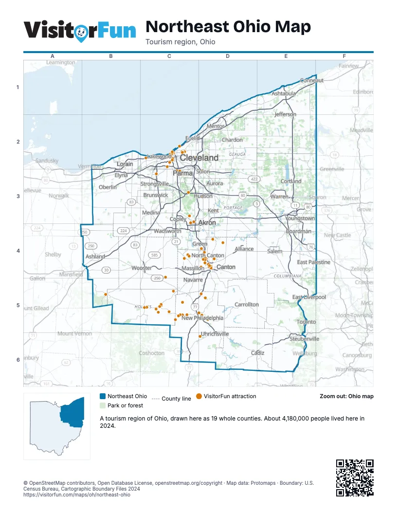
Highway index of Northeast Ohio
Each highway on the sheet and the grid squares it crosses.
- I-71B4, C2, C3, C4
- I-76C4, D3, D4, E3, E4, F4
- I-77C2, C3, C4, C5, C6, D4, D5
- I-80B3, C3, D3, E3, F3
- I-90B2, B3, C2, D1, D2, E1
- I-271C2, C3, D2
- I-277C4
- I-480B3, C2, C3, D3
- I-480NC2
- I-490C2
- I-680E3, E4
- US 6C2
- US 20B3, C2
- US 22D6, E6
- US 30B4, C4, D4, D5, E4, E5
- US 36C6, D5, D6
- US 42B4, C3
- US 62C4, D4, E3, E4, F3
- US 224B4, C4, D4, E4
- US 250B4, C4, C5, D5, D6, E6
- US 422C2, D2, D3, E3
- SR 2B2, B3, C2, D1, D2
- SR 3B4, B5, C3, C4
- SR 5D3, E3
- SR 7E3, E5, E6
- SR 8C3, C4, D3
- SR 10B3, C2
- SR 11E1, E2, E3, E4, E5
- SR 14C3, D3, E4, F4
- SR 18C3
- SR 21C3, C4
- SR 39B5, E5
- SR 44D2, D3, D4
- SR 46E4
- SR 57B2, B3, C3, C4
- SR 59C3, C4, D3
- SR 60B4, B5
- SR 82E3, F3
- SR 83B3, B4, C4
- SR 113B3
- SR 165E4
- SR 173D4, E4
- SR 176C2
- SR 283C2
- SR 301B3
- SR 585C4
- SR 711E3
- SR 800D5, D6
Things to do on the Northeast Ohio map
- 'Tis the Season
- A Christmas Story House & Museum
- Age of Steam Roundhouse Museum
- Akron Zoo
- Amish & Mennonite Heritage Center
- B.A. Sweetie Candy Company
- Belden Village Mall
- Bender's Tavern
- Best Western Plus North Canton Inn & Suites
- Broad Run Corner
- Brookside Furniture Woodcrafts
- Canton Classic Car Museum
- Canton Memorial Civic Center
- Canton Museum of Art
- Canton Palace Theatre
- Clay's Resort Jellystone Park
- Cleveland Botanical Garden
- Cleveland History Center
- Cleveland Lakefront Nature Preserve
- Cleveland Metroparks Zoo
- Cleveland Museum of Art
- Cleveland Museum of Natural History
- Coblentz Leather
- Comfort Inn Cleveland Airport
- Comfort Inn Downtown
- Comfort Inn Hall of Fame
- Comfort Suites Hartville
- Common Ground Canopy Tour
- Cuyahoga Valley National Park
- Cuyahoga Valley Scenic Railroad
- Dave & Buster's Westlake - Cleveland
- DoubleTree by Hilton Canton Downtown
- Downtown Akron Partnership
- Drury Plaza Hotel Cleveland Downtown
- Dutch Valley Restaurant & Bakery
- Embassy Suites by Hilton Akron Canton Airport
- Erb's Coleman Museum
- First & Main Hudson
- First Ladies National Historic Site
- Fort Laurens Museum
- Gervasi Vineyard
- Goodtime III Sightseeing Cruise
- Great Lakes Brewing Company
- Great Lakes Science Center
- Greater Cleveland Aquarium
- Gregory's Family Restaurant
- Guggisberg Cheese
- Guggisberg Swiss Inn
- Hall of Fame Village
- Hampton Inn & Suites Canton
- Hartville Kitchen Restaurant & Bakery
- Hartville MarketPlace & Flea Market
- Hatchet Club
- Heini's Cheese Chalet
- Hershberger's Farm & Bakery
- Historic Zoar Village
- Hochstetler Log Homes
- Hyatt Place Canton
- J.E. Reeves Victorian Home
- Kauffman's Country Bakery
- Keim
- Lady Caroline
- Lady Caroline Cruises
- Lake View Cemetery
- Lehman's Hardware
- Maize Valley Winery & Craft Brewery
- Maltz Museum of Jewish Heritage
- MAPS Air Museum
- Massillon Museum
- McKinley Presidential Library & Museum
- Miller's Dry Goods
- Miller's Rustic Furniture
- Museum of Contemporary Art Cleveland (moCa)
- Muskingum Watershed Conservancy District
- Ohio Swiss Festival
- Playhouse Square
- Pleasant View Furniture
- Portage County, OH
- Pro Football Hall of Fame
- Ramada by Wyndham Cleveland Independence
- Rock & Roll Hall of Fame
- Severance Music Center
- Sir Troy's Toy Kingdom
- Sky Zone Belden Village
- Sluggers & Putters
- Sluggers & Putters Amusement Park
- Stan Hywet Hall & Gardens
- Stark Parks
- Steelyard Commons
- Taggarts Ice Cream
- The Arcade Cleveland
- The Funny Bus Cleveland
- The Pottery Niche
- Troyer's Amish Tours
- Trumbull County, OH
- Trumpet in the Land
- USS Cod Submarine Memorial
- Walnut Creek Cheese & Market
- West Side Market
- Wingate by Wyndham Canton/Hall of Fame
Places on the map
- Akron
- Alliance
- Ashland
- Ashtabula
- Aurora
- Boardman
- Brunswick
- Cadiz
- Canton
- Carrollton
- Chardon
- Cleveland
- Conneaut
- Copley
- Cortland
- East Liverpool
- East Palestine
- Elyria
- Euclid
- Green
- Hudson
- Jefferson
- Kent
- Lakewood
- Lorain
- Massillon
- Medina
- Mentor
- Navarre
- New Philadelphia
- North Canton
- Oberlin
- Parma
- Salem
- Solon
- Steubenville
- Strongsville
- Toronto
- Uhrichsville
- Wadsworth
- Warren
- Wooster
- Youngstown
Next to Northeast Ohio
- Central Ohio map
- Northwest Ohio map
- Southeast Ohio map
- Great Lakes Region
- Pittsburgh & Its Countryside
- Northern Panhandle
© OpenStreetMap contributors, Open Database License, openstreetmap.org/copyright · Map data: Protomaps · Boundary: U.S. Census Bureau, Cartographic Boundary Files 2024