

Ohio map
Stark County map
About 374,091 people live here (Census Bureau, 2024 estimate). The sheet's index lists 182 streets; Ravenna Avenue Northeast, North Main Street and Cleveland Avenue Northwest cross the most grid squares. Things to do inside the boundary: Belden Village Mall, Bender's Tavern and Best Western Plus North Canton Inn & Suites.
Open the map (PDF, US Letter)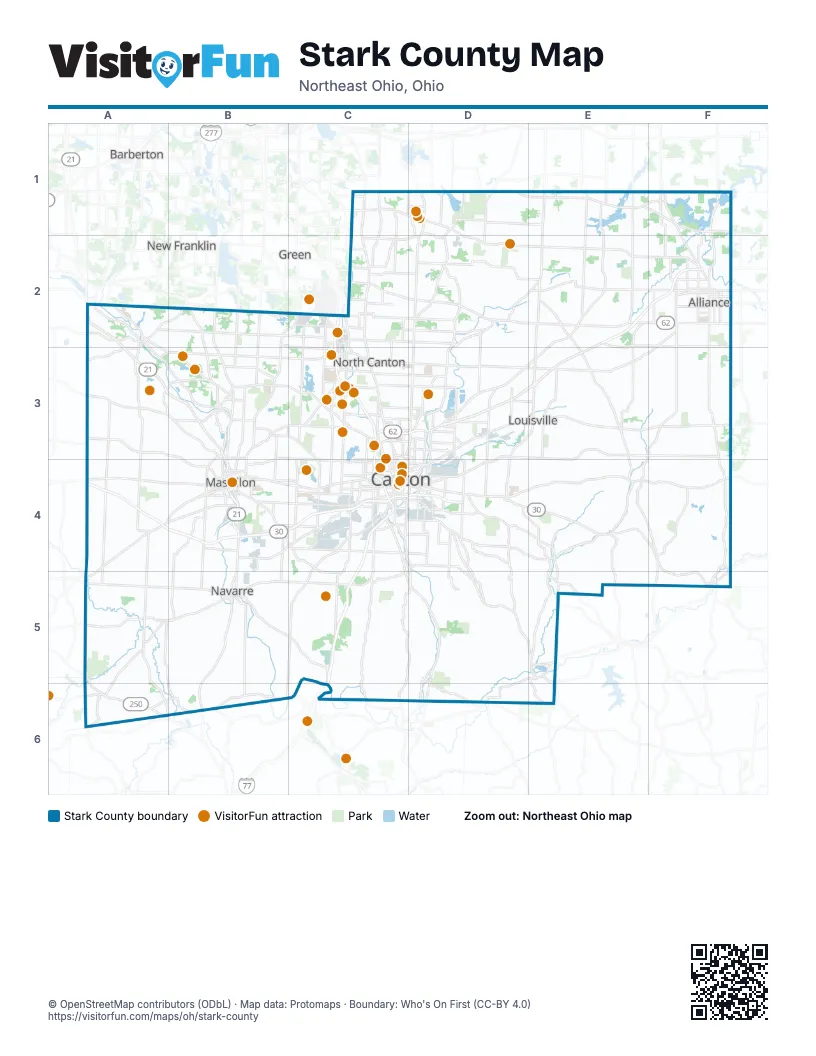
Street index of Stark County
Each street on the sheet and the grid squares it crosses.
- Cleveland Avenue NorthwestC1, C2, C3, C4
- East Turkeyfoot Lake RoadC1
- Edison Street NorthwestC1, D1
- East Maple StreetD1, C3, D3
- Edison Street NortheastD1, D2, E2, F2
- Kent Avenue NortheastD1, D2
- Market Avenue NorthD1, D2, C3, D3
- Market Avenue NortheastD1
- Market Avenue SouthwestD1
- South Prospect AvenueD1, D2
- West Maple StreetD1
- Ravenna Avenue NortheastE1, E2, D3, E3, D4
- Iowa Avenue NortheastF1, F2
- Union Avenue NortheastF1, F2, F3, F4
- Canal Street NorthwestA2
- Canal Street SouthA2, A3
- Cherry Street EastA2
- Cherry Street WestA2
- East Market StreetA2
- Erie Avenue NorthwestA2, A3, B3
- Great Lakes BoulevardA2
- Great Lakes Boulevard NorthwestA2, A3, B3, B4
- High Street NortheastA2
- Locust Street SouthA2, A3, B3
- Manchester Avenue NorthwestA2, B2, A3, A4
- Milan Street SouthA2, A3
- Akron AvenueB2
- Akron Avenue NorthwestB2, B3
- High Mill Avenue NorthwestB2, B3
- Manchester RoadB2
- Wales Avenue NorthwestB2, C2, B3
- Applegrove Street NortheastC2
- Applegrove Street NorthwestC2, D2
- Massillon RoadC2, A5
- North Main StreetC2, C3, B5, E5, D6
- Shuffel Street NorthwestC2
- State Street NorthwestC2, D2
- Whipple Avenue NorthwestC2, C3, C4
- State Street NortheastD2, E2
- Atlantic Boulevard NortheastE2, F2, D3, E3
- West State StreetE2, F2
- Diehl CourtF2
- East State StreetF2
- Gaskill Drive NortheastF2
- North Union AvenueF2
- South Union AvenueF2
- Orrville Street NorthwestA3, B3
- 1st Street NortheastB3, B4
- 3rd Street NorthwestB3, B4
- Earl Road NorthwestB3
- Fulton Drive NorthwestB3
- Fulton Road NorthwestB3, C3, C4
- Hills and Dales Road NortheastB3
- Hills and Dales Road NorthwestB3, C3
- Lafayette Drive NorthwestB3
- Portage Street NorthwestB3, C3
- Revere Avenue NorthwestB3
- Wales Road NortheastB3, B4
- 30th Street NorthwestC3, D3
- Belden Village Street NorthwestC3
- Charlotte Street NorthwestC3
- Dressler Road NorthwestC3
- Everhard Road NorthwestC3
- Everhard Road SouthwestC3
- Harrison Avenue NorthwestC3, C4
- Malone Parkway NorthwestC3, D3
- Mercy Drive NorthwestC3, C4
- Park DriveC3
- South Main StreetC3, B5
- Strip Avenue NorthwestC3
- Walnut Avenue NortheastC3, C4
- 30th Street NortheastD3
- Cherry Avenue NortheastD3, C4, D4
- Columbus Road NortheastD3
- Easton Street NortheastD3, E3
- Harmont Avenue NortheastD3
- Louisville Street NortheastD3, E3, F3
- Mahoning Road NortheastD3, D4
- Malone Parkway NortheastD3
- Trump Avenue NortheastD3, D4
- West Main StreetD3, E3, A6
- East Main StreetE3, A6
- North Chapel StreetE3
- South Chapel StreetE3
- Barrs Street SouthwestA4
- Finefrock Road SouthwestA4, B4
- Lincoln Street WestA4, B4
- Manchester Avenue SouthwestA4, A5, A6
- Millersburg Road SouthwestA4, B4, A5
- Erie Avenue SouthwestB4, B5, B6
- Erie StreetB4
- Erie Street SouthB4
- Lake Avenue NorthwestB4
- Lillian Gish Boulevard SouthwestB4
- Lincoln Way EastB4, C4
- Lincoln Way NorthwestB4
- Lincoln Way WestB4
- Main Avenue WestB4
- Richville Drive SoutheastB4
- Richville Drive SouthwestB4, C4
- Walnut Road SoutheastB4
- Walnut Road SouthwestB4
- 11th Street SoutheastC4
- 12th Street NortheastC4, D4
- 12th Street NorthwestC4
- 13th Street NorthwestC4
- 5th Street NortheastC4, D4
- 5th Street NorthwestC4
- 6th Street NortheastC4, D4
- 6th Street NorthwestC4
- Bolivar Road SouthwestC4
- Cherry Avenue SoutheastC4
- Cleveland Avenue SouthwestC4, C5, D5
- Faircrest Street SouthwestC4
- Harrison Avenue SouthwestC4
- Lake Road Boulevard NorthwestC4
- Mc Kinley Avenue SouthwestC4
- Mc Kinley Cut Thru Avenue SouthwestC4
- McKinley Avenue NorthwestC4
- McKinley Avenue SouthwestC4
- Raff Road SouthwestC4
- Tuscarawas Street EastC4, D4
- Tuscarawas Street WestC4
- Walnut Avenue SoutheastC4
- Wertz Avenue NorthwestC4
- 4th Street SoutheastD4
- 8th Street NortheastD4
- Belden Avenue SoutheastD4
- Cedar Street SouthD4
- East Nassau StreetD4
- East Walnut StreetD4
- Georgetown Street NortheastD4
- Lincoln Street EastD4
- Lincoln Street SoutheastD4, E4, F4, F5
- Lisbon Street NortheastD4, E4, F4
- Marion Motley Avenue NortheastD4
- Nassau StreetD4
- North Wood StreetD4
- Ravenna Avenue SoutheastD4, E4, E5
- Roshong Avenue SoutheastD4
- South Wood StreetD4
- Trump Avenue SoutheastD4
- Waynesburg Drive SoutheastD4, D5, E5
- West Nassau StreetD4
- Zwallen Way SoutheastD4, D5
- East Lincoln WayF4, F5
- Paris Avenue SoutheastF4
- Union Avenue SoutheastF4
- Dover RoadA5
- Navarre Road SouthwestA5, B5, A6
- Sandusky Drive SouthwestA5, A6
- Wabash Avenue NorthA5
- Wabash Avenue SouthA5
- West Canal StreetB5
- West Center StreetB5
- Cleveland Avenue SoutheastD5, D6
- Minerva Road SoutheastD5, E5, D6
- West Lisbon StreetD5, E5
- Zwallen WayD5
- Alliance Road NorthwestE5, D6
- Canal StreetE5
- Canton RoadE5
- East Lisbon CourtE5
- East Lisbon StreetE5
- Greer Avenue SoutheastE5
- Greer CourtE5
- Ross RoadE5, E6
- North Market StreetF5
- South Market StreetF5
- West Lincoln WayF5
- 3rd Avenue NorthwestA6
- 3rd Avenue SouthwestA6
- Dolphin Street SouthwestA6, B6, C6
- Maple StreetA6
- Massillon StreetA6
- Redwood Street SoutheastA6, B6
- Redwood Street SouthwestA6
- Winesburg StreetA6
- Amway Street SouthwestB6
- East Carrollton StreetD6
- Harrison StreetD6
- Waynesburg Road NorthwestE6
Things to do on the Stark County map
- Belden Village Mall
- Bender's Tavern
- Best Western Plus North Canton Inn & Suites
- Canton Classic Car Museum
- Canton Memorial Civic Center
- Canton Museum of Art
- Canton Palace Theatre
- Clay's Resort Jellystone Park
- Comfort Inn Hall of Fame
- Comfort Suites Hartville
- DoubleTree by Hilton Canton Downtown
- Embassy Suites by Hilton Akron Canton Airport
- First Ladies National Historic Site
- Gervasi Vineyard
- Gregory's Family Restaurant
- Hall of Fame Village
- Hampton Inn & Suites Canton
- Hartville Kitchen Restaurant & Bakery
- Hartville MarketPlace & Flea Market
- Hyatt Place Canton
- Maize Valley Winery & Craft Brewery
- Massillon Museum
- McKinley Presidential Library & Museum
- Pro Football Hall of Fame
- Sky Zone Belden Village
- Sluggers & Putters
- Sluggers & Putters Amusement Park
- Stark Parks
- Taggarts Ice Cream
- Wingate by Wyndham Canton/Hall of Fame
Places on the map
- Akron Children's Hospital at Aultman
- Alliance
- Alliance City Cemetery
- Alliance Country Club
- Alliance High School
- Alloway Meadows
- Amazon Fulfillment Center
- American Landfill
- Amesbury Hills
- Arrowhead Golf Club
- Auburn Knolls
- Avondale
- Avondale Arboretum
- Baylor Beach Park;Water Park & Campground
- Beach City
- Belden Park Crossings
- Belden Village Mall
- Bethlehem Township
- Bob-O-Link
- Brewster
- Brookside Country Club
- Butler Rodman Park
- Camp CHOF
- Canal Fulton
- Canton
- Canton Aggregate
- Canton Centre
- Canton Township
- Central High School
- Central-Allied Lake
- Clay's Resort Jellystone Park
- Clays Park Lake
- Clearview Golf Course
- Clearwater Park
- Colony Woods
- Congress Lake
- Congress Lake Golf Club
- Countywide Landfill
- Creekside Villas
Next to Stark County
- Barberton
- Green
- New Franklin
© OpenStreetMap contributors (ODbL) · Map data: Protomaps · Boundary: Who's On First (CC-BY 4.0)