

Texas map
San Antonio-New Braunfels Metro Area map
The sheet's index lists 15 highways; US 87, I-10 and US 90 cross the most grid squares. Things to do inside the boundary: Animal World & Snake Farm Zoo, Brackenridge Park and Buckhorn Saloon & Museum. Also on it: Bandera, Boerne and Bulverde.
Open the map (PDF, US Letter)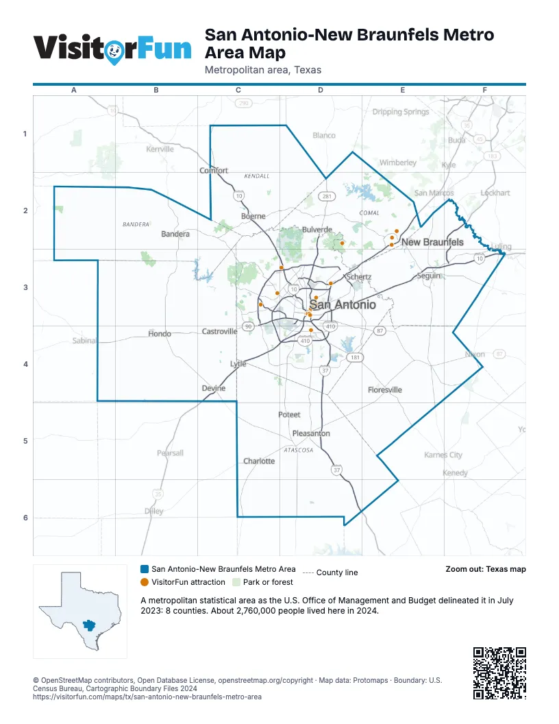
Highway index of San Antonio-New Braunfels Metro Area
Each highway on the sheet and the grid squares it crosses.
- I-10C1, C2, C3, D3, E3, F3
- I-35C4, D3, D4, E2, E3
- I-37D3, D4, D5, D6
- I-410C3, C4, D3, D4
- US 87C1, C2, C3, D3, D4, E4, F4
- US 90A4, B4, C3, C4, D3, E3
- US 181D4, E4, E5
- US 281D2, D3, D4, D5, D6
- TX 16C3, C4, D3, D4
- TX 97E4, F4
- TX 130D3, D4, E3, F2, F3
- TX 151C3, D3
- FM 462B4
- FM 471C4
- PA 1502D3
Things to do on the San Antonio-New Braunfels Metro Area map
- Animal World & Snake Farm Zoo
- Brackenridge Park
- Buckhorn Saloon & Museum
- Casa Catrina
- Casa Navarro State Historic Site
- Go Rio Cruises
- Gruene Hall
- Guadalupe River State Park
- Hill Country State Natural Area
- Historic Market Square (El Mercado)
- Hopscotch
- Japanese Tea Garden
- Landmark Inn State Historic Site
- LEGOLAND Discovery Center San Antonio
- Louis Tussaud's Waxworks
- Mad Dogs British Pub
- Majestic Theatre
- McNay Art Museum
- Morgan's Wonderland
- Natural Bridge Caverns
- Old Town Trolley Tours of San Antonio
- Old Tunnel State Park
- Rolling Oaks Mall
- Ruby City
- San Antonio Botanical Garden
- San Antonio Missions National Historical Park
- San Antonio Museum of Art
- San Antonio River Walk
- San Antonio Zoo
- Schlitterbahn Waterpark New Braunfels
- SeaWorld San Antonio
- Shops at Rivercenter
- Six Flags Fiesta Texas
- Spanish Governor's Palace
- The Alamo
- The Amazing Mirror Maze
- The DoSeum
- The Pearl
- The Saga at San Fernando Cathedral
- The Scream Experiment
- The Shops at La Cantera
- The Witte Museum
- Tower of the Americas
Places on the map
- Bandera
- Boerne
- Bulverde
- Castroville
- Charlotte
- Comfort
- Devine
- Floresville
- Hondo
- Lytle
- New Braunfels
- Pleasanton
- Poteet
- San Antonio
- Schertz
- Seguin
© OpenStreetMap contributors, Open Database License, openstreetmap.org/copyright · Map data: Protomaps · Boundary: U.S. Census Bureau, Cartographic Boundary Files 2024