

Alaska map
Fairbanks North Star Borough map
About 94,951 people live here (Census Bureau, 2024 estimate). The sheet's index lists 300 streets; Richardson Highway, Steese Highway and Chena Hot Springs Road cross the most grid squares. Things to do inside the boundary: Chena Hot Springs Resort and Santa Claus House.
Open the map (PDF, US Letter)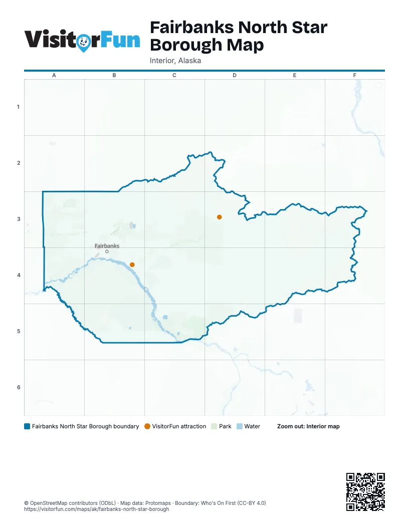
Street index of Fairbanks North Star Borough
Each street on the sheet and the grid squares it crosses.
- Richardson HighwayC3, C4, D4, D5, D6, E6, F6
- George Parks HighwayB3, C3, A4, B4
- Robert Mitchell ExpresswayC3, C4
- Chena Ridge Spur RoadC3
- Steese HighwayD1, E1, F1, C2, D2, C3
- Chena Hot Springs RoadF2, C3, D3, E3, F3
- Elliott HighwayB2, C2, C3
- Old Richardson HighwayC4, D4, D5, E6
- Badger RoadC3, C4, D4
- Airport WayC3, C4
- Goldstream RoadB3, C3
- Farmers Loop RoadC3
- Johansen ExpresswayC3
- Sheep Creek RoadB3, C3
- College RoadC3
- South Cushman StreetC3, C4
- University AvenueC3
- University Avenue SouthC4
- Geist RoadC3
- 30th AvenueC4
- South University AvenueC3, C4
- New Richardson HighwayC4
- Illinois StreetC3
- 28th AvenueC4
- Barnette StreetC3
- Cushman StreetC3
- Alumni DriveC3
- Badger Loop RoadC3
- North Cushman StreetC3
- Old Steese HighwayE1, C3
- Old Nenana HighwayB3, B4
- Chena Ridge RoadB3, C3, B4
- Laurance RoadD4
- Chena Pump RoadB3, C3, B4
- Peger RoadC3, C4
- River RoadC3, D3
- Gaffney RoadC3
- Ballaine RoadC3
- Van Horn RoadC4
- Montgomery RoadC3, C4
- Dawson RoadD4
- Lathrop StreetC3, C4
- Tanana LoopC3
- Saint Nicholas DriveD4
- 1st AvenueC3, C4, D4
- Meridian RoadC3, C4
- Cowles StreetC3
- West Trainor Gate RoadC3
- Noble StreetC3
- Minnie StreetC3
- Dartmouth DriveC3
- Buzby RoadD4
- West Tanana DriveC3
- 3rd StreetC3
- East 5th AvenueD4
- Trainor Gate RoadC3
- Thompson DriveC3
- West Cowles StreetC3
- North Santa Claus LaneD4
- South Santa Claus LaneD4
- Wendell AvenueC3
- Gilmore TrailC3
- Frontage RoadC4
- Cripple Creek RoadB4
- Bradway RoadC4
- Steele Creek RoadC3
- Holmes RoadC4
- Plack RoadD4
- Nordale RoadC3, C4
- Goldhill RoadB3, C3
- Flight Line AvenueD4
- Central AvenueC3, D4
- Birch Hill RoadC3
- Skyline DriveC3
- Nelson RoadD4
- McGrath RoadC3
- Phillips Field RoadC3
- Isberg RoadB4
- Repp RoadC4, D4
- Neely RoadC4
- Rosie Creek RoadB4
- Brock RoadC4
- 2nd AvenueC3, C4, D4
- Davis RoadC4
- Old Badger RoadC3, C4
- Dale RoadB4, C4
- Lakloey DriveC3, C4
- Summit DriveC3
- Mistletoe DriveD4
- Airport Perimeter RoadB4, C4
- North Nordale RoadC3
- Easy StreetC4
- Peede RoadC4
- Dennis RoadC4
- Old Chena Ridge RoadB3, C3, B4
- Macarthur StreetC4
- Lazelle RoadC3
- Aurora DriveC3, D4
- Airport Industrial RoadB4, C4
- Skyridge DriveC3
- D StreetC3
- Alder AvenueC4
- Roland RoadB4
- Lakeview DriveC4, D4
- Gillam WayC3, C4
- 10th AvenueC3
- Conifer DriveD4
- Merhar AvenueC3
- Kodiak StreetC3, D4
- Helmericks AvenueC3
- North Tanana DriveC3
- Homestead DriveC4
- Luzon AvenueC4
- Hollowell RoadD4
- East 8th AvenueD4
- Hagelbarger AvenueC3
- East Cowles StreetC3, C4
- Wilbur StreetC3, C4
- Mission RoadD4
- Bentley Trust RoadC3
- Fairbanks StreetC3
- 23rd AvenueC4
- 17th AvenueC3
- Danby StreetC3
- Rhineland AvenueC4
- Lyle AvenueD4
- Chena Small Tracts RoadC3
- Dyke RoadD4
- Birch LaneC3
- 21st AvenueC4
- City Lights BoulevardC3
- Ketcham RoadC3
- Farewell AvenueC3
- F StreetC3
- NPHS BoulevardC4, D4
- South Lathrop StreetC4
- North StreetD4
- Steelhead RoadC3
- Santiago AvenueC4
- Rozak RoadC4
- Western AvenueC3, C4
- 15th AvenueC3
- Hamilton AvenueC3
- East Van Horn RoadC4
- Inner LoopD4
- C StreetC3
- 6th StreetC4, D6
- Washington DriveC3
- Loftus RoadC3
- Rewak DriveC3
- Sportsman WayC3
- Herb Miller BoulevardC3
- Moore StreetC3
- Wembley AvenueC3
- Fairhill RoadC3
- Hunter StreetC3
- Kinney RoadC3
- Old Airport RoadC3, C4
- 10th StreetC3, C4
- 600th StreetC3, C4
- 17th Avenue ConnectorC3
- Old Chena Pump RoadC3
- Wien StreetC3
- Murphy Dome RoadA3, B3
- Old Murphy Dome RoadB3, C3
- Tanana LeveeB4, C4
- Quarry RoadD4, E4
- Skyline RoadD4, E4
- Johnson RoadE4, D5, E5
- Transmitter RoadD3, D4
- Fairbanks Creek RoadC2, D2
- Fish Creek RoadC2, C3, D3
- Trans Alaska Pipeline service roadD4
- Standard Creek RoadA4, B4
- Eielson Farm RoadD4, D5
- Cache Creek RoadB3
- Manchu RoadD4, E4
- Site RoadD2, D3
- Salcha DriveD5, E5, D6, E6
- Pipeline service roadC3, C4, D4
- Sled RoadA4
- Haystack DriveC2
- Dog Sled TrailA4, B4
- Ester Dome RoadB3
- U.S. Creek RoadE1
- Gold Mine TrailC3
- Hurst RoadC4, D4
- Himalaya RoadB2, C2
- Monzulla LaneC3
- Eielson POL Pipeline Service RoadD4
- Rosie Creek TrailB4
- Moose Mountain RoadB3
- Old Valdez TrailD5, D6
- Abraham RoadB3
- Fort Knox Mine Access RoadC2, C3, D3
- Airport Way Frontage RoadC3
- Saint Patrick RoadB3
- Esro RoadC3
- Pedro Dome RoadC2, C3
- Freeman RoadC3, D3
- Lakeview TerraceC4
- Tower RoadE4, E6
- Manchu Lake TrailD4
- East Ammo RoadC3
- Birch Hill LoopC3
- Grange Hall RoadD3
- Pheasant Farm RoadD3
- Bike PathD4
- Arctic AvenueD4
- Water Shed RoadC2
- Vault DriveC2, C3
- Woodcutting RoadD5
- Chena Point AvenueB4
- Pickering DriveB4
- Newby RoadD4
- Beacon RoadC3
- Wrong Way LaneD6, E6
- Ridgepointe DriveB4
- Persinger DriveC3, C4
- Ammo RoadC3
- Henderson Road NorthB3
- West Fork RoadF2
- Orchid DriveD5, D6
- Kallenberg RoadB4
- Ski Boot Hill RoadC3
- Lundeberg RoadC2
- High Sierra DriveB3
- Parks Ridge RoadB4
- Canaday RoadD5
- 2 Rivers RdD3
- Tungsten TrailC3
- Silver Fox RoadC3
- Bluegrass DriveB4
- Leuthold Drive EastC2
- Blanket BoulevardD4
- Old Elliot HighwayC2
- Fort Knox Mine Acces Road.C2
- Smallwood TrailC3
- Leuthold Drive WestC2
- Reconstruction RoadB3
- Treasure StreetC2
- Cogan RoadC2
- Parham McCormick RoadD4
- Miller Hill RoadC3
- Chena Ester Ditch RoadB3
- Monteverde RoadB3
- Crestline DriveC3
- Mullins Pit RoadD4
- West Chena Hills DriveB4
- Old Site RoadD5
- Benn LaneC4
- Yankovich RoadC3
- Darling AvenueB3
- Woll RoadC4
- Coyote TrailB3
- East Birch Hill RoadC3
- Peridot StreetC4
- Alder Creek RoadD2
- Becker Ridge RoadB4
- 3rd AvenueC3, C4, D4
- Amanita RoadC3
- Hillary AvenueB4
- Camper Creek RoadD2
- Emancipation LaneB3
- Jones RoadB3
- Cranberry Ridge DriveC3
- Pandora DriveC3
- Bias DriveC3
- Bennett RoadC3
- Simpson WayC2
- Tria RoadC4
- Richard Berry DriveB3
- Eagle Ridge RoadC3
- 19th AvenueC3
- Fiddle WayB4
- Chief John DriveB4
- FairbankscreekD2
- Grenac RoadC3
- Appomattox RoadB3
- Henderson Road SouthB3
- Gordon RoadD4
- Willow RunC3
- French Creek DriveD4
- Miller Hill Ext RoadC3
- Snowy Owl LaneC3
- Canterbury DriveB3, B4
- Slater DriveC3
- Bullion DriveC3
- Williston WayB3
- Fabian DriveC3
- Riverview DriveC3
- Outside BoulevardD4
- Spinach Creek RoadB3
- Keeling RoadC3
- South Turner StreetC3, C4
- Wabash AvenueD4
- 9th AvenueC3, C4
- Spring Glade RoadC3
- West Float Pond RoadC4
- Brer LaneC2
Things to do on the Fairbanks North Star Borough map
Places on the map
- Ace Lake
- Alaskaland
- Badger
- Banner Creek Mine
- Behr Mine
- Birch Hill Recreation Area
- Birch Lake
- Blair Lakes
- Byers Island
- Camp Li-Wa
- Chatanika Gold Dredge
- Chena Bend Golf Course
- Chena Hot Springs Airport
- Chena Ridge
- Chena River Lakes Recreation Area
- Chena River Research Site
- Chena Slough
- Chena State Recreation Area
- Chinook Conservation Park
- Chisholm Lake
- Cleary Hill Mine
- Coal Ash Disposal Landfill
- College
- Cripple Creek Campground
- Cushman Lake
- Davidson Ditch Historical Site
- Eielson Air Force Base
- Ester
- Ester Dome
- Fairbanks
- Fairbanks / Chena River KOA
- Fairbanks Golf Course
- Fairbanks International Airport
- Fairbanks Yard
- Farmers Loop
- Fort Wainwright
- Goldstream Public Use Area
- Murphy Dome Air Force Station
- Tanana Valley State Forest
- Yukon Weapons Range
© OpenStreetMap contributors, Open Database License, openstreetmap.org/copyright · Map data: Protomaps · Boundary: Who's On First (CC-BY 4.0); Quattroshapes (CC BY 2.0)