

Arkansas map
Arkansas County map
About 16,050 people live here (Census Bureau, 2024 estimate). The sheet's index lists 300 streets; South Main Street, Gander Street Road and Smokehouse Hill/Escronges Lake Road cross the most grid squares. Things to do inside the boundary: Arkansas Post National Memorial.
Open the map (PDF, US Letter)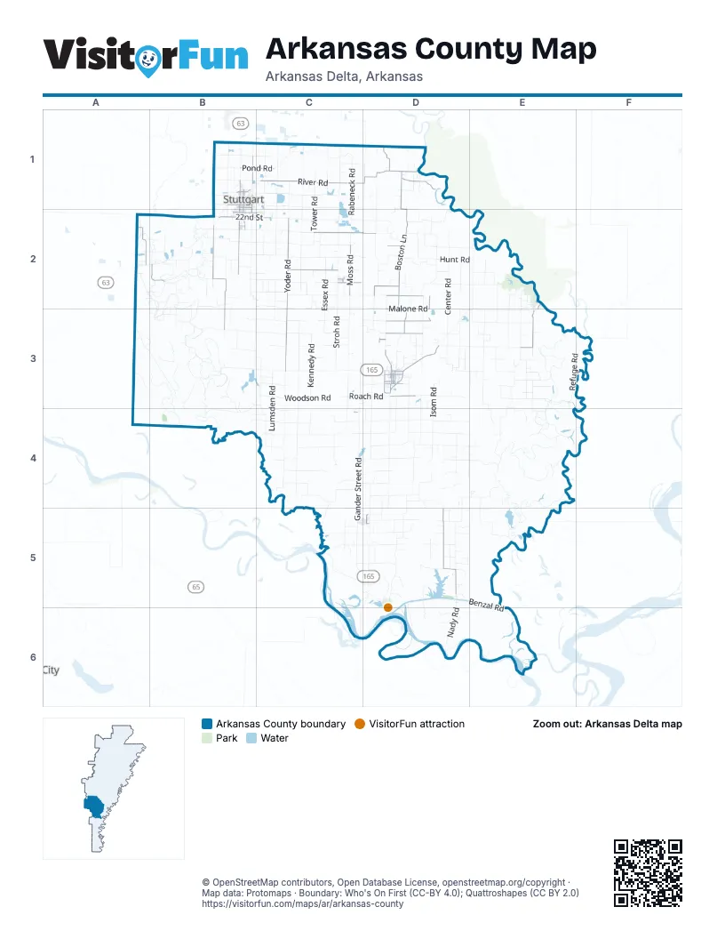
Street index of Arkansas County
Each street on the sheet and the grid squares it crosses.
- South Main StreetB1, A2, B2, D3
- North Whitehead StreetD3
- Pond RoadB1, C1
- McCoy RoadB1
- South Park AvenueB1, B2
- South Whitehead DriveD3
- North Buerkle StreetB1
- West 22nd StreetB2
- South Jackson StreetD3
- North FrontC2, D5
- North Main StreetB1, D3
- South Grandview DriveD3
- US Highway 79BB2
- GrandviewD3
- East Michigan StreetB1
- West Michigan StreetB1
- Ricebelt AvenueD3
- North Whitehead DriveD3
- North Grandview DriveD3
- North Park AvenueB1
- East Leslie AvenueD5
- 2nd StreetC1, E2
- Boston LaneD1, D2
- River RoadC1, D1
- State Highway 13A2
- East 22nd StreetB2, C2
- State Highway 152B2
- North Monroe StreetD3
- East 2nd StreetB1, D3
- West 2nd StreetB1, D3
- South Monroe StreetD3
- South Yoder RoadC2, C3
- Goldman Sunshine RoadB2, B3
- Tichnor Blacktop RoadD5
- South Buerkle RoadB2
- Malone RoadD2, D3
- Old Highway 17E3
- Almyra Airport RoadC2
- Moss RoadC2
- Elm Branch RoadD3
- Cooks Lake RoadD1
- Tarkington RoadC2, D2
- Murphy RoadD3
- Jack Hill RoadD2, D3
- Dewitt Airport RoadD3
- West 10th StreetB1, D3
- Knoll RoadD2
- Needmore RoadD2
- U & A RoadC2
- South Buerkle StreetB1, B2
- West 13th StreetB1, D3
- East 13th StreetB1, D3
- Voss RoadC2
- East 19th StreetB2, C2
- Howell RoadD2
- Mannis Horton RoadD2
- South Jefferson StreetD3
- Division StreetA2
- West 19th StreetB2
- East 10th StreetB1, D3
- Blant Hurt RoadD2
- East Maxwell AvenueD3
- Belnap AvenueE2, E3
- Paul Davis LaneD3
- West 14thC2
- West MainC2
- Roy Black LaneD3
- West Maxwell AvenueD3
- Golden Sunshine RoadB2
- East 14thC2
- West 2nd ExtensionB1
- South ColumbiaC2
- Gander Street RoadC3, C4, C5, D5
- Refuge RoadE3, F3
- Old Post RoadD5, D6
- Center RoadD2, D3
- Smokehouse Hill/Escronges Lake RoadE3, E4, F4
- Alcorn Gill RoadA2, B2, B3
- Wilbur D Mills RoadD5, D6
- Lumsden RoadC3, C4
- Stroh RoadC2, C3
- Essex RoadC2, C3
- Burks Switch RoadC2, C3
- Ethel RoadE3
- Benzal RoadD5, E5, E6
- Cullipher RoadE3, E4
- Bob Davis RoadC2
- Medina RoadD6, E6
- Bell RoadC4
- Synco LaneB2, B3
- North Forks Lagrue RoadD2, D3
- Nady RoadD5, D6
- Tower RoadC1, C2
- Senning LoopB2
- Possum Waller RoadD3, E3
- Rodgers RoadB4, C4
- Boonehill RoadD2
- Jacks Bay RoadE5
- Brewer RoadB3, B4
- Deberry Levee RoadE3
- Lester M RoadD4
- Vallier RoadB3
- Simon Fuhrman RoadC5
- Stamps Drier RoadC3, C4
- Garot RoadD3, D4
- Hesser Levee RoadD4
- Wallworth RoadC1
- Eldridge RoadC3
- Rieger RoadB2, C2
- Kagebein-Raabe RoadC2
- Holdridge RoadC2
- Roach RoadC3, D3
- Whitmore RoadE3
- Woodrow T RoadD5
- Isom RoadD3, D4
- Lafargue RoadD4
- Gray Reinhart RoadB1, C1
- Lodges Corner RoadB3, C3
- Belleview RoadE3
- East Woodson RoadC3
- Mitchell RoadD1, D2
- Leder RoadC1
- Carol-Don RoadD3, D4
- Widener RoadD2, E2
- Whiting LaneD5
- Graves RoadD2
- Drier RoadC4, D4
- Cox Cypress RoadB3
- Lost Island RoadC1
- Roth Prairie RoadB2
- Bradford RoadD2
- Stratton RoadC2, C3
- Morgan Loop RoadE3, E4
- Rubach RoadC1
- Wilcox Acres RoadD2
- North Kennedy RoadC3
- Daugherty RoadD1, D2
- George RoadC1
- Stillwell School RoadB3
- Hartz Seed RoadB1, C1
- Shannon RoadC2
- North Henry West RoadE3
- Wittman RoadC2
- Long Point RoadC2
- Ricusky RoadB2, C2
- North Yoder RoadC1, C2
- Spicer RoadB2, C2
- Robert Bullock RoadC4
- Overton RoadC3, C4
- South Rabeneck RoadC1, C2
- Wheeler Lake RoadC4
- Pleasant Grove RoadE3
- Cobb RoadB2, C2
- Derrick RoadD4, E4
- C P Vittitow LaneD4, E4
- Hunt RoadD2, E2
- McAdams RoadD3
- Wild Goose LaneD5, E5
- Boyd RoadD3
- Little Texas LaneD4
- Forrest School RoadD2, D3
- Simpson LaneB4
- Gillett Cemetery RoadD5
- Sunny Side LaneD3
- Clear Point Brasko RoadB1
- Grand Lake LaneB3
- Bisswanger RoadE3, E4
- Doughboy RoadD4
- Hopewell RoadE2, E3
- McDougall RoadC2, C3
- Goetz-Hargrove RoadB3, C3
- Meins RoadC1, D1
- Artie Robinson RoadD4, D5
- Mud Island RoadB3, C3
- Devore RoadC4
- Pin Oak RoadD2, D3, E3
- Relyea RoadC3
- Clive Collier RoadC4, D4
- Boyd Miller LaneC4
- Weaver RoadC1, C2
- Cox's Bend LaneB2, B3
- Bennett RoadC2, D2
- Bitner LaneE4
- Oscar James RoadC4, D4
- Gregory Fischer RoadB2
- Scott Landleveler RoadD3
- Shepherd Point LaneE4
- Shirley Owens RoadD5
- Pipkin RoadD5
- Zada Simpson RoadC3
- Hoskyn RoadB1
- Berg LaneD2
- West Woodson RoadC3
- South Kennedy RoadC3
- Hammans-White RoadB2
- Sigle Swain RoadD4, D5
- Tedford Island RoadC5
- Fuller RoadC3
- Old England HighwayB1
- Gunnell RoadD2
- Goodwin RoadC2
- Slash RoadC2
- Hillman RoadC2
- North Stinking Bay RoadE2, E3
- Freeman RoadC3
- Slaughterhouse RoadB1
- Frownfelter RoadC3
- Big Section RoadC4
- Glenn-Don RoadC1, D1
- Hagler RoadB3, C3, B4
- John Black RoadD4
- McLain RoadD4
- Clyde-Fread RoadE3
- Grffie RoadD5
- Billy-James RoadD3, D4
- Charles Alter RoadD3, D4
- Hall RoadC3, D3
- Lowe RoadD5
- Tindall Dryer RoadB2, C2
- Robnett RoadC1, D1
- Anderson Bay LaneE2
- Stephens RoadC1, C2
- Lawson RoadD3
- Hasty LoopD2
- Grabbe RoadC1
- Irene RoadC2
- Dry Lake RoadE5
- Murl Long RoadD5
- Dupslaff RoadE3
- Eason RoadE2
- Porter RoadE3
- George Smith RoadE2
- Mary Louise RoadC3, D3
- Abramson RoadD3
- Hampton RoadC3, C4
- Sollars RoadC4
- Stoesvand LoopC1
- Van Camp RoadC4
- Childers Cemetery RoadD4
- Rising Sun RoadD2
- Hayes Lake LaneC5
- Owens LaneD1
- Adrian Mc LaneD5, D6
- Ross LaneC5, C6
- Pittman RoadD4
- O W LaneC4
- Sam Deberry RoadE2
- Thigpen RoadD3
- North Keaton Flats LaneD2
- Ryan RoadA2, B2
- Stewart RoadE3
- Osborne LaneB2
- Pampas LaneC4
- Longbell RoadA3
- Rylex RoadD5
- Hudson LaneD6
- Siems RoadC3
- Thompson Cemetery RoadD3
- Vice RoadC2
- Sexton LaneC4
- Coit LaneD2
- Waldo-Morgan LoopB3
- North Rabeneck RoadC1
- Henderson-Estates RoadD2
- Kline RoadD2
- Seemore RoadC2
- Ben Purdy RoadD4
- Townsend LaneB2
- Gill LaneB3
- New Cut RoadD1
- Greenhill LaneE4
- Jack Bay RoadD5, E5
- Holzhauer RoadD4, D5
- Phelps RoadB3, C3
- Sunny Side RoadD3
- V H Haynes LaneD5
- Padgett Levee RoadE3
- Ella LaneD2
- Gordon Loop RoadC5
- Mayview RoadD4
- Jones Lake RoadE3
- Don Lloyd RoadB2
- Wallace LaneC4, C5
- Fish Levee RoadD2
- Wilson LaneA2, B2
- Carver LoopE3
- Randolph LaneB2
- New Zion RoadD5
- L R Shannon LaneB2
- Trussell LaneD4, E4
- Washington StreetB1, E2
- Flag Lake LaneC4, C5
- J R Johnson RoadB1, B2
- Wolf RoadC3
- Sebree RoadC2
- County Line RoadC1
- Wildlife Farms LaneD1
- Benson Camp LaneB3
- Billy Cotten LaneD4
- Browder RoadB3
Things to do on the Arkansas County map
Places on the map
- Almyra
- Almyra Municipal Airport
- Almyra Post Office
- Arkansas Post National Memorial
- Bayou
- Bear Lake
- Burnt Lake
- Cain Park
- Covington Lake
- Crocketts Bluff Post Office
- Daugherty Reservoir
- De Witt Cemetery
- De Witt Municipal Airport
- DeWitt
- DeWitt City Park
- Eason Lake
- Escronges Lake
- Essex Bayou
- Gillett
- Gum Pond
- Humphrey
- John Smith Lake
- Knoff Reservoir
- La Grues Lake
- Little White Lake
- Lone Tree Cemetery
- Lower White Lake Lake
- McCracken Lake
- Otter Lake
- Owens Lake
- Payer Lake Number One
- Pike Pond
- Rodgers Lake Number One
- Saint Charles
- Scroggins Reservoir
- Southern Lake
- Stuttgart
- Stuttgart Country Club
- U.S. Army Corps of Engineers
- Walworth Reservoir
© OpenStreetMap contributors, Open Database License, openstreetmap.org/copyright · Map data: Protomaps · Boundary: Who's On First (CC-BY 4.0); Quattroshapes (CC BY 2.0)















