

Arizona map
Apache Junction map
About 44,309 people live here (Census Bureau, 2024 estimate). The sheet's index lists 300 streets; Superstition Freeway, North Apache Trail and South Ironwood Drive cross the most grid squares. Things to do inside the boundary: Apache Trail Tours, Dolly Steamboat and Yak N Sup.
Open the map (PDF, US Letter)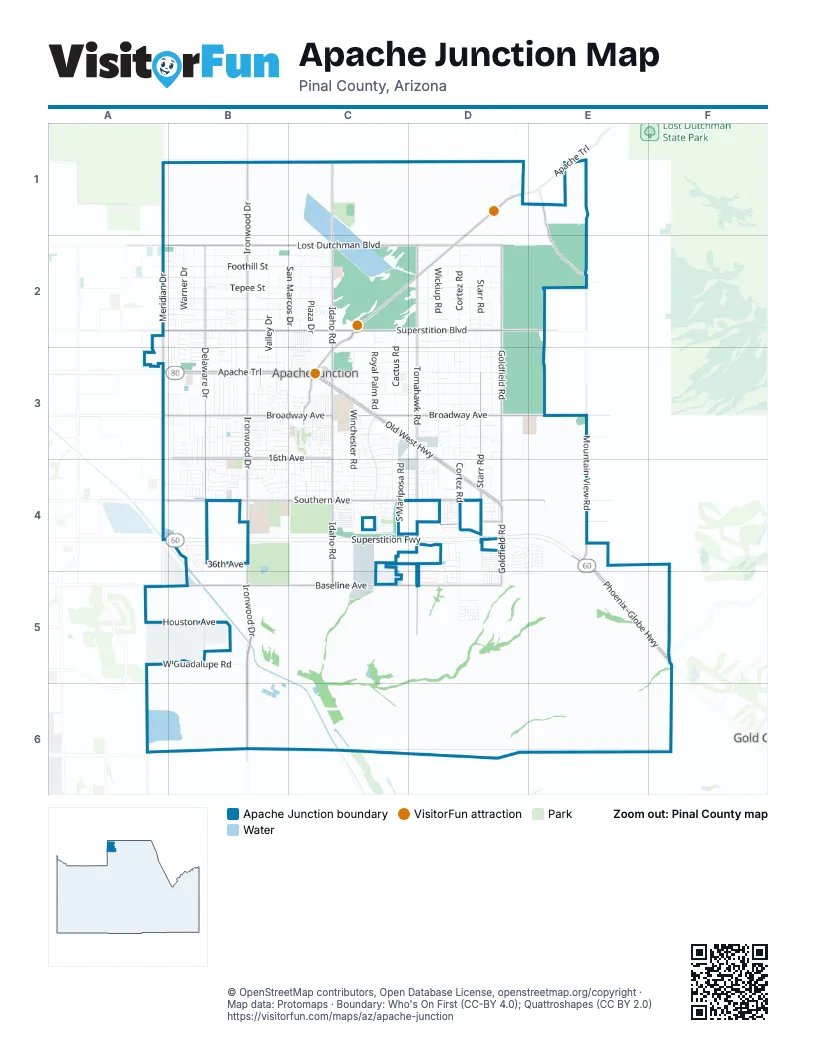
Street index of Apache Junction
Each street on the sheet and the grid squares it crosses.
- Superstition FreewayA4, B4, C4, D4, E4
- South Ironwood DriveB3, B4, B5, B6
- East Old West HighwayC3, D3, D4
- West Apache TrailA3, B3, C3
- Phoenix–Globe HighwayE4, E5, F5
- South Goldfield RoadD3, D4, D5
- West Baseline AvenueB5, C5
- West Old West HighwayC3
- North Apache TrailD1, E1, C2, D2, C3
- South Idaho RoadC3, C4, C5
- East Broadway AvenueC3, D3, E3
- East Superstition BoulevardC2, D2, E2
- North Idaho RoadC1, C2, C3
- North Ironwood DriveB1, B2, B3
- South Tomahawk RoadD3, D4, D5
- East Southern AvenueC4, D4, E4
- East Lost Dutchman BoulevardC2, D2
- South Mountain View RoadE3, E4
- East Baseline AvenueC5, D5
- West Superstition BoulevardA2, B2, C2
- West Broadway AvenueB3, C3
- West Southern AvenueB4, C4
- North Tomahawk RoadD2, D3
- North Goldfield RoadD2, D3
- South Meridian DriveA4
- West Lost Dutchman BoulevardA2, B2, C2
- West 16th AvenueB3, C3
- South Delaware DriveB3, B4, B5
- South Starr RoadD3, D4
- North Mountain View RoadE1, E2
- North Delaware DriveB2, B3
- North Meridian DriveA2, A3
- East 28th AvenueD4, E4
- South Phelps DriveC3
- East Brown RoadA2
- South Superstition Mountain DriveF5
- Delaware DriveB3
- South Royal Palm RoadC3, C4, C5
- South Cortez RoadD3, D4, D5
- South Winchester RoadC3, C4, C5
- East Junction StreetC3, D3
- West Tepee StreetB2, C2
- West Foothill StreetA2, B2, C2
- East Scenic StreetC3, D3
- East 4th AvenueC3, D3, E3
- West Shiprock StreetA2, B2, C2
- West Windsong StreetA2, B2, C2
- West Roundup StreetB2, C2
- South Cactus RoadC3, C4, C5
- North Valley DriveB2, B3
- North Cortez RoadD2, D3
- South Wickiup RoadD3, D4, D5
- East 12th AvenueC3, D3, E3
- Kiowa CircleC3
- West Smoketree StreetB2, C2
- South Desert View DriveB3, B4, B5
- North Starr RoadD2, D3
- South Warner DriveB3, B4, B5
- North Vista RoadD2, D3
- South Palo Verde DriveB3, B4
- North Plaza DriveC2, C3
- North San Marcos DriveC2
- East 2nd AvenueC3, D3
- West Guadalupe RoadA5, B5
- East Tepee StreetC2, D2
- North Hilton RoadD2, D3
- South Ocotillo DriveB3, B4
- West 12th AvenueB3, C3
- North Wickiup RoadD2, D3
- South Main DriveB3, B4
- West Greasewood StreetB2, C2
- West Houston AvenueB5
- South San Marcos DriveC3, C4
- Klamath AvenueC3
- South Saguaro DriveB3, B4
- South Hilton RoadD3, D4
- South Grand DriveB3, B4
- South Thunderbird DriveB3, B4
- North Acacia RoadD2, D3
- West 20th AvenueB4, C4
- West 17th AvenueB4, C4
- East 10th AvenueC3, D3, E3
- North Warner DriveB2
- South Vista RoadD3, D4
- West 21st AvenueB4, C4
- East 16th AvenueC3, D3, E3, D4
- West 22nd AvenueB4, C4
- West 18th AvenueB4, C4
- South Chaparral RoadD3, D4, D5
- West 13th AvenueB3, C3
- North Main DriveB2
- South Conestoga RoadD3, D4, D5
- South Acacia RoadD3, D4
- West 5th AvenueA3, B3, C3
- South Cedar DriveB3, B4
- East 20th AvenueC4, D4, E4
- East Foothill StreetD2
- North Thunderbird DriveB2, B3
- South Lawson DriveB3, B4
- North Gold DriveB2, B3
- South Mariposa RoadC4
- East 18th AvenueC4, D4, E4
- South Valley DriveB3, B4
- South Gold DriveB3
- South Bowman RoadD3, D4, D5
- South Colt RoadC3, C4, C5
- South Lawther DriveB3, B4
- South Buena Vista DriveC3, C4
- South Arroya RoadE3, E4
- North Desert View DriveB2
- West 14th AvenueB3, C3
- West 4th AvenueA3, B3
- West 15th AvenueB3, C3
- North Grand DriveB2
- North Saguaro DriveB2, B3
- East Mesquite AvenueC4, D4
- West Virginia StreetB2, C2, B3
- East Cody StreetC2, D2
- South Descanso RoadD3, D4, D5
- North Ocotillo DriveB2, B3
- West 23rd AvenueB4, C4
- North Monterey DriveC2
- East 38th AvenueC5, D5
- South Stardust DriveB3, B4
- East Jacob Waltz StreetE1
- West Gregory StreetA3, B3
- North Arroyo RoadE2
- West Primrose LaneA4, B4
- South Cardinal DriveB3, B4
- West 15th LaneB3, C3
- North Cedar DriveB2
- South Coconino DriveC3, C4
- North Nodak RoadE1
- West Renaissance AvenueB4
- ToscanaD4, E4
- East 6th AvenueC3, D3
- East Yuma AvenueC4, D4
- West 36th AvenueB4
- South Pennsylvania AvenueD3
- South Silver DriveB3, B4
- North Rennick DriveB2, B3
- Hackamore RoadD1
- North Palo Verde DriveB2, B3
- South Apache DriveC3, C4
- North Cactus RoadC2, C3
- North Royal Palm RoadC2, C3
- East 19th AvenueC4, D4
- East 39th AvenueC5, D5
- East 14th AvenueC3, D3, E3
- South Arizona RoadC3, C4
- South Silly Mountain RoadE4, E5
- East Pima AvenueC4, D4
- East 7th AvenueD3
- East Hondo AvenueC3
- East Roosevelt StreetC3, D3
- East Kachina AvenueC4
- East Osage AvenueC4
- East 37th AvenueD4, C5, D5
- East Linda AvenueC4
- East Navajo AvenueC4
- East 36th AvenueC4, D4, E4
- East 22nd AvenueC4, D4, E4
- East 29th AvenueC4, D4
- South Mara DriveB3, B4
- West 19th AvenueB4, C4
- West Rambling Rose LaneA4, B4
- West Wild Rose LaneA4, B4
- West Roosevelt StreetB3
- South Pinal DriveB3, B4, A5
- North Apache DriveC2
- East Mohave LaneC4, D4
- West Ohio StreetB2
- East Friar AvenueC3
- South Belair RoadC3, C4
- West Manzanita StreetA2, B2
- West 11th AvenueB3, C3
- East Pioneer StreetD2, E2
- South Vaquero RoadD3, D4
- South Iron Ore DriveD4, D5
- West Mockingbird StreetB2
- Seminole DriveC3
- West Cactus Wren StreetB3
- North Pinal DriveB2, B3
- Amore LaneD4, E4
- West Mesquite AvenueB4
- East Greasewood StreetD2
- Sorriso LaneD4, E4
- South Weaver DriveB3, B4
- West Diamond AvenueB4
- East 26th AvenueC4, E4
- East Greenlee AvenueC4, D4
- CactusC2, C3, C4
- East 9th AvenueC3, D3
- South Mineshaft DriveD4, D5
- East Estevan AvenueC3
- East Desert AvenueC3
- Dutchman BoulevardC2, C3
- South Hale DriveB3, B4
- North Bowman RoadD2, D3
- West Rosal AvenueB3, C3
- Amelia EarhartC4
- South Desert View PlaceB3, B4
- East Mining Camp StreetD1, E1
- East 17th AvenueC4, D4
- South Old Ironwood DriveB5
- West 9th AvenueB3, C3
- Candela LaneD4, E4
- Bella LaneD4, D5, E5
- North Pinyon DriveB2, B3
- West 10th AvenueB3, C3
- South Copper DriveB3
- East 21st AvenueC4, D4
- Zuni DriveC3
- West Cholla StreetB2
- OcotilloC3, C4
- South Smythe DriveA3, B3
- South Sunrise DriveB4
- DesertC2, C3, C4
- South Stagecoach RoadD3, D4
- East 27th AvenueC4, D4
- West Primrose DriveB4
- East McKellips BoulevardE1
- East 15th AvenueD3
- South Padre RoadC3, C5
- Resort BoulevardD4
- South Monterey DriveC3, C4
- South Plaza DriveC3, C4
- West Nugget DriveB4
- South Papago DriveC3, C4
- East Granada AvenueC3
- East Shiprock StreetD2
- South Outpost RoadC3
- West Villa StreetC2
- East Montebello AvenueC4
- Paiute AvenueC3
- West 7th AvenueB3
- East Peppertree AvenueC4
- South Pinto DriveB3, B4
- South Rennick DriveB4
- West Canterbury Bell BoulevardB4
- West Cody StreetB2
- East Quail AvenueC4
- South Powell RoadD4
- South Belaire RoadC3
- North Winchester RoadC3
- South Raindance RoadD4
- East Manzanita StreetD2
- East Needle Canyon AvenueD5
- Chippewa AvenueC3
- North ViewB3
- JavelinaC4
- South Rock Hound DriveD4
- 3rd AvenueC3
- 4th AvenueC3
- 5th AvenueC3
- 1st AvenueC3
- 2nd AvenueC3
- 8th AvenueC3
- 9th AvenueC3
- East Mother Lode DriveD4
- ButteC2, C3
- 3rd StreetC3
- South Davis Drive WestB4
- South Fork LaneC3
- Divino LaneD5, E5
- East Houston AvenueD5
- East Barnacle AvenueD5
- 10th AvenueC3
- 11th AvenueC3
- South Del Rio DriveC4
- South Bougainvillea DriveB4
- West Rosa StreetC2
- North AvenueB3
- ApacheC2, C3
- East Nightdigger DriveD5
- South de Niza RoadC3, C5
- East Santa Cruz LaneC4
- EagleC2, C3
- East 34th AvenueC4, E4
- Caleen DriveC3
- Church DriveC3
- East Hawk's Eye DriveD4
- East Ironstone DriveD4
- East Cinnebar DriveD4
- East Diamond DriveD4
- East Emerald DriveD4
- East Felspar DriveD4
- East Gypsum DriveD4
- East Jasper DriveD4
- Red RockC4
- East Boulder AvenueD5
- East 32nd AvenueD4, E4
- South Nickel DriveD4, D5
- CoyoteC4
- East La Casa DriveC4
- Fontana WayD4, D5
- South Oleander DriveB4
- CanyonC4
- East Music Mountain AvenueD5
- West 14th PlaceB3
Things to do on the Apache Junction map
Places on the map
- 8th fairway (part 1)
- AJUSD School Bus Depot
- Apache Creek Golf Club
- Apache Greyhound Park
- Apache Junction Auto Center
- Apache Junction Christian Community Church
- Apache Junction City Hall
- Apache Junction Health Center
- Apache Junction High School
- Apache Junction Landfill
- Apache Junction Medical Plaza
- Apache Junction Municipal Court
- Apache Junction Police Department
- Apache Junction Post Office
- Apache Junction Public Library
- Apache Junction RV Service & Supply
- Apache Junction Seventh-day Adventist Church
- Apache Junction Tires & Service
- Apache Trail Auto Supply
- Apache Trail High School
- Arizona Desert Star Automotive
- Arizona Diagnostic Radiology
- Arizona Kawasaki
- Arizona Vedic Cultural Center
- Arroyo Hermoso Mexican Village
- Aurora House
- Desert Vista Elementary School
- KOA Kampground
- Old West Marketplace
- Postal Depot
- Prospector Park
- Roadhaven Resort
- Rodeo Park Event Center
- Silly Mountain
- Siphon Draw Basin
- SMFD Regional Training Center
- Snakehole Golf & Country Club
- Superstition Plaza
- Superstition Shadows Park
© OpenStreetMap contributors, Open Database License, openstreetmap.org/copyright · Map data: Protomaps · Boundary: Who's On First (CC-BY 4.0); Quattroshapes (CC BY 2.0)















