

Arizona map
Eloy map
About 19,199 people live here (Census Bureau, 2024 estimate). The sheet's index lists 300 streets; Casa Grande–Tucson Highway, South Curry Road and South Tweedy Road cross the most grid squares. Things to do inside the boundary: Skydive Arizona.
Open the map (PDF, US Letter)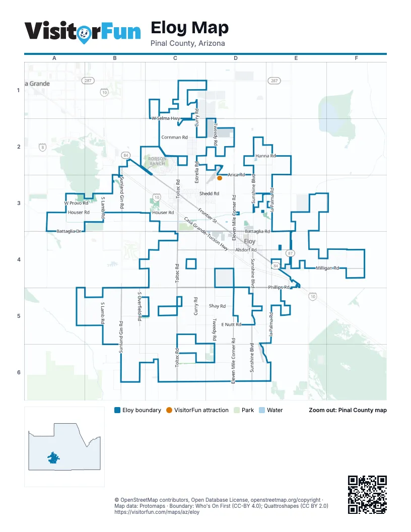
Street index of Eloy
Each street on the sheet and the grid squares it crosses.
- Casa Grande–Tucson HighwayB2, B3, C3, C4, D4, E4
- West Frontier StreetC2, C3, D3, D4
- Junction I-10–Mesa HighwayE2, E3, E4
- East Frontier StreetD4, E4
- North Eleven Mile Corner RoadD3, D4
- Casa Grande la Palma HighwayC1
- West Casa Grande-Picacho HighwayD4
- South Sunshine BoulevardD4, D5, D6
- South Sunland Gin RoadB3, B5, B6
- West Battaglia RoadC3, D3, C4, D4
- West Battaglia DriveA4, C4
- North Sunland Gin RoadB2, B3
- East Alsdorf RoadD4, E4
- North Main StreetD4
- South Main StreetD4
- South Toltec RoadC4, C5, C6
- East Phillips RoadC4, D4, E4
- Eleven Mile Corner RoadD2, D3, D4, D5
- South Eleven Mile Corner RoadD2, D4, D5, D6
- North Toltec RoadC2, C3, C4
- East Milligan RoadE4, F4
- West Alsdorf RoadC4, D4
- South Overfield RoadB2, B4, B5, B6
- West Selma HighwayC1, D1
- Robson BoulevardC2
- East Battaglia RoadE3, D4, E4
- Club House LoopC2
- East Camino AdelanteE4
- South Vail RoadE4
- West Houser RoadA3, B3, C3, D3
- South Curry RoadC1, C2, C4, C5, C6
- South la Palma RoadE2, E3, E4, E5
- West Shedd RoadA3, B3, C3, D3
- South Tweedy RoadD1, D2, D4, D5, D6
- North Estrella RoadC2, C3, C4
- North Sunshine BoulevardD2, D3, D4
- East Nutt RoadC5, D5, E5
- West Milligan RoadC4, D4
- South Lamb RoadB3, B5
- North Tumbleweed RoadD3, D4
- East Houser RoadD3, E3
- South Toltec Buttes RoadC2, C3, C4, C5, C6
- West Phillips RoadC4, B5, C5
- West Cornman RoadC2, D2
- West Shay RoadC5, D5
- West Hanna RoadC2, D2
- West Provo RoadA3, B3
- East Hanna RoadD2, E2
- Harris Hawk LaneB2, C2
- East Hauser RoadD3, E3
- Pretzer RoadD6
- West Harmon RoadD5, E5, B6
- East Date StreetD4, E4
- West Earley RoadC1
- Henness RoadA3
- South Signal Peak RoadC1
- East Arica RoadD2, E2
- West Phoenix AvenueD4
- Peart RoadA3, A4
- Shay RoadD5
- Tonto RoadC3, D3
- South Estrella RoadC6
- East Shedd RoadD3
- Valley RoadC2
- North San Juan RoadC2
- South Tumbleweed RoadD4
- North la Palma RoadE4
- West Arica RoadB2, D2, B3
- West Cameo RoadD5
- South John Jacob Astor AvenueB3
- Papago StreetC3
- West Acoma AvenueB2, D2
- North Washington StreetD3, D4
- East Battaglia DriveE3
- North Madison StreetD3, D4
- South D StreetD4
- North Curiel StreetD3, D4
- North Myers BoulevardD4
- North Tweedy RoadD2, D3, D4
- West Cherry Oaks DriveC2
- West Ropers RoadB2, C2
- Anasazi DriveC2
- North Santa Cruz AvenueD4
- North Zapotec AvenueC3
- Hotts RoadD6, E6
- West Tonto RoadC3
- East Shay RoadD5
- Wheeler RoadF4
- West Martin Luther King Junior StreetD4
- West Coolidge AvenueC3
- South Penn StreetD4
- West Posse DriveB2, C2
- North Kioha DriveC3
- North Oro DriveC3
- East Phoenix AvenueD4
- West 11th StreetD4
- West Outer DriveC3
- West Hanna DriveC2
- North Tryon AvenueD4
- North Rio DriveC3
- North Robson BoulevardC2
- North Valley RoadC3
- South Trekell RoadA3
- West 3rd PlaceD4
- West Shira StreetC3
- North D StreetD4
- West 1st StreetD4
- North Grande AvenueC3
- North Bandelier DriveD3
- North Algodon DriveD3
- North Juniper DriveD3
- North Mateo DriveD3
- North Kiami DriveC3
- North Hohokam DriveC3
- North San Carlos DriveC3
- North Taylor StreetD3
- Fairway DriveC3
- North Marshall DriveC2
- South Edgedale RoadE4
- West Hinton StreetD4
- North del Monte DriveC3
- West Pretzer RoadD6
- Nutt RoadD5, E5
- North Adams StreetD3, D4
- South Henness RoadA3
- South McClellan's RoadF4
- West Vaquero DriveC2
- West Mountain View AvenueB3
- West Solano DriveC2
- West Tollan DriveC2
- West Trona DriveC2
- North Curry RoadC1
- North Maya RoadD3
- West Madera DriveC2
- West Colusa DriveC2
- West Corridos DriveC2
- West Aztec DriveC2
- West Caballero DriveC2
- West Paraiso DriveC2
- West Quail RoadC2
- West Santan Vista DriveC2
- West Toluca DriveC2
- West 5th StreetD4
- West Cabra WayC4
- West Desierto DriveC2
- West Romana DriveC2
- West Sueno DriveC2
- West Aguadero DriveC2
- West Encanto DriveC2
- West Wupatki DriveC3
- East 5th StreetD4
- East 4th StreetD4
- West Chambers StreetD4
- East 3rd StreetD4
- South Margaret AvenueD2
- Curiel StreetD4
- Grand Canyon DriveC2
- North Lincoln StreetD4
- North Coyote Hill RoadC2
- West Gulch DriveC2
- West Pueblo DriveC2
- West 2nd PlaceD4
- North La Brea StreetC3
- West 4th StreetD4
- North Catalina DriveC3
- West Corral DriveC2
- West Agave AvenueC2
- North Toltec Buttes RoadC3
- North Stuart BoulevardD4
- West Clubhouse DriveC3
- North Scottsdale RoadC2, C3
- West Giles StreetC3
- Milligan RoadD4
- North Cocopa DriveD3
- West Buckskin DriveC2
- North la Paz DriveC3, D3
- West Tohono DriveC3
- North Mohu DriveD3
- North Arizona StreetC3
- West Hayden DriveC3
- North Maverick DriveC2, C3
- Carter LaneE4
- West 8th StreetD4
- North Monarch DriveC3
- West Cowboy TrailC3
- East 9th StreetD4
- West Walnut DriveC3
- East 6th StreetD4
- South Picacho Heights RoadD4
- East 1st StreetD4
- Summer RoadC4
- East Batten RoadE2
- West 13th StreetD4
- North Luna DriveB2, C2
- West 12th StreetD4
- North Comanche DriveC2
- West Winslow WayC2
- West Ironwood DriveC3
- West Saguaro DriveC3
- West 14th StreetD3
- West Adobe DriveC2
- West Cameron DriveC3
- Pueblo DriveC2
- West Gun Fury RoadC4
- North Palm CircleC3
- West 6th PlaceD4
- North Montgomery CircleC3
- West Picacho DriveC3
- East 2nd StreetD4
- Cortez DriveC3
- East 11th StreetD4
- North Dakota DriveC2
- Pioneer DriveC2
- Maricopa StreetC3
- South Senita StreetD2
- West 7th StreetD4
- West Aldrich AvenueC3
- North Davidson BoulevardD3, D4
- North Gila Trail DriveC2
- West Cheyenne DriveC2
- West Court DriveC3
- West White Horse BoulevardC2
- South Cox RoadB3
- North Montezuma DriveC3
- East Mohave CircleD4
- Buckskin DriveC2
- West Harris Hawk LaneC2
- North Manzanita AvenueC2
- East Hopi CircleD4
- East Navajo CircleD4
- North Turquoise DriveC3
- West Snowbird DriveC2
- West Lee StreetC3
- West Long DriveC3
- West Comanche DriveC2
- North Cameron DriveC3
- West Loma Verde AvenueC2
- North Tamarax DriveC3
- West Chippewa DriveC2
- North Lear DriveD3
- South Corder RoadC5
- East 10th StreetD4
- East 7th StreetD4
- East 8th StreetD4
- North Fawn StreetC3
- North Golden StreetC3
- West 9th StreetD4
- North Emerald StreetC3
- West 6th StreetD4
- North Apache DriveD4
- North A StreetD4
- West Grogan AvenueD2
- Nogales WayC2
- West Adams RoadB2
- East Blair RoadE2
- Gulch DriveC2
- West 10th StreetD4
- South Apache AvenueD4
- West Tortoise DriveC2
- Mohawk DriveC2
- West Miller RoadC3
- West la Siesta DriveD4
- North Oak Creek DriveC2
- South Ottawa DriveD4
- North Crow DriveC2
- Tortoise DriveC2
- West Windmill LaneC2
- North Chesley StreetC3
- West Box Canyon DriveC2
- North Pearce StreetC3
- West Delgado DriveC3
- North Chelsey RoadC3
- West Wagon Trail DriveC2
- la Brea StreetC3
- North Grand Canyon DriveC2
- East 12th StreetD4
- North Globe DriveC2
- North Shira StreetC3
- Arrowhead DriveC2
- North E StreetD4
- South Azteca DriveD4
- Hanon RoadC2
- North G StreetD4
- North Grand AvenueC3
- North Roble CircleC3
- North Kiva CircleD3
- Cibola CircleC3
- North Siesta DriveC3
- North Tewa CircleC3, D3
- West Painted Horse DriveC2
- West Hammon DriveC3
- North Seminole CircleC3
- North Bryce Canyon DriveC2, C3
- North Rilloto CircleC3
- South Seneca DriveD4
- Garces CircleD3
- West Ridgeview DriveC2
- West Jacaranda DriveC2
- West Nogales WayC2
- West Hunt AvenueC3
Things to do on the Eloy map
Places on the map
- Americas Best Value Inn
- Blue Beacon
- Carl's Jr.
- Central Park
- Centro Christiano Emanuel
- Circle K
- Classy Acres
- Curiel Primary School
- Eloy Aquatic Center
- Eloy City Hall
- Eloy Community Center
- Eloy Detention Center
- Eloy Farms Airstrip
- Eloy Municipal Airport
- Eloy Santa Cruz Library
- Eloy Skate Park
- First Assembly of God
- First Southern Baptist Church
- First United Methodist Church
- Flying J Travel Center
- Foodtown IGA
- Iglesia Del Nazareno
- Jones Park
- Jones Park Basketball Courts
- La Palma Correctional Facility
- Little League Park
- Little Sister's Truck Wash
- Love's Travel Stop
- Petro Stopping Centers
- Pilot Travel Center
- Pretzer Strip
- Pride Travel Center
- Red Rock Correctional Center
- Robson Ranch Arizona Golf Club
- Saguaro Correctional Center
- San Miguel Golf (ex Grande Valley)
- Silverado RV Resort
- Toltec Buttes
- Xpress Fuel Travel Center
Next to Eloy
© OpenStreetMap contributors, Open Database License, openstreetmap.org/copyright · Map data: Protomaps · Boundary: Who's On First (CC-BY 4.0); Quattroshapes (CC BY 2.0)















