

Arizona map
Oro Valley map
About 48,855 people live here (Census Bureau, 2024 estimate). The sheet's index lists 300 streets; North Oracle Road, North La Cañada Drive and West Tortolita Mountain Circle cross the most grid squares. Things to do inside the boundary: The National Parks Store at Western National Parks.
Open the map (PDF, US Letter)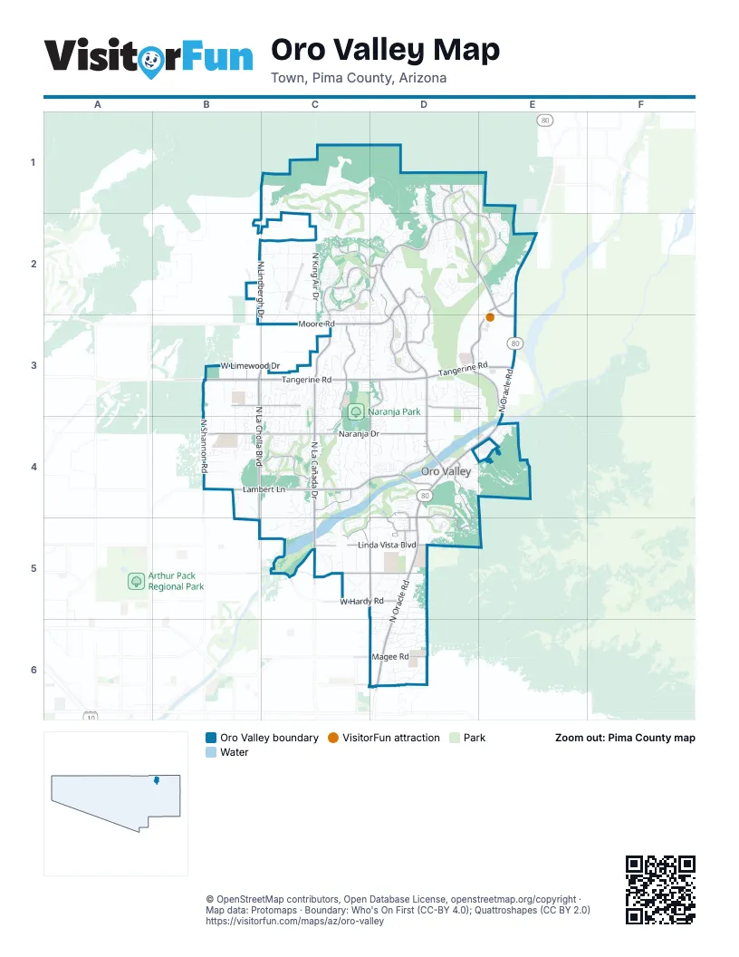
Street index of Oro Valley
Each street on the sheet and the grid squares it crosses.
- North Oracle RoadE2, E3, D4, E4, D5, D6
- North La Cañada DriveC2, C3, C4, C5
- West Tangerine RoadB3, C3, D3
- East Tangerine RoadD3, E3
- North Rancho Vistoso BoulevardD2, D3
- North La Cholla BoulevardB3, B4
- West Lambert LaneB4, C4, D4
- East Rancho Vistoso BoulevardD2, E2, E3
- North 1st AvenueD3, D4, D6
- West Moore RoadD2, C3, D3
- West Magee RoadD6
- East Pusch View LaneD4
- West Naranja DriveB4, C4, D4
- East Innovation Park DriveE2, D3, E3
- North La Reserve DriveD4, D5
- North Copper Springs TrailC3, C4
- North Water Harvest DriveD3, E3
- North Woodburne AvenueD2, D3
- North Shannon RoadB3, B4
- North Del Webb BoulevardD1, D2, E2
- West Valle del Oro RoadD4, C5, D5
- West Vistoso Highlands DriveC2, D2
- West Calle ConcordiaC5, D5
- West Canada Hills DriveB4, C4
- North Northern AvenueD5, D6
- West Pebble Creek DriveC2, D2
- North Calle Buena VistaC5, D5
- West Linda Vista BoulevardC5, D5
- East Moore LoopD2, D3
- West Glover RoadB3, C3
- West Hardy RoadC5, D5
- North Moore RoadD2
- West Congressional WayC4
- East El Conquistador WayD4, D5
- North Monterra Vista DriveD3, D4
- West Desert Fairways DriveC2, D2
- North Hidden Springs DriveD2
- East Palisades RoadD3, E3
- North Sun City BoulevardD1, D2
- East Lambert LaneD4
- West Overton RoadC5
- East Desert Sky RoadD5
- East Magee RoadD6
- East Naranja DriveD4
- East Linda Vista BoulevardD5
- East Calle ConcordiaD5
- North Desert Sky RoadD5
- East Vistoso Commerce Loop RoadE2
- North Como DriveB2, B3
- Arrowsmith DriveD3
- East Silverton AvenueD1, D2
- Egleston DriveD5
- North Summerstar BoulevardD1
- Valle del Oro RoadD5
- East Vistoso Commerence Loop RoadE2
- Catalina State Park RoadE3
- Innovation Market DriveD3
- West Chapala DriveD6
- West Tortolita Mountain CircleC1, D1, C2, D2
- East Pusch Wilderness DriveD4, E4
- North King Air DriveC2
- North Lindbergh DriveB2, C2, B3
- North Stargazer DriveC4
- North Cross RoadB4
- North Musette DriveC3, C4
- North Mandarin LaneD3, D4
- North Silver Cloud DriveD1, D2
- North Pomegranate DriveC4
- North Copper Creek DriveC3, C4
- West Granite Gorge DriveC1, D1
- West Golf View DriveC4, D4, C5
- West Limewood DriveB3, C3
- North Rancho Catalina AvenueD5, D6
- West Kitty Hawk WayC2
- Camino DiestroD4, D5
- East Catalina Shadows BoulevardD6
- North Verch WayC3, C4, C5
- North Hacienda Hermosa DriveC4, C5
- East Paseo Arroyo MayorD2, E2
- North Shore Cliff DriveD4
- North Mountain Breeze DriveC3, C4
- North Calle Loma LindaC5
- North Kachina DriveC2
- North Quiet Rain DriveD1, D2
- East Strada PataniaD3
- North Rancho Sonora DriveC4
- North Piper DriveC2
- North Lobelia WayE2
- North Alamo Canyon DriveD1, D2
- East Crown Ridge DriveD1, E1
- North Poinsettia DriveC4
- North Vista del SolB3, B4
- West Silverleaf DriveC3
- North Calle el MilagroC5
- East Suffolk DriveD6
- East Buck Ridge PlaceD4, E4
- North Camino de AnzaC5, D5
- West Greenock DriveD4
- North Scioto AvenueC3, C4
- Old Forest TrailC2
- North Hohokam Village PlaceC2
- North Shadow Mountain DriveD5
- North Lost Arrow DriveD1, E1, E2
- North Copper Mountain DriveD3
- North Tailwind DriveC2, C3
- North Big Star TrailB3, B4
- North Pioneer WayD2, D3
- North Giant Saguaro PlaceC1, C2
- North Labyrinth DriveD3
- East Cambridge DriveD6
- North Rancho Feliz DriveC5
- North Cassiopeia DriveD3
- North Piping Rock RoadC3, D3
- North Trade Winds WayE2
- North Camino CoronadoC5
- West Atua PlaceC5, D5
- North Guava DriveC4
- North Buckingham DriveD2
- North Rancho Catalina DriveD6
- North Vistoso Village DriveE2, E3
- North Rancho Verde DriveC5
- North Luzon CourtC3
- West Turtle Dove LaneB2, C2
- North Via de la VerbenitaC3, C4
- North Wild Creek DriveB4
- East Ganymede DriveD3, E3
- North Charoleau DriveE3, D4, E4
- North Camino del PlataB3
- North Village AvenueD6
- North Red Mountain DriveC3, D3
- West Plateau Ridge DriveB4
- North Cloud Ridge DriveC3, D3
- North Wide View DriveE2
- North la Tanya DriveC3, C4
- North Washbed DriveC3
- East Tangelo DriveD3, D4
- North Gemini DriveB3, B4
- West Sculptor StreetB4
- West Annandale WayC4
- North Riviera DriveD5
- North Tall Grass DriveC3
- North Stone Gate PlaceC2, D2
- North Avenida VallejoD4
- North Desert Whisper WayD4
- West Oro Valley DriveD4
- North Honey Bee TrailD2
- North Spanish Garden LaneD1, D2
- East Placita Meseta DoradaD2
- West Desert Highlands DriveC4
- West Earhart WayC2
- West Saddlehorn DriveC5
- Lipscomb WayD4, D5
- East Camino CorridaD4
- North Vistoso Park RoadD3, E3
- Community CenterC4
- North Corsair DriveC2, C3
- North Coyote Blue CourtB3, B4
- West Cessna WayB2, C2
- East Via Valle DoradoD4
- North Alder Springs DriveD4, D5
- North Barlassinia DriveC2
- North Reflection Ridge DriveC3
- North Meadow Sage DriveC3, C4
- North Skywire WayD3, D4
- North Fawnbrooke DriveD2
- West Landoran LaneC5
- North Avenida Posada de OroD4
- North Lantern WayD3
- North Flying Bird DriveD3, D4
- West Sahuaro DivideB4
- East Big View DriveE2
- North Broadstone DriveC4
- North Dragoon Springs DriveC3
- West Matterhorn StreetD4
- East Dusty View DriveD1
- North Sand Canyon PlaceB4, C4
- North Pusch Ridge View PlaceD4
- North Raleigh DriveC5
- North Granville Canyon WayD3
- North Sage Brook RoadC3
- West Travelair WayC2, C3
- North Woosnam WayC2
- West Beech WayC2
- North Eagleview DriveD2, D3
- West Desert Splendor CourtB4
- North Chalk Creek DriveD1, D2
- North Copperstone DriveD1, D2
- North Joi DriveD3
- North Choctaw DriveD1, D2
- North Calle SolanoC4, C5
- East Ponticello BlE4
- North La Quinta DriveC4
- North Ridge Shadow PlaceD4, D5
- Wrangler BoulevardB3
- West Oak Shadows DriveC5
- North Echo Valley DriveD3
- North Willow Bend DriveD2
- North Via Vista del PasadoD2, D3
- North Hydrus AvenueB4
- North Cirrus Hill DriveE2
- West Canyon Shadows LaneC5
- North Sky TrailD1, D2
- North Palmetto Dunes AvenueC3, C4
- North Rocky Highlands DriveC1
- North Meadview WayD2, D3
- West Lucero RoadC5
- North Rocky Slope PlaceC4
- West Spring Valley DriveD5
- East Kalalau DriveD3
- North Joy Faith DriveD4
- North Cliff Dweller PlaceD4, E4
- North Desert Olive DriveC2, C3
- East Mellow TrailD2, E2
- East Ruellia DriveE2
- East Oro Valley DriveD4
- North Paseo CoronaC5
- North Kylene Canyon DriveD3
- North Brightridge DriveD3
- East Desert Glen DriveD1
- Blazing Canyon DriveC1
- North Pistachio AvenueC4
- Bighorn Butte DriveD4, D5
- North Buck Ridge DriveD4, E4
- West Owl Vista PlaceB4
- North Desert Calico LoopB3, B4
- North Placita Meseta de OroD2
- North Yellowstone AvenueD5, D6
- North Maspalomas DriveC2
- West Smokethorn DriveC3
- East Linda Vista RoadD5
- East Royal Oak RoadD2
- North Summer Moon PlaceC4
- East Broken Rock DriveE4
- North Galena TrailD2
- Ca del CarneroD4
- North Sleeping Coyote DriveD3
- North Mesquite Hollywood DriveC3
- West Camino CortaroD6
- East Stone Stable DriveE4
- North Mount Bigelow RoadD3
- North Pelotazo PlaceD2, D3
- Canyon Ridge PlaceE4
- North Atalaya WayC2
- West Carmel Pointe DriveC4
- North Yellow Bird RoadC3
- North Westminster DriveC2, C3
- West Suffolk DriveD6
- West Bangalor DriveC5
- North Pusch Ridge Vistas DriveD4
- North Overlook DriveD5
- North Alyssum WayE2
- North Sanidine DriveD2
- Pioneer WayD2
- West Corax WayC2
- North la Reserve PlaceD5
- West Cool DriveD6
- East Brearley DriveD4
- North Calle GodornitzD5
- North Crescendo DriveD3
- North Sawtooth RoadD4
- East Beekeeper TrailD2
- North Twin Spur CourtC4
- North Silver Pheasant LoopC4
- West Rolling Hills StreetD5
- West Muirhead LoopC4
- New Dawn AvenueD3
- North Pilot DriveC2
- North Regulation DriveC2
- East Cliff Dweller DriveD4
- East Sonoran Desert DriveD4
- West Shimmering Desert PlaceD2
- Eagles Summit DriveC2, C3
- Hardy RoadD5
- North Granite Peak PlaceC1
- North C StreetD2
- West Bighorn Ridge RoadB3, B4
- East Vuelta Caminata del RioD4
- North Booming DriveC2
- North Biltmore DriveD2
- North Yellow Orchid DriveC2, C3
- North Calle TiogaD5, D6
- Sunny Slope DriveD5
- North Copper Queen WayD3
- North Mesquite Sunset PlaceB3
- North Quandry DriveD3
- North Bushwacker PlaceD2
- Vistoso Commerce PlaceE3
- North Silver Village PlaceD3
- East Skipping Rock WayE4
- North Highlands DriveD4
- Calle AlmendraD5
- West Meadowbrook DriveD5
- East Glenhurst DriveD5
- North Falling Rain RoadD4
- East Silver Ray DriveD3
- North Silver Cassia PlaceC2
- East Boulder PsD1
- North Canada Ridge DriveC4
- East Moonshroud DriveD3
- West Owl Head PlaceB4
Things to do on the Oro Valley map
Places on the map
- BASIS Oro Valley
- Cañada Course
- Cañada del Oro River Park
- Cañada Hills
- Canyon del Oro High School
- Conquistador Course
- Copper Creek Elementary
- El Conquistador
- El Corredor
- Entrada del Oro Plaza
- Hilton El Conquistador Hotel
- Hohokam Park
- Honey Bee Biological Corridor
- Honey Bee Canyon Park
- Immaculate Heart Academy
- Immaculate Heart High School
- Innovation Academy
- Innovation Corporate Center
- Ironwood Ridge High School
- James D. Kriegh Park
- La Cholla Airpark
- La Posada
- Mis Manos Montessori School
- Naranja Park
- Oracle Crossings
- Oro Valley Country Club Golf Course
- Oro Valley Hospital
- Oro Valley Marketplace
- Oro Valley Retail Center
- Painted Sky Elementary School
- Panorama Trails
- Pusch Ridge Christan Academy
- Pusch Ridge Golf Course
- Rancho Vistoso Center
- Rooney Ranch Shopping Center
- The Stone Canyon Club
- The Views Golf Club
- Ventana Medical Systems Inc.
- Vistoso
- Vistoso Trails Nature Preserve
© OpenStreetMap contributors, Open Database License, openstreetmap.org/copyright · Map data: Protomaps · Boundary: Who's On First (CC-BY 4.0); Quattroshapes (CC BY 2.0)















