

Arizona map
Somerton map
About 14,902 people live here (Census Bureau, 2024 estimate). The sheet's index lists 181 streets; County 15th Street, South Avenue B and South Avenue E cross the most grid squares. Also on it: Cocopah Speedway, Johnson of Somerton and Somerton City Hall.
Open the map (PDF, US Letter)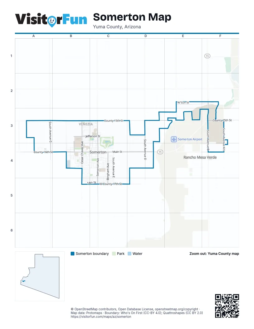
Street index of Somerton
Each street on the sheet and the grid squares it crosses.
- South Avenue CE2, E3
- South Saturn AvenueE2
- West Sun StreetE2
- South Avenue BF2, F3, F4
- South Avenue GA3, A4
- County 15th StreetB3, C3, D3, E3, F3
- North Avenida SerenidadB3, B4
- North Avienida SerenidadB3
- North Cesar Chavez AvenueB3, B4
- North Toro AvenueB3, B4
- North Van Brunt AvenueB3, B4
- West Brenda StreetB3, C3
- West Calle AmistadB3
- West Calle De PazB3
- West Calle EsperanzaB3
- West Calle Nueva VidaB3
- West Canal StreetB3, C3
- West Capitol StreetB3, C3
- West Flower StreetB3
- West Fulton StreetB3, C3
- West Jackson StreetB3, C3
- West Jefferson StreetB3, C3
- West Monroe PlaceB3, C3
- West Monroe StreetB3, C3
- West Palo Verde StreetB3
- West Sellers StreetB3, C3
- Canal AlleyC3
- Carlisle AvenueC3, C4
- East Flower StreetC3
- East Jefferson StreetC3
- East Palo Verde StreetC3
- East Washington StreetC3
- Elizabeth StreetC3
- Fulton AlleyC3
- Fulton StreetC3
- Jacobs AlleyC3
- North Andrea AvenueC3
- North Bingham AvenueC3, C4
- North Council AvenueC3
- North Daniela AvenueC3
- North Jennifer AvenueC3
- North Marshall Loop CourtC3
- North Marshall Loop RoadC3, C4
- North Musgrove AvenueC3, C4
- North Somerton AvenueC3, C4
- North State AvenueC3
- North State StreetC3, C4
- North Union AvenueC3, C4
- Somerton AlleyC3, C4
- Somerton AvenueC3
- South Avenue EC3, C4, C5
- Co 15 1/2 Street SouthD3
- South Avenue DD3, D4
- East Deere PlaceF3
- North Smith WayF3
- North Taylor WayF3
- South Avenue A½F3, F4
- West County 15½ StreetF3
- County 16th StreetA4, B4
- Cactus StreetB4
- Cano AlleyB4
- Congress AvenueB4
- Daffodil CourtB4
- East Garvin StreetB4, C4
- Eucalyptus AlleyB4, C4
- Eucalyptus StreetB4, C4
- Federal AvenueB4
- Figueroa AvenueB4
- Fresno StreetB4
- Gardenia StreetB4
- Gilda AvenueB4
- Grijalva AvenueB4
- Joshua StreetB4
- Main AlleyB4, C4
- Main Street AlleyB4, C4
- North Acacia AvenueB4
- North Parkview AvenueB4
- Orange AvenueB4
- Orchid CourtB4
- Orchid StreetB4
- Rose CourtB4
- Rose StreetB4
- South Cesar Chavez AvenueB4, B5
- South Congress AvenueB4, B5
- South Federal AvenueB4
- South Frauenfelder AvenueB4
- South Fresno AvenueB4, B5
- South Garvin CourtB4
- South Orange AvenueB4, C4, B5
- South Parkview AvenueB4
- South Sotomayor AvenueB4
- South Sunset AvenueB4
- South Zimmerman AvenueB4
- Sunflower CourtB4
- Sunflower StreetB4
- Sunset AvenueB4
- Tumbaga DriveB4
- West 12th StreetB4, C4
- West Angelica StreetB4
- West Cactus StreetB4, C4
- West Cano StreetB4, C4
- West Eucalyptus StreetB4, C4
- West Fern StreetB4, C4
- West Fresno StreetB4
- West George StreetB4, C4
- West Jacobs StreetB4, C4
- West Main StreetB4, C4
- West Maricela StreetB4
- West Orchid StreetB4, C4
- West Patricia AvenueB4
- West Ramona StreetB4
- West Renna StreetB4, C4
- West Rose StreetB4
- West Spring StreetB4, C4
- West Sunflower StreetB4, C4
- West Yucca StreetB4, C4
- Westr Daffodil StreetB4, C4
- Carlisie AlleyC4
- East 12th StreetC4, C5
- East Angelica StreetC4
- East Cactus StreetC4
- East Cano StreetC4
- East Crane StreetC4
- East Eucalyptus DriveC4
- East Eucalyptus StreetC4
- East Fern StreetC4
- East George PlaceC4
- East George StreetC4
- East Joshua StreetC4
- East Main StreetC4, D4
- East Maricela StreetC4
- East Orchid StreetC4
- East Patricia StreetC4
- East Ramona StreetC4
- East Spring StreetC4
- East Victoria LaneC4
- East Yucca StreetC4
- Fern's AlleyC4
- George AlleyC4
- Huron CourtC4
- Jacobs StreetC4
- Mendota AvenueC4
- Mendota DriveC4
- North Columbia AvenueC4
- North Xcaret CourtC4
- San Joaquin AvenueC4
- South Bingham AvenueC4, C5
- South Bingham DriveC4
- South Bingham WayC4
- South Cano StreetC4
- South Cholla AvenueC4
- South Columbia AvenueC4
- South Crane StreetC4
- South Dalton AvenueC4
- South Hill AvenueC4
- South Musgrove AvenueC4, C5
- South San Joaquin AvenueC4, C5
- South Somerton AvenueC4, C5
- South State StreetC4
- South Union AvenueC4, C5
- South Williams AvenueC4, C5
- Spring AlleyC4
- State AlleyC4
- Union AvenueC4
- West Adams StreetC4
- West Joshua StreetC4
- West Josuha StreetC4
- Co 16 1/2 Street SouthD4
- West County 16th StreetD4, F4
- South Avenue FB5
- South Federal CourtB5
- South Orange CourtB5
- West 12th PlaceB5
- West 13th PlaceB5
- West 13th StreetB5
- West 14th StreetB5, C5
- West County 17th StreetB5, C5, D5
- East 12th PlaceC5
- East 13th PlaceC5
- East 13th StreetC5
- East 14th StreetC5
Places on the map
- 24/7 Get Fit Somerton
- Ace Hardware
- AutoZone
- Avenir Financial
- Bravie T. Soto Elementary School
- Burger King
- Chevron
- Circle K
- Cocopah Rio Colorado Golf Course
- Cocopah Speedway
- Council Avenue Park
- Del Sol
- Desert Sonora Elementary School
- Desert Valley Mortuary
- Dollar General
- El Buen Taquito Extra
- Family Dollar
- Jack in the Box
- Joe Munoz Park
- Johnson of Somerton
- La Michoacana
- Little Caesars
- Marathon
- McDonald's
- Michelle's Auto Sales
- NAPA Auto Parts
- Perricone Park
- Sanguinetti Park
- Somerton City Hall
- Somerton High School
- Somerton Middle School
- Somerton Park
- Somerton Post Office
- Somerton Public Safety Building
- Somerton Valley Center
- Tierra Del Sol Elementary School
- Tierra Del Sol Elementary School Soccer Field
- Tierra Del Sol Elementary School Track
- Valle Del Encanto Learning Center
- Yuma County Somerton Library
Next to Somerton
- Orange Grove Mobile Manor
- Rancho Mesa Verde
© OpenStreetMap contributors, Open Database License, openstreetmap.org/copyright · Map data: Protomaps · Boundary: Who's On First (CC-BY 4.0); Quattroshapes (CC BY 2.0)















