

California map
Barstow map
About 24,897 people live here (Census Bureau, 2024 estimate). The sheet's index lists 300 streets; Barstow Freeway / Mojave Freeway, West Main Street and East Main Street cross the most grid squares. Things to do inside the boundary: The Outlets at Barstow.
Open the map (PDF, US Letter)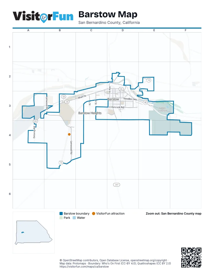
Street index of Barstow
Each street on the sheet and the grid squares it crosses.
- Barstow Freeway / Mojave FreewayD2, E2, B3, C3, D3, B4, B5
- Needles FreewayD3, E3
- Barstow–Bakersfield HighwayB3
- West Main StreetC2, D2, A3, B3, C3
- East Rimrock RoadC3, D3
- East Main StreetD2, D3, E3
- Barstow RoadD2, D3
- Montara RoadD3
- Lenwood RoadB3, B4, B5
- Armory RoadD3, E3
- South Muriel DriveD2, D3
- North 1st AvenueD2
- East Mountain View StreetD3
- Old Highway 58D2, E2
- Irwin RoadD2
- Avenue LC3
- High Point ParkwayB4
- L StreetC3
- Rimrock RoadC3
- Old Higwhay 58D2
- Riverside DriveD2, D3, E3
- Joseph L. Boll AvenueE3, F3
- H StreetC3, E3
- Jasper RoadA3, B3
- Windy PassD3
- Broadway AvenueD3
- Outlet Center DriveB5
- East Virginia WayD3
- Veterans ParkwayC3, D3
- South 1st AvenueD2, D3
- Roberta StreetD3
- Argarita AvenueD3
- South Yucca AvenueD2, D3
- South Avenue AC2, C3
- South Avenue HC3
- Crooks AvenueD2
- Soapmine RoadE2
- North Yucca AvenueD2
- West Mountain View StreetC3, D3
- Helen Runyon DriveD3
- South 7th AvenueD2, D3
- Sidewinder RoadB5
- Citrine RoadB3
- Avenue HC3
- Panamint RoadC3
- Lawrence Dale DriveD2
- Delaney RoadA4
- A StreetE3, F3
- C StreetE3
- Country Club DriveA3, A4
- East Williams StreetD2, D3
- Gerrymander RoadA3, A4
- Sweeten LaneA3, B3
- West Buena Vista StreetC3, D3
- Cape Gloucester AvenueE3
- Nancy StreetC2, C3
- Gazana StreetA4
- Kelly DriveD3
- South 2nd AvenueD2, D3
- Lillian DriveD2, D3
- East Fredricks StreetD2
- Kwajalein StreetE3
- Monterey AvenueD3
- B StreetE3
- G StreetC3, E3
- Flora StreetC3
- Higgins RoadD3
- Piute StreetD3
- Forane StreetD3
- Sunset StreetD3
- Sunrise RoadD3
- Center StreetD3
- Elizabeth StreetD3
- Quarters StreetE3
- Deseret AvenueD3
- Pine AvenueD3
- Navajo StreetD3
- Diamond AvenueD3
- Clay River RoadE3
- Calico DriveC3, D3
- Waterman RoadC2
- De Anza StreetD3
- Church StreetD3
- Linda LaneC3
- Arbor WayD3
- South Tinian StreetE3
- Viking StreetD3
- Carson StreetD3
- Santa Fe DriveC2, C3
- Hutchison StreetD2
- South Iwo Jima StreetE3
- Tarawa AvenueE3
- Sun Valley DriveB3
- Mirage DriveD3
- Juniper StreetD3
- Paloma StreetD3
- Agate RoadA3, B3
- Belinda StreetD3
- Cypress DriveD3
- Mercantile WayB4, C4
- Mount Vernon AvenueD3
- Wisteria AvenueD3
- Candlelight StreetD3
- Mayor Katy ParkwayD3
- Starlight StreetD3
- Chateau Barstow Estates LaneC3
- Tripoli DriveE3
- Opal StreetD3
- Carmen DriveD2
- O Bannon AvenueE3
- Stanford DriveD3
- East Buena Vista StreetD3
- Oasis DriveD3
- Borrego DriveD3
- Garnet AvenueC3
- State StreetD3
- Adele DriveD2, D3
- Ironwood DriveC3
- Lance DriveD3
- Barcelona CircleD3
- Avenue EC2, C3
- Arroyo DriveD3
- Webster RoadE3
- Frances DriveD2, D3
- South 6th AvenueD2, D3
- Michael StreetC3
- Ruby DriveC3, D3
- West Fredricks StreetC2, D2
- West Grace StreetC3, D3
- Coolwater LaneD3
- Coyote RoadA3, B3
- Bigger StreetD2, D3
- Capella DriveA4
- Arville AvenueD3
- Club StreetE3
- Avenue CC2, C3
- McBroom AvenueD3
- Mecca DriveD3
- East Grace StreetD3
- McIlroy StreetD2
- Clark StreetD2
- Aurora WayD3
- Salamander BoulevardA4, B4
- North 2nd AvenueD2
- P StreetC3
- Pioneer StreetD3
- Avenue BC2, C3
- Agnes DriveD3
- Moreland StreetE3
- 3rd AvenueD2
- Wake AvenueE3
- Cal AvenueD3
- East Cottage StreetD2
- Commerce ParkwayB4
- Guadalupe DriveD3
- 9th StreetE3
- Mesa DriveD2
- Pierce AvenueC2, D2
- North Iwo Jima AvenueE3
- Sierra Linda DriveD3, E3
- Canavan StreetC3, D3
- Crescent DriveD3
- Oakmont DriveD3
- Melissa AvenueD2, D3
- North Muriel DriveD2
- Amethyst AvenueC3
- Prairie DriveD3
- Avenue DC2, C3
- South Avenue GC3
- Apollo DriveA4
- May AvenueC2, C3
- High Desert RoadB4
- Zion DriveD3
- West Williams StreetD2
- Bradshaw DriveC2
- Young StreetD3
- Sunshine DriveD3
- Harvard DriveD3
- 11th StreetE3
- 13th StreetE3
- East White StreetD2
- Highland AvenueC3
- Meadow View LaneD2
- 7th StreetE3
- Astral DriveD3
- Sage DriveD2
- Yosemite CourtD3
- Lotebush LaneD3
- Silver LaneD2, D3
- North Tinian StreetE3
- Patricia StreetD3
- 5th AvenueD2
- Pallesi StreetD2
- 3rd StreetE3
- Trinity AvenueD3
- Cameo AvenueC3
- Opal AvenueD3
- Hillside DriveC2, D2
- Tara StreetD3
- Main Street Outer Highway SouthB3, C3
- Princeton DriveD3
- 14th StreetE3
- 4th StreetD2, E3
- Bighorn DriveD3
- Joshua Tree DriveD3
- Roadrunner AvenueD3
- Savanna DriveD3
- Elks LaneB3
- Stevens StreetD3
- Valley StreetE3
- Cabrillo DriveD3
- Elm StreetD3
- Fenoak DriveD3
- Fenmore DriveD3
- Victor StreetD3
- Buckthorn DriveD3
- Las Amigas DriveD3
- Caliente DriveD3
- Mescal DriveD3
- Chateau WayD3
- Cholla DriveD3
- Madrona AvenueD3
- Fisher BoulevardB4
- Kathleen DriveD3
- Silver SaddleD2
- Tecatee DriveD3
- Palo Verde DriveD3
- East Cozy AvenueD2
- Camarillo AvenueD2
- Factory MerchantsB4
- Woodham AvenueC3
- Tinian StreetE3
- Mojave DriveD2
- Jolene Farms LaneE3
- Pueblo DriveD2
- Taos DriveD2
- West White StreetD2
- Dove DriveD3
- Francis DriveD2
- Granada Hills AvenueD3
- Tanger WayB4
- Condor DriveD3
- North 6th AvenueD2
- Surrey RoadC3
- Ocotillo DriveD3
- Arville StreetD3
- Arrowhead AvenueD2
- Cottonwood DriveD3
- Spinet StreetA4
- Perth AvenueC3
- Radio RoadD2
- North 7th AvenueD2
- Palm StreetD3
- Cannon StreetE3
- Date StreetD3
- Ann StreetD3
- 6th StreetE3
- Dill RoadD3
- Falcon DriveD3
- F StreetC3
- Sandy Hill DriveD3
- Campus WayD3
- May StreetC3
- West Grandview DriveD3
- Dolomite StreetC3
- Baldwin RoadD3
- Luna DriveD3
- Manzanita DriveD3
- Vineyard StreetC3
- Roadrunner RoadA3
- Eastgate RoadD3
- Western Whip CourtD3
- Yellowstone DriveD3
- Norwich AvenueB3, C3
- Upton DriveD3
- Rushmore DriveD3
- E StreetC3
- Teton DriveD3
- Camino del SolB3
- Emerald StreetC3
- Wilshire PlaceD2, D3
- Inchon AvenueE3
- 15th StreetE3
- Bluebird StreetD3
- Otis AvenueD2
- SerranoB4
- 1st StreetE3, F3
- Mary Anne StreetD2, D3
- North Avenue HC3
- Maxine StreetD2, D3
- Berkeley DriveD3
- Barcelona CourtD3
- West Cottage StreetD2
- Pinion DriveD3
- Senita DriveD3
- Forest AvenueD3
- Nelson AvenueC3
- West Desert View DriveD3
- Yale DriveD3
- Ibis AvenueD3
Things to do on the Barstow map
Places on the map
- A-One Cycle
- Arco
- Astro Budget Motel
- AutoRepair
- AutoZone
- B Hill
- Bank of America
- Barstow Branch Library
- Barstow Christian Academy
- Barstow City Hall
- Barstow Civic Center
- Barstow Community College
- Barstow Community Hospital
- Barstow Fine Arts Academy
- Barstow Fire District Station 363
- Barstow Fire Protection District
- Barstow Fuel 76
- Barstow High School
- Barstow Junior High School
- Barstow Plant
- Barstow Plaza
- Barstow Post Office
- Barstow Road Center
- Barstow Seventh-day Adventist Church
- Barstow Skate Park
- BNSF Barstow Railyard
- California Inn
- Desert Discovery Center
- Flying J Travel Center
- Foglesong Park
- Little Sister's Truck Wash
- Love's Travel Stop
- Marine Corps Logistics Base Barstow
- Outlets at Barstow
- Pilot Travel Center
- Robert A. Sessions Memorial Sports Park
- Saint Joseph
- Tees & Trees Golf Course
Next to Barstow
- Barstow Heights
© OpenStreetMap contributors, Open Database License, openstreetmap.org/copyright · Map data: Protomaps · Boundary: Who's On First (CC-BY 4.0); Quattroshapes (CC BY 2.0)















