

California map
Clearlake map
About 16,636 people live here (Census Bureau, 2024 estimate). The sheet's index lists 300 streets; Lakeshore Drive, Old Highway 53 and Sulphur Bank Road cross the most grid squares. Also on it: Borax Lake, Adventist Health Clear Lake and Austin Park.
Open the map (PDF, US Letter)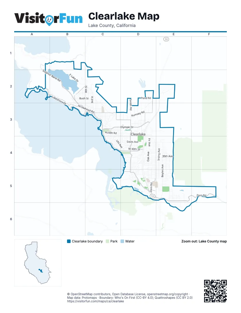
Street index of Clearlake
Each street on the sheet and the grid squares it crosses.
- Lakeshore DriveA2, B2, B3, C3, C4, D4
- Old Highway 53D2, E2, D3, D4, D5
- Dam RoadD5, E5, F5
- Sulphur Bank RoadA1, B1, A2, B2
- Olympic DriveC3, D3
- Burns Valley RoadC3, D3
- Country Club DriveB2, C2, B3, C3
- San Joaquin AvenueA2, B2, B3
- Arrowhead RoadB3, C3
- Park StreetC3, D5
- Lake StreetE5
- Boyles AvenueE4, E5
- Davis AvenueD4, E4
- Oak AvenueD3, D4, D5
- Irving AvenueE4, E5
- Phillips AvenueD4, D5
- Eureka AvenueD3, D4, D5
- Eastlake DriveC2, C3
- 18th AvenueD5, E5
- Konocti AvenueE4, E5
- Pine AvenueD3, D4, D5
- 31st AvenueD4, E4
- Uhl AvenueC3, C4, D4
- East Lake DriveB2, C2, C3
- West 40th StreetC4, D4
- 32nd AvenueD4, E4
- 33rd AvenueD4, E4
- 34th AvenueD4, E4
- 30th AvenueD4, E4
- 29th AvenueD4, E4
- 28th AvenueD4, E4
- Alvita AvenueC3, D3, C4
- 22nd AvenueD5, E5
- 21st AvenueD5, E5
- 40th AvenueD4, E4
- 20th AvenueD5, E5
- Wilkinson AvenueE4, E5
- Cedar AvenueD3, D4
- 37th AvenueD4, E4
- Rumsey RoadD3
- 19th AvenueD5, E5
- 26th AvenueD4, E4
- 38th AvenueD4, E4
- 35th AvenueD4, E4
- Bush StreetB2, C2
- Oakmont DriveA2
- 8th StreetC2, C3
- Pearl AvenueC3, C4, D4
- Spruce AvenueD4, D5
- Hillcrest AvenueC4, D4
- Palmer AvenueC4, D4
- 10th StreetB2, B3
- 7th StreetC2, C3
- 39th AvenueD4, E4
- Highlands Harbor RoadD5
- Woodland DriveC3
- 6th StreetC2, C3
- Crawford AvenueD4, D5
- Ogulin Canyon RoadE2
- Robin LaneD2, D3
- Smith RoadD2, D3
- 24th AvenueD5, E5
- 5th StreetC2, C3
- 3rd StreetC2, C3, E5
- 23rd AvenueD5, E5
- 4th StreetC2, C3
- 27th AvenueD4, E4
- Meadowbrook DriveD5
- Pamela LaneD2, D3
- 9th StreetB2, B3
- Polk AvenueD3, E3
- 11th StreetB2, B3
- Mullen AvenueC3, C4
- Oak StreetB2, C2, D4, D5
- Cache Creek WayD5
- Austin RoadC3
- Robinson AvenueC3, C4
- 12th StreetB2, B3
- Fir AvenueD3, D4
- 13th StreetB2, B3
- 43rd AvenueD4, E4
- Hillside RoadB2, C2
- Walnut AvenueC3, D3
- Carter LaneB2, B3
- Toyon StreetC2, C3
- 2nd StreetC2, C3
- Turner AvenueD3
- Manzanita AvenueD4
- Manakee AvenueC3
- Buckeye StreetC3, C4
- Sonoma WayC3
- Terrace DriveA2, B2
- Hemlock AvenueD3, D4
- Pond RoadD2
- Parker AvenueE5
- Cass AvenueD4
- Golf AvenueD4
- Hale AvenueD4, D5
- Austin AvenueC3, D3
- 41st AvenueD4, E4
- Ridge RoadC4
- 14th StreetB2, B3
- Peony StreetC2, C3
- Emory AvenueC4, D4
- Anderson Marsh State Historic ParkC5, D5
- Garner LaneD3
- 25th AvenueD4, D5, E5
- Oleander StreetC2, C3
- 42nd AvenueD4, E4
- Fair Oak RoadB3, C3
- Brannon AvenueD4, E4
- 3rd AvenueE5
- Denman RoadD2, D3
- 4th AvenueE5
- East LakeC2
- 8th AvenueE5
- Lower Lakeshore DriveC3
- Lakeview AvenueC3, D4
- Reid LaneD2, C3, D3
- Victor StreetD5
- Sonoma StreetC3
- Santa Clara AvenueB3, C3
- 5th AvenueE5
- Valley AvenueC4, D4
- Cypress AvenueD4
- Oakland AvenueC3, C4
- Manchester AvenueD3, D4
- Lakeview WayD5
- 15th StreetB2
- Oak DriveA2
- South Center DriveD5
- Howard AvenueC3, C4
- Ball Park AvenueD4
- Lakeside DriveD5
- Schulz AvenueD3, D4
- Frye AvenueD4
- 14th AvenueE5
- Fillmore StreetD3
- 10th AvenueE5
- Ciwa StreetC3
- Highland AvenueD4, D5
- James StreetD4, D5
- 13th AvenueE5
- Vista StreetC3
- Acacia StreetC3
- Wilkinson RoadE4
- Halika StreetC3
- Huron AvenueD4, D5
- Mountain View StreetC3
- 44th AvenueD4, E4
- Taawina StreetC3
- Pomo RoadC3
- Sampson DriveB3
- Cottage AvenueD4, D5
- Laddel AvenueC3, C4
- Snook AvenueD4
- Sunset AvenueD4
- Crandall AvenueD4
- Austin DriveD3
- Mesa DriveA2
- Wilder AvenueD4
- Bowers AvenueD3
- Harbor LaneD5
- Betz DriveE5
- Jefferson StreetD3
- Dam Road SouthE5, E6
- Huntington AvenueC3
- Stonybrook DriveD5
- 17th AvenueE5
- Green AvenueD3
- 12th AvenueE5
- Highlands WayD4
- 16th StreetB2
- 9th AvenueE5
- Jackson StreetD3
- Mateo AvenueE5
- Konocti View RoadD4
- Saroni ParkwayD4
- Hill AvenueD3, D4
- San Joaquin ExtendedA2
- Grey AvenueD3
- Jones AvenueD4
- Ridgeview DriveD5
- Colusa StreetC3
- Sonoma AvenueC3
- Morgan AvenueC3
- Ghiorzi LaneD3
- 45th AvenueD4, E4
- Brown StreetD3
- Kabal StreetC3
- Marin StreetB3
- Division StreetC3
- Villa WayC3
- Maple StreetC3
- Blue Gum StreetC3
- Madrone StreetC3
- Trouble LaneE5, E6
- Cypress StreetC3
- Redwood StreetD3
- Sycamore StreetD3
- Laguna AvenueD4
- Emerson StreetD3
- Utah StreetD4
- Vista Robles WayD3, D4
- Audra RoadE4
- Hayes AvenueD3
- Yarrington CourtD4
- Cottonwood StreetC3
- Scenic RoadC3
- Lincoln AvenueD3
- Mediros LaneD2, D3
- Youngs LaneC3
- Lelabelle BoulevardD4
- Woodside DriveD5
- Argonne AvenueD3
- East DriveE5
- Koloko StreetC3
- Memory LaneC3
- Cache Creek LaneE6
- Harrison StreetD3
- Konocti RoadC3
- Denton LaneD3
- Moss AvenueD4
- Amber AvenueD3
- Laskey AvenueD4
- Cache StreetE5
- Fellers LaneC2, C3
- Duncan AvenueD3
- Arnold AvenueD4
- Lotawana RoadD4
- Baylis AvenueC3, C4
- Laguna Vista WayD4
- Locust StreetC3
- Moose TraceC3
- Wayland WayD4
- Birch AvenueD4
- El Camino RealD3, D4
- Lupcyoma StreetC3
- Lansing AvenueD4
- Monterey DriveA2
- 16th AvenueE5
- Sharpe LaneD3
- Clement DriveD4
- Madison DriveD3
- Carrol AvenueD4
- Borie AvenueD4
- Emile AvenueE4
- Pine StreetC3
- Olive StreetC3
- Lilac AvenueD3
- Calaveras DriveA2
- Mint StreetC3
- Old Dam RoadE5
- Beach AvenueD4
- Mariposa DriveA2
- Spruce StreetD4
- McKinley DriveD3
- Bay StreetD5
- Risher AvenueD3
- Boxwood StreetC3
- Rose LaneD3
- Villa AvenueD4
- Brown AvenueD4
- Washington StreetD3
- Fresno StreetC3
- Modoc StreetC3
- Ogulin CourtE2
- Stanyon StreetD4
- Lane AvenueD4
- Napa StreetB3
- Bartram CircleD3
- Mason StreetD4
- Mendocino StreetB3
- Blue Jay AvenueD4
- Pacific AvenueD4
- Mohican PlaceD4, D5
- Redbud LaneC3
- Myrtle LaneD3
- Polk DriveD3
- Hudson AvenueD4
- Putnum LaneD4
- Garfield AvenueD3
- Ukiah StreetC3
- Rosewood LaneC3
- Andy Rays RoadE5, E6
- Brunetto LaneD2
- Country Road 213BE4
- Covelo StreetC3
- Lily Cove DriveA2
- Lenore AvenueD4
- Parkview DriveB2
- Pearl StreetC3
- Ridge StreetB2
- Weiper AvenueC3
- Chateau AvenueD4
- Crest StreetB2
- Airport RoadD5
- Braendlin AvenueD4
- Mattioda CourtD3
- Dexter LaneD3, D4
Places on the map
- Adventist Health Clear Lake
- Adventist Health Clear Lake Medical Office - Clearlake, Live Well Program
- Americas Best Value Inn & Suites Clearlake Wine Country
- Austin Park
- AutoZone
- Autumn Village
- B and G Tires
- Best Western El Grande Inn
- Big 5 Sporting Goods
- Big O Tires
- Borax Lake
- Burns Valley Elementary School
- Burns Valley Mall
- Carl's Jr.
- Church of the Nazarene
- Clear Lake Cottages & Marina
- Clearlake City Hall
- Clearlake Dental
- Clearlake Park Post Office
- Clearlake Stadium Cinema
- Community First Credit Union
- Delicias Alvarez
- Foods Etc IGA
- Grocery Outlet
- Highlands Food Park
- Kingdom Hall of Jehovah's Witnesses
- Konocti Education Center
- Kour Thai
- Lake County Tribal Health Southshore Clinic
- Lake Pharmacy
- Mendo Mill
- O'Reilly Auto Parts
- Olympic Villa Apartments
- Orchard Park Assisted Living & Memory Care
- Patriot
- Pomo Elementary School
- Queen of Peace Catholic Church
- Redbud Branch Lake County Library
- Redbud Park
- Schoolteacher Hill
© OpenStreetMap contributors, Open Database License, openstreetmap.org/copyright · Map data: Protomaps · Boundary: Who's On First (CC-BY 4.0); Quattroshapes (CC BY 2.0)















