

California map
Indio map
About 94,275 people live here (Census Bureau, 2024 estimate). The sheet's index lists 300 streets; Sonny Bono Memorial Freeway, Jefferson Street and Madison Street cross the most grid squares. Also on it: Empire Polo Club, Heritage Palms Country Club and I-10 Auto Mall.
Open the map (PDF, US Letter)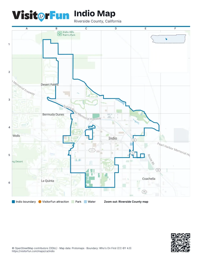
Street index of Indio
Each street on the sheet and the grid squares it crosses.
- Sonny Bono Memorial FreewayA2, B2, B3, C3, D3, E3, E4
- Route 86E4
- Indio BoulevardC3, D3, D4, E4, E5
- Jefferson StreetB1, B2, B3, C3, B4, B5, B6
- Avenue 48B5, C5, D5, E5
- Golf Center ParkwayE3, E4
- 47th AvenueB4, C4
- CA- 111D4
- 46th AvenueD4, E4
- Dillon RoadE5
- Monroe StreetD2, D3, D4, D5, D6
- Avenue 42B3, C3, D3, E3
- Jackson StreetD2, D3, D4, D5, D6
- Madison StreetC1, C2, C3, C4, C5, C6
- Fred Waring DriveB3, C3, D3, D4
- Avenue 50B6, C6, D6
- Doctor Carreon BoulevardC4, D4, E4, C5
- Varner RoadB2, C2, C3
- Avenue 52C6, D6
- Country Club DriveB2, B3, C3, D5
- Dune Palms RoadB1, B4
- Van Buren StreetE4, E5
- Las Palmas RoadD4
- Miles AvenueB4, C4, D4
- Avenue 40B2, C2, D2
- Avenue 44D3, E3, F4
- Oasis StreetD3, D4, D5
- Clinton StreetC3, C4, C6
- Avenue 49B5, C5, D5
- Shields RoadC4, C5
- Avenue 43C3, E3
- Calhoun StreetE3, E4, E5
- Avenue 46C4, D4
- Avenue 45D4, E4
- Requa AvenueD4, E4
- Avenue 51C6, D6
- Avenue 41D2
- Adams StreetB1, B2
- Burr StreetC3
- Gore StreetD2, D3
- Indio Springs DriveE4
- Hoover AvenueD3, D4
- Indio Springs ParkwayE4
- Westward Ho DriveC4
- Hoover StreetD3, D4
- Fifties WayB2
- Sun City BoulevardB2, C2
- Arabia StreetD3, D4, D5
- Avenue 38B1, C1
- Terra Lago ParkwayE3, F3
- North Sun City BoulevardC2
- Palm DriveC5
- Polo Estates BoulevardD6
- Desert Grove DriveD5
- Showcase ParkwayD3
- King StreetD3, D4
- Towne StreetD3, D4
- Talavera BoulevardB1, C1
- Oleander AvenueC3, D3
- Deglet Noor StreetD3, D4
- Odlum DriveD5
- Avenida SombraC2, D2
- Hjorth StreetC5, C6
- Camino Santa EliseB2, C2, C3
- Kenner AvenueD3
- Cabazon AvenueE4, E5
- Lago VistaE3
- South Heritage Palms DriveC3, C4
- Bliss AvenueD4
- Avenue 39B2, C2
- Rubidoux StreetD4
- Barrymore StreetD5
- Date AvenueD4, E4
- Camino Los MilagrosC2, D2
- Dillon AvenueD4, E4
- Smurr StreetD3, D4
- Camino San LucasC2, C3
- Palmwood DriveC4
- Crest AvenueD3
- Royal Troon DriveC3, C4
- Market StreetD3, D4
- Mountain View AvenueD3
- Adria DriveF3
- Sierra AvenueD4
- Sun Gold StreetD4
- Broadmoor DriveD2, E2, E3
- Avenida EstucoC2, D2
- Heifitz DriveD5
- Citrus AvenueE4
- Jasper Park AvenueC4
- Camino MonteviedoC2, D2
- Tourmaline AvenueD4, E4
- Emerald AvenueD4, E4
- Camino San MateoC2
- Padova DriveD2
- Treviso DriveF3
- Ullswater DriveC1
- Wayne StreetD5
- Camino San GregorioC2
- Plaza AvenueD4
- Cochran DriveD5
- Redford WayD5
- Lago Brezza DriveE3
- North Heritage Palms DriveC3
- Commerce StreetE4
- Pebble Beach DriveB4, C4
- Sirocco AvenueC4, D4
- Valencia AvenueD4
- Via Terra LagoE3, F3
- Avenida Santa CarmenC2
- Patrick DriveC1, C2
- John Nobles AvenueD4
- Rancho Los Coyotes DriveB1, B2
- Rancho Los Cerritos DriveB1, B2
- Youngs LaneC4, C5
- Palo Verde StreetE3, E4
- Greenbrier DriveD3, E3
- Hopi AvenueE3
- Palm StreetD4
- Beringer DriveE3, E4
- Eisenhower DriveD5
- Albion DriveD5, E5
- Primrose LaneC1, C2
- Royal Lytham DriveC4
- Shadow Ranch DriveE3
- Caribe AvenueD5, E5
- Melkesian BoulevardE3, E4
- Shadow Hills WayD2, E2
- Camino VallecitaC2, D2
- Solano AvenueD5
- Jasmine LaneC4
- Sardinia RoadD2
- East McCarroll DriveD6
- Royal Dornoch DriveC3, C4
- Canzone DriveE3
- Orange Grove AvenueD3
- Camino Santa JulianaC2, C3
- Royal Birkdale DriveC4
- Ruby AvenueD4, E4
- Calico AvenueD5
- Big Canyon StreetB4
- Corte ValdemoroC2, D2
- Lincoln DriveD5
- Lemon Grove AvenueD3
- Antigua DriveD5, E5
- Molvena DriveF3
- Ocotillo AvenueD3
- Fargo StreetD4
- Green Hills DriveC4
- Biery StreetD5
- Adobe RoadD3
- Avenida Linda VistaC2
- Coco Palm DriveC4
- Long Cove DriveD2, E2
- Vista del OroE3
- Garden AvenueD4
- Camino el TriunfoC2, D2
- Palm Meadows DriveC4
- Coral Mountain DriveD6
- Harrison StreetF3
- Camino Mira MonteE3
- Piazza del ParadisoD2
- Willow LaneC4
- Rock Rose DriveC5
- Tahquitz AvenueD4
- Grant DriveD5
- Avenida MonturaC2
- San Chapelle CourtE3, E4
- Reclinata WayC3
- Calle PampasC2, C3
- Disney DriveD5
- Calle PuebloD2, D3
- Civic Center DriveD4
- Calle DiamanteC5
- Margarita StreetD5
- Aladdin StreetD4
- Calle Santa SofiaC2, C3
- Muirfield DriveC4
- Saint Andrews DriveC3
- Ermo WayE3
- Avenida Los PadresC3
- Caprice DriveC1
- Constitution DriveC5
- Morris StreetE2, E3
- Carmel Valley AvenueB4
- Avenida ColoniasC2
- San Jacinto AvenueD4
- Sola StreetD3
- Meadow Lake DriveC4
- Balboa PlaceC5
- Celebration DriveD6
- Cabrillo PlaceC5
- Longmeadow StreetD6
- Trader PlaceC3, D3
- Generations DriveD3
- Camino de Las ColinasE3
- Camino AguaceroC2
- Bear Creek StreetD2, D3
- Industrial PlaceD3
- Doolittle DriveD5
- Santa Rosa AvenueD4
- Camino Las HoyesC2
- Sabrina CourtB2
- Magellan PlaceC5
- Camino LampazosC2
- Via EstacioC5
- Cortez PlaceC5
- Sunny Dunes DriveC4
- Golden Eagle DriveD6
- Tigris AvenueC5
- North Two Palms WayD6
- Olympus DriveE3
- El Paseo AvenueD3
- Smoke Tree StreetD3
- Westwick DriveB1, C1
- Pacino StreetD5
- Lewis RoadD5
- Worldmark WayE3
- Sentiero BoulevardE3
- Clubhouse DriveD6
- Montpelier DriveC5
- Saddle Ranch RoadE3
- Avenida San IgnacioC2
- Sherman StreetD5
- Gable DriveD5
- Camden DriveB1
- Escalante StreetC5
- Aetna Springs RoadE2, E3
- Ponderosa DriveD6
- Colorado StreetC5
- Maramar DriveB1, C1
- Dartmouth AvenueC4
- Camino MontecitoC2
- Jordan StreetC5
- Swinton DriveE3
- Puccini DriveD2
- Cheyenne RoadD4, D5
- Columbia AvenueC4
- Gila River StreetC5
- Calle de PalmaE3
- Caravan StreetD5, E5
- Espana BoulevardB2
- Peach StreetE4
- Royal Saint George DriveC3
- Camino PiscinaC2
- Camino SevillaC2
- Granada DriveC4, D4
- Cottonwood LaneC4
- Serrano LaneD3, D4
- Avenida ViescaC2, D2
- Half Moon Bay DriveB4
- Medjoul DriveC3, D3
- Grace StreetD4
- Spectrum StreetD3
- Duquesne StreetC4
- Orchard DriveC5
- Denton DriveC1
- Corte ComprasC2
- Picasso CourtB2
- Avenida NeblinaC2
- Crosby DriveD5
- Round Valley DriveD6
- Calle del SolE3, C5
- Corte MonteleonC2, D2
- Caspian StreetD3
- Stazzano PlaceF3
- Banff Springs StreetB4
- Shadow AvenueC4, D4
- Spirit Mountain DriveD6
- Bogart DriveD5
- East Circle DriveD3, E3
- Desert Flower DriveC4
- Paseo de TiempoC5
- Hoylake DriveC3
- Tramonto WayE3
- Alamo StreetD5, E5
- Comanche StreetE3
- Garland RoadD5
- Victoria StreetD5
- Marilyn StreetD4, E4
- Melbourne StreetB1
- Serenity AvenueC5
- Myoma Ranch RoadB2
- Wilson AvenueD4
- Royal Aberdeen DriveC3
- Knightswood RoadC4
- Spyglass Hills StreetC4
- Douglas StreetD5
- Whitehaven DriveC1
- Shadow Palm AvenueD4
- Park StreetD4
- Bradford DriveB1
- De Oro AvenueC4, D4
- Golden Gate DriveB5, C5
- Lido AvenueC4, D4
- Lundberg LaneD5, D6
- Main StreetD3
- Sagebrush StreetD3
- Kenya DriveC3
- De Coronado DriveC5, D5
Places on the map
- 24 Hour Fitness
- A T Designs
- Citrus Plaza
- Davis Sports Complex
- Desert Shores
- Empire Polo Club
- Field Three
- Field Two
- flea market
- General Patton Field
- Heritage Palms Country Club
- I-10 Auto Mall
- Indian Palms Golf Course
- Indian Springs Golf Club
- Indio Branch Riverside County Law Library
- Indio Grand Marketplace
- Indio High School
- Indio Juvenile Hall
- Indio Middle School
- Indio Municipal Golf Course
- Indio Towne Center
- John Glenn Middle School
- Max T McCandless Memorial Branch Riverside Public Library
- Miles Avenue Park
- Motorcoach Country Club
- Outdoor Resort Indio
- Rancho Casa Blanca Resort
- Riverside County Fairgrounds
- Riverside County Psychiatric Health Facility
- Shadow Hills Golf Club - North Course
- Shadow Hills Golf Club - South Course
- Shadow Hills High School
- Shields Date Garden
- Showcase at Indio
- South Jackson Park
- The Golf Club at Terra Lago
- The Plantation Golf Club
- The Walk
- Woodrow Wilson Middle School
Next to Indio
- Bermuda Dunes
- Coachella map
- Desert Palms
- La Quinta map
© OpenStreetMap contributors, Open Database License, openstreetmap.org/copyright · Map data: Protomaps · Boundary: Who's On First (CC-BY 4.0); Quattroshapes (CC BY 2.0)















