

California map
Moreno Valley map
About 213,919 people live here (Census Bureau, 2024 estimate). The sheet's index lists 71 streets; Perris Boulevard, Alessandro Boulevard and Heacock Street cross the most grid squares. Also on it: Alessandro Middle School, Amazon ONT6 and Amazon ONT8.
Open the map (PDF, US Letter)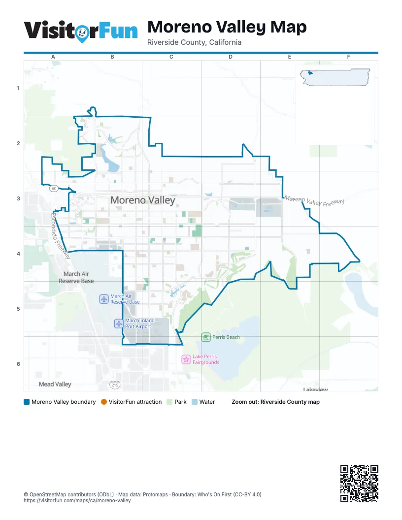
Street index of Moreno Valley
Each street on the sheet and the grid squares it crosses.
- Hidden Springs DriveB1, B2
- Clark StreetA2, A3
- Morton RoadA2
- Wordsworth RoadA2, A3
- Heacock StreetB2, B3, B4, B5, B6
- Indian AvenueB2, B3, B5
- Manzanita AvenueB2, C2
- Old Lake DriveB2
- Perris BoulevardB2, C2, C3, C4, C5, C6
- Pigeon Pass RoadB2, B3
- Presidio Hills DriveB2
- Reche Vista DriveB2
- Sunnymead Ranch ParkwayB2
- Kitching StreetC2, C3, C4, C5
- Locust AvenueD2
- Moreno Beach DriveD2, D3, D4
- Redlands BoulevardD2, D3, D4
- Arbor Park LaneA3
- Box Springs RoadA3
- Campus ParkwayA3
- Canyon Springs ParkwayA3
- Cottonwood AvenueA3, B3, C3, D3, D4
- Day StreetA3, A4
- Dracaea AvenueA3, B3, C3, D3
- Elsworth StreetA3, A4
- Escondido FreewayA3
- Eucalyptus AvenueA3, B3, C3, D3, E3
- Gateway DriveA3
- Ironwood AvenueA3, B3, C3, D3, E3
- Memorial WayA3
- Moreno Valley FreewayA3, B3, C3, D3, E3
- Old 215 Frontage RoadA3, A4
- Town CircleA3, B3
- Towngate AvenueA3, B3
- Valley Springs ParkwayA3
- Centerpoint DriveB3
- Cockatiel DriveB3
- Frederick StreetB3, B4
- Graham StreetB3, B4
- Gregory LaneB3
- Hemlock AvenueB3, C3
- Heritage WayB3
- Indian StreetB3, B4, B5
- McCully CourtB3
- Sunnymead BoulevardB3, C3
- Swan StreetB3
- Elder AvenueC3, D3
- Fir AvenueC3
- Lasselle StreetC3, C4, C5, C6
- Morrison StreetC3, C4
- Auto Mall ParkwayD3
- Nason StreetD3, C4, D4
- Oliver StreetD3, D4
- Gilman Springs RoadE3, F4
- Theodore StreetE3
- World Logistics Center ParkwayE3, E4
- Alessandro BoulevardA4, B4, C4, D4, E4, F4
- Bay AvenueA4, B4, D4
- Cactus AvenueA4, B4, C4, D4
- Brodiaea AvenueB4, C4
- Delphinium AvenueB4, C4
- Gentian AvenueB4, C4
- John F Kennedy DriveB4, C4, D4
- Riverside DriveB4
- Camino FloresC4, C5
- Iris AvenueC4, D4, B5, C5
- Via Del LagoD4, D5
- Davis RoadE4, E5
- Krameria AvenueB5, C5
- Via del LagoD5
- Evans RoadC6
Places on the map
- Alessandro Middle School
- Amazon ONT6
- Amazon ONT8
- Badger Springs Middle School
- Box Springs School
- Broadstone Rancho Belago Apartments
- Butterfield Elementary School
- Calvary Chapel
- Canyon Springs High School
- College Park
- Cottonwood Golf Center
- Country Squire Mobile Estates
- El Potrero Park
- Gateway Park
- Hidden Springs Community Park
- Highland Fairview Logistics
- Hyde Park
- Integrated Care Communities
- Kaiser Permanente Moreno Valley Medical Center
- Landmark Middle School
- Lasselle Elementary School
- Lasselle Place
- Lasselle Sports Park
- Lowe's
- Majestic Hills Estates
- Mandalay
- March Middle School
- March Mountain High School
- Mesa Verde Gated Community
- Moreno Beach Plaza
- Moreno Beach Plaza II
- Moreno Compressor Station
- Moreno Valley
- Moreno Valley Civic Center
- Moreno Valley Community Park
- Moreno Valley Equestrian Center
- Moreno Valley High School
- Moreno Valley Mall
- Moreno Valley Plaza
Next to Moreno Valley
- Lakeview
- March Air Reserve Base
- Mead Valley
© OpenStreetMap contributors (ODbL) · Map data: Protomaps · Boundary: Who's On First (CC-BY 4.0)