

California map
Napa map
About 76,921 people live here (Census Bureau, 2024 estimate). The sheet's index lists 300 streets; Saint Helena Highway, Solano Avenue and Soscol Avenue cross the most grid squares. Also on it: Alston Park, Alta Heights Elementary School and Bel Aire Park Magnet School.
Open the map (PDF, US Letter)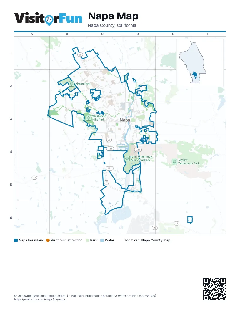
Street index of Napa
Each street on the sheet and the grid squares it crosses.
- Saint Helena HighwayB1, C1, C2, C3, C4, C5, D5
- Soscol AvenueD2, D3, D4
- West Imola AvenueC4, D4
- Silverado TrailD2, D3
- Napa-Vallejo HighwayD4, D5
- Carneros HighwayC5
- Jefferson StreetC1, C2, C3
- Solano AvenueB1, C1, C2, C3
- California BoulevardC2, C3
- 1st StreetC3, D3
- Redwood RoadB2, C2
- Trancas StreetC2, D2
- Lincoln AvenueD2, C3, D3
- Browns Valley RoadB2, B3, C3
- Napa Valley Corporate DriveD5
- Old Sonoma RoadC3
- 2nd StreetC3, D3
- West Lincoln AvenueC3
- Napa Valley Corporate WayD5
- Vista Point DriveD5
- Linda Vista AvenueB2, C2, C3
- Laurel StreetC3, D3
- Main StreetC2, C3, D3
- Trower AvenueC1, B2, C2
- Montecito BoulevardD2, D3
- 3rd StreetC3, D3
- Foster RoadC3, C4
- South Freeway DriveC3, C4
- West Pueblo AvenueB2, C2
- Pueblo AvenueC2, D2
- East AvenueD2, D3
- Coombs StreetD3
- Streblow DriveD4
- Shurtleff AvenueD3, D4
- South Jefferson StreetC3, C4
- Buhman AvenueB3
- Coombsville RoadD3
- Salvador AvenueB1, C1
- Big Ranch RoadC1, C2, D2
- Sierra AvenueC2
- James Diemer DriveD4
- Imola AvenueD4
- Lone Oak AvenueC3
- Gasser LaneD3, D4
- Shetler AvenueD4
- Kaiser RoadD5
- Riversound WayD5
- Terrace DriveD3
- Golden Gate DriveC4
- South Coombs StreetD3, D4
- East 1st StreetD3
- Lakeview DriveD3
- Hayes StreetC3
- Magnolia DriveD4
- Old Soscol WayD2
- Yount StreetC3, D3
- Anselmo CourtD5
- South Napa Valley Market PlaceD4
- Brown StreetC2, C3, D3
- Stanly LaneC5
- Pine StreetC3, D3
- Yajome StreetC2, C3, D3
- Twin Oaks DriveB3
- Partrick RoadB2, B3
- Oak StreetC3, D3
- Elm StreetC3, D3
- Wine Country AvenueB1, C1, B2
- Scenic DriveB3
- Seminary StreetC3
- Randolph StreetD3
- Franklin StreetC3, D3
- El Centro AvenueC1
- Central AvenueC2, D2
- Hacienda DriveB1
- Kilburn AvenueC3
- Villa LaneC2
- Kansas AvenueD4
- West Park AvenueC2, C3
- Adrian StreetC2, C3, D3
- Homewood AvenueC3
- Pear Tree LaneC2, D2
- G StreetC3
- Byway EastB1, C1, C2
- Circle DriveD3
- Roy Patrick DriveD4
- Westview DriveB2, B3
- Newell CircleB1
- Broadmoor DriveB2, B3
- Marin StreetC2, C3
- Seville DriveD3, D4
- North Newport DriveC4, D4
- Cayetano DriveD3
- Oxford StreetC2
- Stonehouse DriveD2
- Riverside DriveD3
- Reed CircleC1
- Jackson StreetC3, D3
- Baywood LaneC2
- Beckworth DriveC2
- Young AvenueB2, C2
- Hemlock StreetC4, D4
- Falcon Crest CircleB1
- Monroe StreetC3
- Spruce StreetC3, D3
- Park AvenueC2, C3
- Willis DriveC2
- River Park BoulevardC4, D4
- D StreetC3
- Diablo StreetC2
- Maher StreetB1, B2, C2
- Collier BoulevardC3
- Summerfield DriveC1
- Stonebridge DriveB3
- La Homa DriveC2, D2
- Seymour StreetC3
- Vine Hill DriveB2
- Saratoga DriveD3
- Home Hill RoadC5, C6
- Beard RoadC2
- Fountain Grove CircleC1, C2
- Thompson AvenueB3
- H StreetC3
- Spencer StreetC3
- Golden Gate CircleC4
- York StreetC3
- Georgia StreetC3
- Pinewood DriveB2, B3
- Leaning Oak DriveB3
- Stanly CrossroadC5
- Lassen StreetC2
- Menlo AvenueC2
- South Terrace DriveD3, D4
- Walnut StreetC3
- E StreetC3
- F StreetC3
- Tallac StreetC2
- Juarez StreetD3
- Clay StreetC3, D3
- Tall Grass DriveB3
- Grandview DriveC4
- Casswall StreetC3, C4
- Valley Club CircleC2
- Rubicon StreetC2
- Morningside DriveB3
- Village ParkwayC4
- Moffitt DriveC1
- El Capitan WayC2
- Highland DriveD3
- Patton AvenueE3, D4, E4
- Dover StreetC2
- Baxter AvenueC2
- Bordeaux WayD5
- Euclid AvenueC2, C3
- Waverly StreetC3
- Wise DriveC2
- Foothill BoulevardC3
- Meadowlark DriveC1
- Roosevelt StreetC3
- Ashlar DriveD2
- Idlewild AvenueC2
- Sonoma StreetC2, C3
- East Spring StreetD3
- Skylark WayB3
- Peatman DriveD3
- Stonybrook DriveB3
- Chelsea AvenueC3
- Ash StreetC3, D3
- Summerbrooke CircleC2
- West F StreetC3
- Braydon PlaceD3
- Montgomery StreetC3
- Meadowbrook DriveB3
- River Glen DriveD2
- Tanglewood WayC1
- 4th StreetD3
- Towpath DriveD2
- Brittany CircleB2
- Canterbury DriveC4
- West Clay StreetC3
- Cedar DriveD3
- Coronado AvenueD4
- Wilkins AvenueD4
- Monte Vista DriveD3
- Luke DriveB1
- Pinot DriveB2
- King AvenueD2, D3
- Summit AvenueD3
- Yellowstone StreetC2
- Garfield LaneC2
- Glenwood DriveC3
- Klamath WayC2
- Meek AvenueD2, D3
- Minahen StreetC4
- Vallejo StreetC3, D3
- Pearl StreetD3
- South Hartson StreetC3, C4
- Crestview WayB3
- Tamarisk DriveD3
- Tokay DriveB2
- Dewitt AvenueC3
- Wilson StreetC3
- Old Vine WayC2
- Rigdon StreetB2
- Borrette LaneB2
- Austin WayB3
- Orchard AvenueB1
- Salvador Avenue WestB1
- Delpha DriveC2
- Edgewater DriveD2
- McKinstry StreetD3
- Wyatt AvenueD3
- Hilltop DriveC3
- Lernhart StreetC4
- Stadium AvenueC2
- McKenzie DriveD3
- Stockton StreetC3
- Webber StreetC4
- Harrison AvenueC3
- Lathrop StreetC2, D2
- Stonecrest DriveD2
- Round Hill CircleB3
- Carriage PlaceD2
- Fairfax DriveB2, C2
- B StreetC3
- Piedmont AvenueC2
- South Newport DriveC4, D4
- South Minahen StreetC4
- Kennedy WayC2, C3
- Norfolk StreetC2
- Shelter Creek DriveC2
- Bryan AvenueC3
- Capitola DriveD3
- Shoreline DriveD2
- Newark DriveB2, C2
- Harkness StreetC2
- Windsor StreetC2, D2
- Coffield AvenueC3
- South Montgomery StreetC3, C4
- Clark StreetD2
- Locust StreetC4
- Larkin WayB3
- Linda Mesa WayB2, B3
- Napa StreetC3, D3
- Kingston AvenueC3
- Russell StreetD4
- Old Coach RoadD2
- Montclair AvenueC2
- Sommer StreetD4
- Burnell StreetD3
- Carol DriveC2
- Clover WayB1
- Atherton CircleB2, B3
- Oak DriveB1
- Indiana StreetC4
- Patchett StreetC3
- Birkdale DriveD3
- Patricia DriveB2
- Valencia StreetC2
- Saint Francis CircleC4
- Burrows CourtD2
- Chablis DriveB2
- Elks WayD2
- Liberty DriveD3
- Claremont WayC2
- Westminster WayB2
- Devonshire DriveC2
- Division StreetD3
- Kensington CircleB3
- Banks AvenueD3
- Hahnemann LaneB1
- Pascale PlaceD3
- Firefly LaneC2
- Utah StreetC4
- Valle Verde DriveC2
- Washington StreetB1, C3
- Arboreo StreetC4, D4
- Lloyd DriveB2
- Enterprise WayD5
- Berna AvenueD3
- Greenbach StreetC4
- Ridgetop WayB2, B3, C3
- Sage WayD3
- Harvard LaneB2, B3
- Sheridan DriveC2
- Calla Lily AlleyC2
- Rohlffs WayC2
- Sacramento StreetC2
- Sandalwood StreetC1
- Camelia DriveB1
- Sproul AvenueD3
- Briarwood StreetC2
- Maxwell AvenueD3
- Hidden Valley LaneB2
- Pacific StreetC2, C3
- Evans AvenueD3
- Argyle StreetB2
- Dale DriveC1
- Jomar DriveB2, C2
- Autumn Run WayB1
- Culpepper StreetB2
Places on the map
- Alston Park
- Alta Heights Elementary School
- Bel Aire Park Magnet School
- Bel Aire Plaza
- Camille Park
- Campus Vineyard
- Century Oaks Park
- Davis School
- FedEx Office
- Franklin Post Office
- Fuller Park
- Garfield Park
- Home Hill
- John F. Kennedy Memorial Park
- Justin Siena High School
- Lake Park
- Lakeview Park
- Las Flores Park
- McPherson Elementary School
- Napa County Fairgrounds
- Napa County Law Library
- Napa Crossing South
- Napa Ford Lincoln
- Napa Golf Course at Kennedy Park
- Napa High School
- Napa Premium Outlets
- Napa Special Education
- Napa Valley Expo RV Park
- Napa Valley Language Academy
- Napa Valley Memorial Gardens
- New Technology High School
- North Bay BMX
- Redwood Middle School
- Silverado Middle School
- South Napa Marketplace
- Tulocay Cemetery
- Vintage High School
- Westwood Hills Park
© OpenStreetMap contributors, Open Database License, openstreetmap.org/copyright · Map data: Protomaps · Boundary: Who's On First (CC-BY 4.0); Quattroshapes (CC BY 2.0)