

California map
Palm Desert map
About 53,147 people live here (Census Bureau, 2024 estimate). The sheet's index lists 300 streets; Monterey Avenue, Pines To Palms Highway and Portola Avenue cross the most grid squares. Things to do inside the boundary: Red Jeep Tours by Desert Adventures.
Open the map (PDF, US Letter)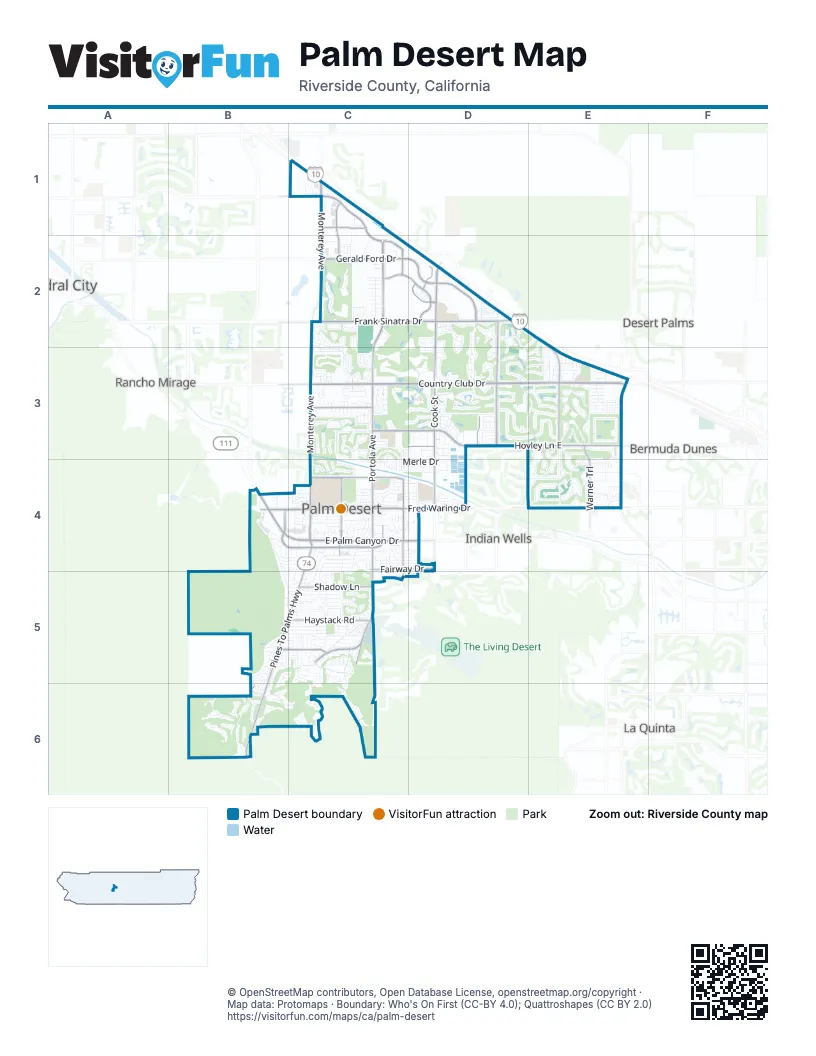
Street index of Palm Desert
Each street on the sheet and the grid squares it crosses.
- Monterey AvenueC1, C2, C3, C4
- East Palm Canyon DriveB4, C4, D4
- Pines To Palms HighwayC4, B5, C5, B6
- Portola AvenueC2, C3, C4, C5
- Country Club DriveC3, D3, E3, B6
- Fred Waring DriveB4, C4, D4, E4
- Cook StreetD2, D3, D4
- Hovley Lane EastC3, D3, E3
- Gerald Ford DriveC2, D2
- Frank Sinatra DriveC2, D2
- Dinah Shore DriveC1, C2
- Washington StreetE3, E4
- Tamarisk Row DriveD2, E2, E3
- Oasis Club DriveE3
- Carlotta DriveD3
- Pennsylvania AvenueE3
- El PaseoB4, C4
- El Dorado DriveD2, D3
- Magnesia Falls DriveC4
- College DriveC2, D2
- San Pablo AvenueC4
- Deep Canyon RoadC4, C5
- Mesa View DriveB5, C5
- Haystack RoadC5
- University Park DriveD2
- Warner TrailE3, E4
- Fairway DriveC4, D4
- Hovely Lane WestC3
- Shadow LaneC5
- Gateway DriveC1, C2
- Town Center WayB4
- Dick Kelly DriveC1
- 42nd AvenueD3, E3
- Pacific AvenueC2
- Technology DriveD2
- Cabrillo AvenueC4
- Grapevine StreetC5
- Palm Valley DriveD2, D3, E3
- Indian Ridge DriveD3, E3
- Palm Greens ParkwayC2, C3
- Shadow Mountain DriveC4, C5
- California DriveE3, E4
- Resorter BoulevardE3
- Preston TrailE3
- Gran ViaC3, C4
- Andreas Canyon DriveB5, C5, B6, C6
- Marrakesh DriveC5
- Irontree DriveC5
- Mariposa DriveC5
- Desert Willow DriveC3, D3
- Palm Desert Drive NorthC4
- Avenida del SolC3
- Desert Falls DriveD2, D3
- Silver Spur TrailC5
- Catalina WayC4
- Sweetwater DriveD2, D3
- Sandpiper StreetB4, C4
- Desert Falls Drive NorthD2
- Canyon View DriveC5, C6
- Bouquet Canyon DriveD3
- Desert Falls Drive EastD2, D3
- Alessandro DriveC4
- Running Springs DriveD3
- Canyon DriveB6, C6
- Joshua Tree StreetC4, C5
- Santa Rosa WayC4
- Camino Arroyo NorthC3
- The Lakes DriveD3
- Tennessee AvenueE4
- Metate PlaceB6
- Michigan DriveE3
- Painters PathB4
- San Pasqual AvenueC4
- Desert Greens Drive EastC2, C3
- Edgehill DriveB4, B5, C5
- San Luis Rey AvenueC4, C5
- Mesa Grande DriveD3, E3
- Merle DriveC4, D4
- De Anza WayC4
- Shepherd LaneC2
- Boxthorn LaneC5
- Conejo CircleC3, C4
- Kansas StreetE3, E4
- Amir DriveC5
- Shadow Ridge RoadC2
- Florida AvenueE4
- Parkview DriveB4, C4
- Upper Way WestB5
- Plaza del SolC3
- Willow StreetC5
- Verde WayC3
- Calliandra StreetC5
- Arrowhead DriveE3
- Calle de Los CampesinosB5
- Kiva DriveB6
- Palm Desert DriveC4
- Mission Creek DriveE3
- Mountain View AvenueC4, E4
- Ocotillo DriveC4, C5
- Old Prospector TrailC5, D5
- Ironwood StreetC4, C5
- Virginia AvenueE4
- Tomahawk DriveD3, E3
- Mesquite HillsB6
- New York AvenueE4
- Bursera WayC5
- Camino Arroyo SouthC3, C4
- Pinehurst LaneD3
- Chaparral DriveC3
- Candlewood StreetC4, D4
- Bougainvillea CircleD3
- Fairway Dunes RoadC2
- Club DriveD3
- Adobe Springs DriveC2, C3
- Inverness WayE3
- Tandika Trail NorthD2, D3
- Frank Feltrop CircleC5
- Regency WayE2, E3
- Sagewood DriveC3
- Bel Air RoadB5, C5
- Gold Canyon DriveD3, E3
- Angels Camp RoadC3, C4
- Desert Greens Drive NorthC2
- Las LomasC3
- Stone Eagle DriveB5
- Castellana SouthC4
- Skyward WayB5, C5
- Willow Lake DriveC3
- Desert Holly DriveE3
- South Cliff RoadB5
- Vista Royale DriveD2
- Wisteria DriveE2, D3, E3
- San Gorgonio WayC4
- Somera RoadB5, C5
- Texas AvenueE4
- Sun Corral TrailC5
- Alamo DriveC5
- Missouri DriveE4
- Snow Creek CanyonD3
- Gary AvenueC4, D4
- Panorama DriveC4, C5
- Foxtail LaneC5
- White Horse TrailD3
- Desert Greens Drive SouthC3
- Vista Lago Circle NorthD2, D3
- Desert Flower DriveB5
- Desert Heights Circle SouthC5
- Verba Santa DriveC4, C5
- Fairhaven DriveC4
- Calle Las Brisas SouthE4
- Toni DriveC1
- Tava LaneD3
- San Anselmo AvenueC4
- Rutledge WayC4
- Buckboard TrailC5
- Nasturtium WayD2, E2, D3
- Retreat CircleC2
- San RemoC3
- Sierra Madre SouthC3
- Cabazon Peak DriveC2
- Desert Lily DriveC5
- Acacia DriveC4
- Abronia TrailC4
- Red Arrow TrailD3, E3
- Barington DriveE3
- Pitahaya StreetB4, C4
- Cahuilla FallsB5, C5, B6
- Delaware PlaceE4
- Tamarisk StreetC5
- Bright Rock DriveD3
- Avondale DriveD3
- Pinyon StreetC4
- Lookout DriveD3
- Via TuscanyC3
- Rembrandt ParkwayC2
- Goleta AvenueC4
- Juniper StreetC4
- Turqueries AvenueE3, E4
- Sweet Pea WayD3
- Aster DriveC4
- Elkhorn TrailE4
- Vista PassB4, B5, C5
- Tandika Trail SouthD3
- Crocus LaneD2
- Guadalupe AvenueC4
- Desert Fern LaneB5, B6
- Eastwood LaneE3
- Hollyhock DriveD3, E3
- Oklahoma AvenueE4
- Netas DriveB6
- Driftwood DriveC4, D4
- Lost River DriveD3
- San Nicholas AvenueC4
- Bay Hill WayE3
- Cortesia WayC1, C2
- Agave LaneC5
- Morocco RoadE3
- Hawk Hill TrailE3
- Quicksilver StreetC4
- Tekis PlaceB6
- Box Canyon TrailE3
- Wisconsin AvenueE3, E4
- Homestead RoadB5, C5
- Larrea StreetC4
- Daffodil DriveD3, E3
- Via del PellegrinoC3
- Desert Circle DriveC5
- Fire Dance LaneE3
- Liolios DriveE3, E4
- Clubhouse WayD3, E3
- Summit CoveC6
- Maximo WayC3
- Desert Falls ParkwayD3
- Zircon Circle EastC3, C4
- Leslie AvenueC4, D4
- Casbah WayE3
- Moronga Canyon DriveC3
- Rose Ridge DriveC2
- Manzanita DriveC3, B4
- Chicory StreetC4
- Phyllis Jackson LaneD4
- Desert Greens Drive WestC2
- Palm Lake DriveD4
- La Costa Circle EastE3
- Julie LaneC2
- Pinncale CrestC6
- Deer Grass DriveC5
- Burroweed LaneC4, C5
- Desert Falls CircleD3
- Sand Dune DriveE3, E4
- Palace DriveE3
- Velardo DriveC4
- Primrose DriveC4
- Quercus LaneC5
- Red River RoadD3
- Wanish PlaceB6
- Sheryl AvenueD4
- Rolling Knoll DriveB5
- Kybar RoadE4
- LargoD3
- Gladiolus LaneD2, D3
- Honeysuckle DriveD3
- Tepin WayB6
- Wikil PlaceB6
- Broken Arrow TrailC5
- Paseo Del CorazonD2
- Paseo PrimaveraC3
- Azurite Circle EastC3, C4
- Fleetwood CircleC4
- Woodhaven Drive SouthE3
- Joni DriveD3
- Serena DriveC3
- Narcissus WayD3
- Amber StreetC5
- Indiana AvenueE4
- Illinois AvenueE4
- Crest Lake DriveD3
- Woodhaven Drive WestE3
- Menil PlaceB6
- Fawn Springs DriveC2
- Indian Springs Drive NorthB5
- Presidio PlaceC3
- Aztec RoadD4
- Blue River DriveD3
- Club Circle DriveC4
- Deer Spring WayD3
- Woodhaven Drive EastE3
- Edinborough StreetE4
- San Jose AvenueC4
- Calle de VeranoC4
- El Menara CircleC5
- Palm Desert Drive SouthC4
- Painted Mountain LaneC2
- San Carlos AvenueC4
- Lake VistaC5
- Woodhaven Drive NorthE3
- Covered Wagon TrailC5
- Calle Las Brisas WestE4
- Devils Canyon DriveC2
- Shadow Lake DriveC4
- Wild Horse DriveD3
- Zircon Circle WestC3, C4
- Beavertail StreetB4, C4
- Don Miguel CircleC3
- Kentucky AvenueE4
- Calle BisqueC3
- Ciega Creek DriveC3
- Sandcastle LaneD3
- Rocky CreekC6
- Desert Mirage DriveD2
- La Costa Circle WestE3
- Tamit PlaceB6
- Erin StreetC4
- El AgadirC5
- Old Stone Trail.B5
- Little Bend TrailC5
- Terraza DriveC3
- Camino Arroyo PlaceC3
- Desert Bloom TrailC5
- Sutters Mill RoadC3, C4
Things to do on the Palm Desert map
Places on the map
- Avondale Golf Club
- Big Horn Golf Club - Canyons Course
- Big Horn Golf Club - Mountains Course
- Cahuilla Hills Park
- Cap Homme / Ralph Adams Park
- Chaparral Country Club
- Civic Center
- Civic Center Park
- Costco
- Desert Crossing Shopping Center
- Desert Falls Country Club
- Desert Gateway
- Desert Springs
- Desert Springs Marketplace
- Desert Willow Golf Resort
- DSRT Surf
- Freedom Park
- G. George and Kathleen S. Fox Hiking Park
- Gardens On El Paseo
- Hovley Soccer Park
- Indian Ridge Country Club
- Ironwood Park
- JW Marriott Desert Springs Resort & Spa
- Marrakesh Country Club
- Moller’s Garden Center
- Monterey Country Club
- Oasis Country Club Golf Course
- Palm Desert Country Club
- Palm Desert Greens
- Palm Desert Resort and Country Club
- Palm Valley Country Club
- Portola Country Club
- Shadow Mountain Golf Club
- Shadow Ridge
- Stone Eagle
- Suncrest Country Club
- The Lakes Country Club
- The Shops at Palm Desert
- Woodhaven Golf Course
Next to Palm Desert
- Bermuda Dunes
- Cathedral City map
- Desert Palms
- Indian Wells
- La Quinta map
- Rancho Mirage map
© OpenStreetMap contributors, Open Database License, openstreetmap.org/copyright · Map data: Protomaps · Boundary: Who's On First (CC-BY 4.0); Quattroshapes (CC BY 2.0)















