

California map
Petaluma map
About 59,393 people live here (Census Bureau, 2024 estimate). The sheet's index lists 300 streets; Redwood Highway, Lakeville Highway and North McDowell Boulevard cross the most grid squares. Also on it: 101 North Brewing Company, Casa Grande High School and Corona Creek Elementary School.
Open the map (PDF, US Letter)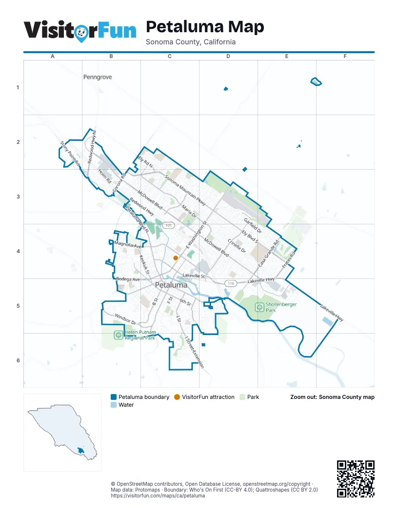
Street index of Petaluma
Each street on the sheet and the grid squares it crosses.
- Redwood HighwayA2, B2, B3, C3, C4, D4, D5
- Lakeville HighwayD4, E4, D5, E5, F5
- East Washington StreetD3, C4, D4
- Lakeville StreetC4, D4
- Bodega AvenueB5, C5
- Washington StreetC4, C5
- North McDowell BoulevardB2, B3, C3, C4
- Sonoma Mountain ParkwayB3, C3, D3
- Petaluma Boulevard NorthB2, B3, C4, C5
- South McDowell BoulevardC4, D4, E4, E5
- Ely Boulevard SouthD3, D4, E4
- Caulfield LaneD3, D4, D5
- Casa Grande RoadD4, E4, D5
- Payran StreetC4, D4
- Redwood Highway NorthB2
- Petaluma Boulevard SouthC5, D5
- Corona RoadB2, B3
- Stony Point RoadA2, A3, B3
- East Washington BoulevardD3
- West Payran StreetC4
- Petaluma Boulevard North EastB3
- Maria DriveC2, C3, D3, D4
- Frates RoadE4, E5
- Windsor DriveB5, C5
- B StreetB5, C5
- D StreetC4, C5
- Western AvenueB5, C5
- I StreetC5
- 6th StreetC5
- Rainier AvenueC3
- Keokuk StreetB4, C4, C5
- Mountain View AvenueC5, D5
- I Street ExtensionC5, C6
- Howard StreetB4, C4, C5
- Magnolia AvenueB4, C4
- Ely Road NorthB2, C2, C3
- East D StreetC4
- D Street ExtensionC5, C6
- Gossage AvenueB3, B4
- Garfield DriveD3, D4, E4
- Crinella DriveD4, E4
- Baywood DriveD4, D5
- Lakeville CircleE4
- Riesling RoadC2, C3
- Saint Francis DriveD4, D5
- Park Place DriveC3
- West StreetB4, C4
- Northstar DriveC3
- 5th StreetC5
- Daniel DriveD4
- McNear AvenueC5, D5
- Liberty StreetC4, C5
- Greenbriar CircleD4
- Falcon Ridge DriveE4
- F StreetC5
- Cherry StreetB4, C4
- G StreetC5
- Industrial AvenueB3
- Rainier CircleC3
- Sunnyslope RoadC5, C6
- Vallejo StreetC4
- Madison StreetC4
- Auto Center DriveB3
- Hopper StreetC4, C5, D5
- McGregor AvenueD4
- Keller StreetC4, C5
- Elm DriveB4
- Lindberg LaneC4, D4
- Castle DriveC3, D3
- Weaverly DriveD4
- East Madison StreetC3, D3, C4
- Kentucky StreetC4, C5
- Cypress DriveE5
- English StreetB5, C5
- Marylyn CircleD4, E4
- Baker StreetB5, C5
- Wilson StreetC4
- Sarkesian DriveD4
- 4th StreetC5
- Edith StreetC4
- Webster StreetB5, C5
- Sunnyslope AvenueC5
- Wood Sorrel DriveB3, C3
- Mission DriveC5, D5
- Sutter StreetD3, D4
- Acadia DriveC3
- Black Oak DriveC6
- 2nd StreetC5
- Ramona LaneD4
- C StreetC5
- West Haven WayB5
- Cerro Sonoma CircleE4
- Alta DriveD4
- Hayes LaneB5, C5
- 8th StreetC5
- 7th StreetC5
- Southpoint BoulevardB3, C3
- Upham StreetB5, C5
- Saint Augustine CircleD3, E3, E4
- Turtle Creek LaneD3
- Round Walk CircleC3
- Park LaneD4
- Lombardi AvenueD4
- Bassett StreetB5, C5
- Jacquelyn LaneD5
- San Rafael DriveD4, D5
- Jeffrey DriveD3, C4
- Lauren DriveD3, C4, D4
- Skyranch RoadD3
- Adobe Creek DriveE4
- Fair StreetB5, C5
- Holm RoadB2, B3
- Matzen Ranch CircleC3
- Del Oro CircleE4
- Oak StreetB4, C4
- Prospect StreetC4, B5
- Ponderosa DriveD4
- Banff WayC3
- Grevillia DriveC6
- Kent StreetB4, C4
- H StreetC5
- Madeira CircleC3
- Cader LaneE5
- Laurel StreetB4
- Country Club DriveD5
- Willow DriveD3
- Arlington DriveC4
- Schuman LaneB4
- Samuel DriveB4
- Walnut StreetB4, C4
- Albert WayD4
- 1st StreetC5
- Bordeaux DriveD3, D4
- Kenilworth DriveC4, D4
- North Webster StreetB4, B5
- Allen StreetE4
- Bond AvenueD4, E4, D5
- Casa Verde CircleE4
- Galland StreetB4, C4
- Sapphire StreetD5
- Gilrix StreetD3
- Holly LaneC4
- Sartori DriveE4
- Paula LaneB4
- Transport WayC3
- Joan DriveC3, D3, C4
- Draco DriveC3
- Zinfandel DriveC3
- Cross Creek StreetE4
- Rocca DriveC4
- Copeland StreetC4
- Redwood WayB2
- Kresky WayD4
- Andover WayB2, C2, B3
- Burlington DriveC4
- Professional DriveC3
- Eastside CircleD3, D4
- Pine View WayE5
- Meadowview DriveE3, D4, E4
- Olive StreetC5
- Louise DriveD4
- Monroe StreetC3, D3
- E StreetC5
- Wren DriveE4
- Bantam WayB4, B5
- Glenwood DriveD4
- Jefferson StreetC4
- Stuart DriveC4, D4
- Hidden Valley DriveE4
- Gnoss ConcourseC4
- McNear CircleD5
- Marian WayD4
- Jade StreetD5
- Yarberry DriveB3, C3
- Candlewood DriveC3
- Hill BoulevardB5, C5
- Linnet LaneD3
- Grant AvenueC5
- Sunrise ParkwayC3
- Tulare StreetC3
- Rebecca DriveB4
- Amber WayB4
- Sycamore LaneB4, C4
- Graylawn AvenueC4
- Redwood CircleD3
- Dana StreetB5
- Almanor StreetC3
- Appaloosa DriveD3
- Petaluma WayB3
- Juliet DriveD4, E4
- Ridgeview DriveC6
- Woodside CircleC3
- Oakwood DriveC3
- Jess AvenueC4
- Morning Glory DriveB3, C3
- Post StreetC5
- Sierra DriveD4
- Inverness DriveC3
- Westridge DriveC6
- Corporate CircleE5
- Coronado DriveC4, D4
- White Oak CircleB4, C4
- Cortez DriveC4, D4
- Calle RancheroE4
- La Cresta DriveB5
- Weatherby WayD3, D4
- Quarry StreetC2
- Stonehenge WayC2, B3, C3
- Larch DriveB4
- Spyglass RoadE4
- Berrydale DriveD4
- Sequoia DriveC3
- Chardonnay CircleC3
- North Napa DriveB3
- Serpilio WayC3
- Middlefield DriveD5
- Flanigan WayC3
- Anna WayD4
- Raymond HeightsC5
- Royal Oak DriveC3
- Cambridge LaneB5
- Pine AvenueD3
- Marina AvenueD5
- River Pine CircleE4
- Douglas StreetC5
- Hogwarts CircleB3
- Santa Clara LaneD5
- North Water StreetC4
- Pacific AvenueD4
- Clydesdale WayD3
- Stanley StreetC5
- Capri AvenueC3
- Telephone AlleyC4, C5
- Harrison StreetD3
- Pepper School AlleyC4, C5
- Stone Creek DriveC2, C3
- El Paseo DriveB5
- Putnam WayD4
- Eastwood DriveD3
- Ely Road SouthE4
- Colombard RoadC3
- Heather LaneC2
- Lansdowne WayC2
- Sunny Hill DriveC5
- Culpepper DriveC3
- Photinia PlaceC6
- Noriel LaneD3
- Aspen WayD4
- Elizabeth DriveD4
- Parkland WayD3
- Quail DriveD4
- Debra DriveD4
- Bungalow LaneD4
- Annetta DriveD4
- Mauro Pietro DriveB3
- Sleepy Hollow LaneD3
- Brighton View CircleD5
- San Marino DriveD4
- Tanager LaneD4
- Wallenberg WayC5, C6
- Novak DriveC3, D4
- Winchester LaneC2
- Colwood DriveD4
- Trellis LaneD4
- Astoria CircleD4
- Iverson WayB5
- Vista LaneD3
- Fairground DriveC4
- Pheasant DriveD4
- Rio Nido WayE4
- Primrose DriveC2
- Oneel DriveD4
- Acorn CircleC4
- Cindy LaneB4
- Wieling WayD4
- Sandstone DriveC2
- Scott StreetB2, B3
- Selmart LaneC3
- Ross StreetB2, B3
- Catalpa WayD4
- Chehalis DriveC3, D3
- Clegg StreetB3
- Village East DriveD4, E4
- Paseo del OlmoC4
- Technology LaneD5
- Appaloosa CircleD3
- Michael DriveB3
- Perry LaneD5
- Rancho WayD4
- Johnson DriveC4
- Lynch Creek WayC3, C4
- East Sunnyslope RoadC5
- Executive DriveD3
- Rancho Bonito CircleE4
- Rand StreetB3
- Vista View PlaceC6
- Hartman LaneC2
- Suncrest Hill DriveC5, C6
- Kimberly WayD5
- Creekside DriveD3, D4
Places on the map
- 101 North Brewing Company
- Casa Grande High School
- Corona Creek Elementary School
- East Washington Place
- Friedman's Home Improvement
- Glennbrook Park
- Golden Eagle Shopping Center
- Hoppy Hopkins Memorial Research Library
- Kenilworth Junior High School
- KOA San Francisco North (Petaluma)
- La Tercera Elementary School
- Leghorn's Park
- Loma Vista Immersion Academy
- Lucchesi Park
- McDowell Elementary School
- McDowell Park
- McKinley Elementary School
- McNear Park
- Miwok Valley Elementary School
- Petaluma High School
- Petaluma Junior High School
- Petaluma Municipal Airport
- Petaluma Reservoir
- Petaluma Valley Hospital
- Petaluma Village Premium Outlets
- Plaza South Shopping Center
- Prince Park
- Rocky Memorial Dog Park
- Rooster Run Golf Club
- Saint Vincent High School
- Shollenberger Park
- Steamer Landing Park
- Sunrise Park
- The UPS Store
- Valley Vista Elementary School
- Washington Square
- Westridge Os
- Westridge Park & Open Space
- Wiseman Park
Next to Petaluma
- Penngrove
© OpenStreetMap contributors, Open Database License, openstreetmap.org/copyright · Map data: Protomaps · Boundary: Who's On First (CC-BY 4.0); Quattroshapes (CC BY 2.0)