

California map
San Bernardino map
About 224,775 people live here (Census Bureau, 2024 estimate). The sheet's index lists 215 streets; Cajon Boulevard, Foothill Freeway and East 3rd Street cross the most grid squares. Also on it: Al Guhin Park, Alder Square and Amazon.
Open the map (PDF, US Letter)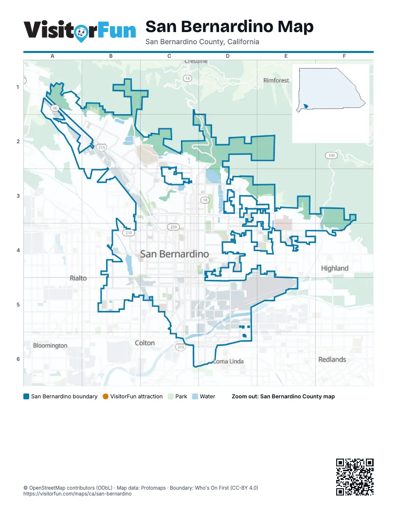
Street index of San Bernardino
Each street on the sheet and the grid squares it crosses.
- Cajon BoulevardA1, A2, B2, B3, C3, C4
- Rim of the World HighwayC1, C2, D2
- Kendall DriveA2, B2, C3
- Little League DriveA2, B2
- Barstow FreewayB2, B3, C3, C4
- Campus ParkwayB2
- Cloudland Truck TrailB2
- Devils Canyon RoadB2
- Hallmark ParkwayB2, B3
- Industrial ParkwayB2
- Institution RoadB2
- New Pine AvenueB2
- North Pine AvenueB2
- Northpark BoulevardB2
- Palm AvenueB2, E4
- University ParkwayB2, C2, B3, B4
- West Belmont AvenueB2
- West Kendall DriveB2
- West Little League DriveB2
- West Northpark BoulevardB2, C2
- East Campus CircleC2
- Electric AvenueC2, C3
- F StreetC2, C3
- Hill DriveC2
- Little Mountain DriveC2, C3
- Mountain DriveC2, C3
- North Campus CircleC2
- North H StreetC2, C3, C4, C5
- North Waterman AvenueD2, D3, D4, D5
- Old Waterman Canyon RoadD2
- Waterman AvenueD2
- California StreetB3, B4
- Darby StreetB3
- State StreetB3
- West 27th StreetB3, C3, C4
- West College AvenueB3
- 30th StreetC3, D3
- 40th StreetC3
- 48th StreetC3, D3
- E StreetC3, C4, C5
- East 30th StreetC3, D3
- East 34th StreetC3, D3
- East 40th StreetC3, D3
- East Marshall BoulevardC3, D3
- East Parkdale DriveC3, D3
- East Parkdale StreetC3, D3
- Foothill FreewayC3, D3, B4, C4, E4
- H StreetC3, C4
- Leuzinger DriveC3
- Miramonte DriveC3
- North Arrowhead AvenueC3, C4, C5
- North E StreetC3, C4, C5
- North Electric AvenueC3
- North Mount Vernon AvenueC3, C4, C5
- North Mountain View AvenueC3, C4, C5
- North Muscupiabe DriveC3, C4
- North Shandin Hills DriveC3
- North Sierra WayC3, C4, C5
- Shandin Hills CircleC3
- Sierra WayC3, D3, C5
- West 30th StreetC3
- West 34th StreetC3
- West 37th StreetC3
- West 40th StreetC3
- West Marshall BoulevardC3
- West Parkdale DriveC3
- West Thompson PlaceC3
- 39th Street EastD3
- Date PlaceD3
- Date Street EastD3, E3
- East 39th StreetD3
- East Lynwood DriveD3, E3
- Foothill DriveD3, E3
- Harrison Street NorthD3
- Marshall BoulevardD3, E3
- Mountain Avenue NorthD3
- North Del Rosa AvenueD3, D4
- North Golden AvenueD3, D4
- North Mountain AvenueD3
- North Valencia AvenueD3, D4
- Sterling AvenueD3, D4
- Valencia AvenueD3, D4
- Lynwood DriveE3
- North Orange StreetE3, E4
- Victoria AvenueE3, E4
- Steve Faris Memorial HighwayF3, E4, F4
- 20th StreetB4
- 4th StreetB4, B5
- Baseline RoadB4
- East Baseline RoadB4
- East Foothill BoulevardB4
- East Highland AvenueB4, C4, D4, E4
- Etiwanda AvenueB4
- North California StreetB4
- North Eucalyptus AvenueB4
- North Macy StreetB4
- North Meridian AvenueB4, B5
- North Rancho AvenueB4, B5
- North State StreetB4
- West 16th StreetB4, C4
- West 5th StreetB4, C4, D4, E4
- West Baseline RoadB4
- West Baseline StreetB4, C4
- West Foothill BoulevardB4, B5
- West Highland AvenueB4, C4
- 5th StreetC4
- East 5th StreetC4, D4
- East 9th StreetC4, D4
- East Baseline StreetC4, D4
- Massachusetts AvenueC4
- Medical Center DriveC4
- North D StreetC4, C5
- North G StreetC4, C5
- North Massachusetts AvenueC4
- San Bernardino FreewayC4, C5, C6
- West 13th StreetC4
- West 21st StreetC4
- West 6th StreetC4
- West 7th StreetC4
- West 9th StreetC4
- Western AvenueC4
- Base Line StreetD4
- Del Rosa AvenueD4
- Del Rosa DriveD4, D5
- East 21st StreetD4
- East 3rd StreetD4, E4, C5, D5, E5
- East 6th StreetD4, E4
- East Gilbert StreetD4
- East Olive StreetD4
- East Pumalo StreetD4, E4
- North Sterling AvenueD4
- North Tippecanoe AvenueD4, D5
- Pacific StreetD4, E4
- Perris Hill Park RoadD4
- Pumalo StreetD4
- Arden AvenueE4
- Atlantic AvenueE4
- Central AvenueE4, D5, E5
- Highland AvenueE4, F4
- North Palm AvenueE4
- Orange StreetE4
- Boulder AvenueF4
- East Merrill AvenueB5
- East Rialto AvenueB5, C5, D5
- Meridian StreetB5
- Mill StreetB5, C5
- North Pepper AvenueB5
- Rancho AvenueB5
- South Eucalyptus AvenueB5
- South Meridian AvenueB5
- South Pepper AvenueB5
- South Rancho AvenueB5
- West 4th StreetB5, C5
- West Mill StreetB5, C5
- West Randall AvenueB5
- West Rialto AvenueB5, C5
- Auto Plaza DriveC5
- Cabrera AvenueC5
- D StreetC5
- East 2nd StreetC5, D5
- East Central AvenueC5, D5
- East Mill StreetC5, D5
- Inland Center DriveC5
- North Colton AvenueC5
- Orange Show RoadC5, D5
- South Arrowhead AvenueC5
- South Auto Plaza DriveC5
- South D StreetC5
- South E StreetC5, C6
- South G StreetC5
- South I StreetC5
- South K StreetC5
- South Mount Vernon AvenueC5
- South Sierra WayC5
- West 2nd StreetC5
- West 3rd StreetC5
- West Central AvenueC5
- West Grant AvenueC5
- West Orange Show RoadC5
- Almond AvenueD5
- East Orange Show RoadD5
- East San Bernardino AvenueD5
- Harry Shepard BoulevardD5
- Lena RoadD5
- Mountain View AvenueD5, D6
- North Lena RoadD5
- Richardson StreetD5
- South del Rosa DriveD5
- South Del Rosa DriveD5
- South Lena RoadD5
- South Richardson StreetD5, D6
- South Tippecanoe AvenueD5, D6
- South Waterman AvenueD5, D6
- 3rd StreetE5
- Alabama StreetE5
- East Hospitality LaneC6, D6
- East Redlands BoulevardC6, D6
- East Washington StreetC6, D6
- Fairway DriveC6
- Pearl Harbor Memorial HighwayC6, D6
- South Hunts LaneC6
- West Hospitality LaneC6
- West Redlands BoulevardC6
- Barton RoadD6
- Coulston StreetD6
- East Brier DriveD6
- East Carnegie DriveD6
- East Coulston StreetD6
- East Vanderbilt WayD6
- East Wier RoadD6
- Hardt StreetD6
- Harriman PlaceD6
- South Carnegie DriveD6
- South Wier RoadD6
- Wier RoadD6
Places on the map
- Al Guhin Park
- Alder Square
- Amazon
- Amazon Air Hub
- Amazon ONT2
- Amazon ONT5
- Amazon SBD2
- Amazon SBD3
- Andy Jackson Airpark
- Anne Shirrells Park
- Aquinas High School
- Arrow Maintenance Facility
- Arrowhead Country Club
- Arrowhead Grove
- Arrowview Middle School
- Arroyo Valley High School
- Badger Hill
- Badger Percolation Basin
- Bing Wong Elementary
- Blair Park
- Blast Soccer Complex
- BNSF B-Yard Vehicle Facility
- BNSF San Bernardino Intermodal Facility
- Bob Holcomb Elementary School
- Brier place
- Cajon High School
- California State University, San Bernardino
- Campus Crossroads
- Capital Drum
- Central Detention Center
- Chaparral Motorsports
- Colony Park
- Community Hospital of San Bernardino
- Community Medical Plaza
- Crestview Terrace
- Curtis Middle School
- Del Vallejo Middle School
- Delman Heights Park
- Devils Canyon Percolation Basins
- Diocese of San Bernardino
Next to San Bernardino
- Bloomington
- Colton
- Crestline
- Highland
- Loma Linda
- Redlands
- Rialto
- Rimforest
© OpenStreetMap contributors (ODbL) · Map data: Protomaps · Boundary: Who's On First (CC-BY 4.0)