

California map
Temecula map
About 112,431 people live here (Census Bureau, 2024 estimate). The sheet's index lists 300 streets; Ynez Road, Margarita Road and Escondido Freeway cross the most grid squares. Things to do inside the boundary: Promenade Temecula, Temecula Valley and Temecula Valley Wine Country.
Open the map (PDF, US Letter)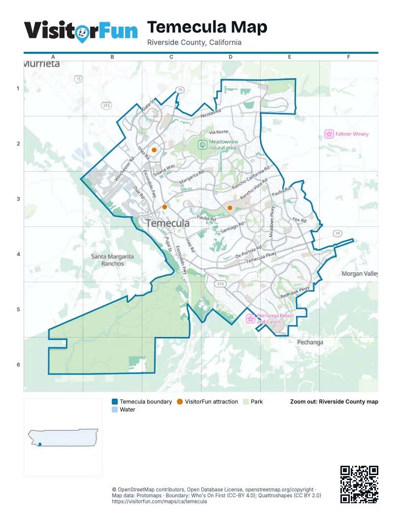
Street index of Temecula
Each street on the sheet and the grid squares it crosses.
- Escondido FreewayB2, C2, C3, C4, C5
- Avocado HighwayC5
- Butterfield Stage RoadE1, E2, E3, E4, F4
- Ynez RoadB1, B2, C2, C3, C4, D4
- Temecula ParkwayC4, D4, E4
- Rancho California RoadE2, B3, C3, D3, E3
- Winchester RoadC1, B2, C2, B3
- Pechanga ParkwayD4, D5, E5
- Jefferson AvenueB2, B3, C3
- Diaz RoadB2, B3, C3
- Murrieta Hot Springs RoadD1, E1
- Pu'eska Mountain ParkwayC3, C4
- Via IndustriaB3
- Western BypassB3, C4
- Washington AvenueB2
- Margarita RoadC1, C2, D2, C3, D3, D4
- Meadows ParkwayD2, D3, E3, E4
- Redhawk ParkwayD4, E4, E5
- De Portola RoadE3, F3, D4, E4
- Pauba RoadC3, D3, E3
- Rancho Vista RoadC3, D3, E3
- Vail Ranch ParkwayE4, E5
- Nicolas RoadC1, D1, E1, C2
- Santiago RoadD3, C4, D4
- Old Town Front StreetC3, C4
- La Serena WayD2, D3
- Date StreetB1, C1, B2
- Solana WayC2, C3
- Rainbow Canyon RoadD4, D5
- Overland DriveB2, C2, B3
- Deer Hollow WayE5
- Wolf Valley RoadD5, E5
- Nighthawk PassE4, F4
- Via SaltioD4, E4, D5, E5
- Peppercorn DriveE5
- La Paz StreetC4
- Apis RoadE4
- Jackson AvenueB1
- Via NorteC2, D2
- Del Rey RoadC2, D2
- Campanula WayE4
- Sommers BendE1
- North General Kearny RoadC1, D1, C2
- Loma Linda RoadD4, D5
- Crowne Hill DriveE3
- Promenade Chardonnay HillsD2, E2
- Mira Loma DriveC3, D3
- Jedediah Smith RoadD4
- Business Park DriveB3, C3
- Calle MedusaD1, D2
- Honors DriveD3
- Sunny Meadows DriveE3, E4
- Ring RoadC2
- Village RoadB1, C1, B2, C2
- Amarita WayD3, D4
- Pujol StreetC3, C4
- Temeku DriveD2, D3
- Wolf Store RoadE4
- Avenida AlvaradoB3
- Wolf Creek Drive SouthD5, E5
- Rio NedoB3
- Camino EstriboC4, C5
- Montelegro WayD3, E3, D4, E4
- Walcott LaneD1, D2
- Leena WayE4
- Royal Berkdale DriveD3
- Wolf Creek Drive NorthD5
- Peach Tree StreetE5
- Via Rio TemeculaD4, E4
- Harveston DriveC1
- Pio Pico RoadD4
- Channel StreetE4, F4
- Overland TrailE4
- Via la VidaC2, C3
- Calle Pina ColadaC2, D2
- Del Rio RoadB3, C3
- Calle GirasolD1
- Commerce Center DriveB2, B3, C3
- Motor Car ParkwayC2, C3
- Royal Crest PlaceE3
- Preece LaneC3, C4
- Dendy ParkwayB2, B3
- Pechanga RoadE5
- County Center DriveB2, C2
- Temecula Center DriveB2
- Enterprise Circle NorthB2
- Rustic Glen DriveC1
- Seraphina RoadD1
- Mercedes StreetC3, C4
- Equity DriveB2, C2
- Enterprise Circle WestB2, B3
- Anza RoadE5
- Ridge Park DriveB3, C3
- 1st StreetC4
- Moraga RoadC3
- Avenida De MissionesD4
- Yukon RoadD3
- Felix Valdez AvenueC3
- McCabe DriveE3
- Moreno RoadC3
- Harveston WayC2
- Via MontezumaB3, C3
- Avenida BarcaC2, D2, D3
- Old Kent RoadE3
- Main StreetC3, C4
- Primrose AvenueE5
- Verdes LaneC2
- Madison AvenueB2
- Redwood RoadD4, D5
- 6th StreetC3, C4
- Lakeview RoadB1, C1
- Rocky Bar DriveE5
- Calle ChaposD1, E1
- Via Las ColinasC3
- Rancho WayB3, C3
- Single Oak DriveB3, C3
- Vincent Moraga DriveC3
- Jerez LaneE3
- Lyndie LaneC3
- Country Glen WayD4
- Landings RoadC1, C2
- Promenade WayC2
- Via RamiD3
- Rancho Pueblo RoadD4
- Roick DriveB3
- Promenade Mall EastC2
- Buecking DriveB2
- Promenade Mall SouthC2
- Promenade Mall NorthC2
- Rita WayD1
- Tee DriveD3
- El Chimisal RoadE5
- Sanborn AvenueB2
- Mahlon Vail RoadE4
- 2nd StreetC4
- Promenade Mall WestC2
- Harveston School RoadC1
- Rider WayB2, B3
- Dona LynoraD4
- Willows AvenueC1
- Joseph RoadD1
- Vallejo AvenueC4, D4
- SD Aqueduct service road (private)C4, B5, B6
- Humber DriveC3, D3
- Daybrook TerraceE1
- Via CordobaD4, E4, D5
- Cabrillo AvenueC4, D4
- Liefer RoadD1
- Fox RoadE3
- East Loma Linda RoadD5
- Avenida del ReposoD2
- Agena StreetC3, D3
- Clubhouse DriveD4, D5
- Bucle PradoB2
- Wolfe StreetE3
- Roripaugh RoadC2
- Remington AvenueB2, B3
- Verbena WayE1
- Dayspring WayE1
- Zevo DriveB3
- Riverside County Flood ControlC1, D1, C2
- John Warner RoadC4, D4
- Lolita RoadD4
- Sharon StreetE5
- Calle de VelardoD4
- Sierra Madre DriveC1, D1
- Paseo GoletaD3
- Tierra Vista RoadC3
- Enfield LaneD1, D2
- Oak Cliff DriveC1
- Kahwea RoadD2
- Avenida Buena SuerteD2
- Classic WayD5
- Deer Meadow RoadC2, D2
- Paseo de Las OlasD3
- Romance PlaceE5
- Camino MareaD3, E3
- Camino Del SolE4
- Via La ColoradaE5
- Cosmic DriveC3, D3
- Ynez CourtC3
- Cara WayC3
- Pechanga DriveC4, D4
- Wyandotte StreetE3
- Camino Piedra RojoE4
- Avenida de la ReinaD3
- Strawberry Tree LaneD4, D5
- Calle ResacaE2, E3
- Southern Cross RoadD3
- Camelot RoadE3
- San Pasqual RoadD2
- Campo DriveE3
- Calle KatherineD2
- Abbey RoadF4
- Crystalaire DriveD3
- Riverton LaneD1, D2
- Green Tree RoadD3, E3
- Camino RubiE5
- Carmelita CircleC2
- Royal Oaks DriveD2, D3
- DLR DriveC3
- Villa Alturas StreetC3
- Valle Olvera StreetC2
- Avenida Cima del SolC3
- Lupine DriveE1
- Brassie LaneD3
- Sagewood RidgeE1
- Corte CanteraC2, C3
- Rancho Community WayD4
- Via Puesta del SolC3
- Rainbow Creek DriveC1
- Via de StelloE4
- Valentino WayE4
- Calle BallentineD3, E3
- Alcoba DriveE4
- Tehachapi PassE4, E5
- Cebu DriveD2
- Calle TorcidaD2
- Holly LaneD2
- Sweetwater CircleD1
- Tiburcio DriveE4, E5
- Hislop WayE4
- Cupeno LaneC4, D4
- Heitz LaneD2
- Chantemar WayC2
- Congressional DriveD2
- Modena DriveE3, E4
- Rhine AvenueE5
- Santa Cecilia DriveC3, D3
- Milano RoadD1, C2, D2
- Yorba AvenueC4, D4
- Larkspur TerraceE1
- Muirfield DriveD4, D5
- San Marco DriveE3
- Manzano DriveD4
- Calle BalarezaD4, E4
- Paseo ParallonE4
- Calle RedondelaD4
- Drymen StreetE5
- Dodaro DriveE3
- Pescado DriveD4
- Tulley Ranch RoadE4
- Caminito OsunaE5
- Tioga StreetE4, E5
- Embassy AvenueE5
- Corte AlmeriaD3, E3, E4
- Paseo del CieloC2, D2
- Wgasa PlaceD2
- East Vallejo AvenueD4
- Country View RoadD1
- Via SeronD4, E4
- Hillstone StreetE1
- Jon Christian PlaceC2
- Regina DriveE4
- Sonder WayE1
- Via GilbertoD5
- Milky Way DriveC3, D3
- Saint CroixE2
- Rancho HighlandC3
- Via San CarlosD4
- Camino Campos VerdeC2
- Camino NunezE3
- Rue JadotD2, E2
- Calle HalconC3
- Sandhill LaneD3
- Balboa DriveC2
- Corte MislancaE5
- Via AngelesE3, E4
- Calabro StreetE3, E4
- Butternut DriveC3, C4
- Camino del EsteD2
- Corte CabreraD3
- Via PueblaE5
- Sunningdale DriveD2
- Avenida Vista LaderaC2, C3
- Ashburn RoadD3
- Calle NoveldaD3, D4
- Camino RosalesD5, E5
- Skyline DriveD1
- Hupa DriveE4
- Roripaugh Valley RoadE1
- Paseo GallanteE5
- Favara DriveE4
- Masters DriveD4, D5
- Stonewood RoadC3
- Camino CasanaE3
- Wellington CircleD2
- Hickory PlaceD5
- Odessa DriveC2
- Calle NacidoC3, C4
- Vine StreetE5
- Johnston DriveE4
- Via el GrecoD3
- Pasadena DriveB1, B2, C2
- Willow Run RoadD2
- Enterprise Circle SouthB2
- Via SabinoE3, E4
- Colina Verde StreetC3, D3
- Paraguay DriveE3
- Calle Los MochisE5
Things to do on the Temecula map
Places on the map
- Abby Reinke Elementary School
- Bel Villaggio
- Bella Linda
- Bulldog Athletic Fields
- Chaparral High School
- Crystal Ridge
- Extra Space Storage
- Great Oak High School
- Johnson Ranch
- Linfield Christian School
- Meadowview natural area
- North Jefferson
- Old Town
- Old Town Temecula
- Palm Plaza Shopping Center
- Palomar Village
- Paseo del Sol
- Promenade Temecula
- Rancho Temecula Town Center
- Redhawk Golf Club
- Redhawk Towne Center
- Ronald Reagan Sports Park
- Santa Margarita Ecological Reserve
- Temecula Auto Mall
- Temecula Creek Inn Golf Course
- Temecula Gateway
- Temecula Town Center
- Temecula Valley High School
- Temecula Valley Hospital
- The Legends Golf Club
- The Promenade
- Tower Plaza Center
- Vail Ranch Park
- Vail Ranch Shopping Center
- Villages at Paseo del Sol
- Vintage Hills
- Westside
- Wild Rivers Temecula Site
- Winchester Highlands
- Winchester Meadows
Next to Temecula
- Morgan Valley
- Murrieta map
- Pechanga
- Santa Margarita Ranchos
© OpenStreetMap contributors, Open Database License, openstreetmap.org/copyright · Map data: Protomaps · Boundary: Who's On First (CC-BY 4.0); Quattroshapes (CC BY 2.0)















