

California map
Truckee map
About 17,240 people live here (Census Bureau, 2024 estimate). The sheet's index lists 300 streets; Alan S. Hart Freeway, Donner Pass Road and Glenshire Drive cross the most grid squares. Things to do inside the boundary: Coldstream Adventures.
Open the map (PDF, US Letter)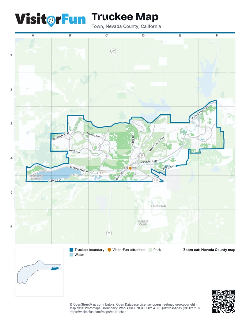
Street index of Truckee
Each street on the sheet and the grid squares it crosses.
- Alan S. Hart FreewayF2, E3, F3, A4, B4, C4, D4
- Northwoods BoulevardB3, C3, B4, C4
- Donner Pass RoadA4, B4, C4, D4, A5
- Glenshire DriveE3, F3, D4, E4, F4
- Brockway RoadD4, D5
- West River StreetC4, D4, C5
- Truckee WayD4
- Bridge StreetD4
- State Route 89C4
- McIver CrossingC4
- Hirschdale RoadF2
- Alder Creek RoadB3, C3, D3
- South Shore DriveA4, B4, A5, B5
- Prosser Dam RoadD3, E3, D4
- Hansel AvenueB3, C3, C4
- Lausanne WayC4
- Schussing WayC3, C4
- Dorchester DriveE3, F3
- East Alder Creek RoadD3
- Saint Bernard DriveC3, C4
- Rainbow DriveD3
- Snowpeak WayB3
- Alder DriveD3, D4
- Donner Lake RoadA4
- East Jibboom StreetD4
- Pioneer TrailD4
- Comstock DriveD4
- Martis Valley RoadD5
- Soaring WayD5
- Keiser AvenueD4
- Slalom WayB3
- Stampede Meadows RoadF2
- Ponderosa DriveD4, D5
- Palisades DriveD4
- Church StreetD4
- Jibboom StreetD4
- Spring StreetD4
- Billie Mack RoadA4
- Fjord RoadB3
- Truckee Airport RoadE5
- Ski Slope WayB3, B4, C4
- Davos DriveB4, C4
- Joerger DriveD4, E4, D5
- Fairway DriveE3, D4, E4
- Swiss LaneB4
- Mougle LaneC4
- Whitehorse RoadF3
- Muhlebach WayC3, C4
- Ski View LoopB3, B4
- Hillside DriveB3
- Henness RoadD3, D4
- Donnington LaneE4, F4
- Wolfgang RoadB3
- Union Mills RoadE3
- Lookout LoopD4, E4
- Sierra DriveB4, C4
- Copenhagen DriveB4
- Bennett Flat RoadC4
- Brookstone DriveC3, C4
- Falcon Point PlaceC3, C4
- Deerfield DriveC4, C5
- Sitzmark WayC4
- Martis DriveB4, D4, D5
- Ghirard RoadD3, D4
- Bernese LaneC4
- Oslo DriveB3, C3
- Stockholm WayB3
- Tyrol RoadB3
- Pathway AvenueC3
- Stallion WayF3
- Richards BoulevardB4, C4
- Highland AvenueD4, E4
- Jeffery Pine RoadD4, D5
- East River StreetD4
- Royal CrestE4
- Pine Forest RoadD3
- Alder Hill RoadC4, D4
- Somerset DriveF4
- Zermatt DriveC4
- China Camp RoadD3, D4
- Pinnacle LoopB3
- Laurelwood DriveD3
- Winter Creek LoopD4
- Saddleback DriveD4
- Samuel DriveE4
- Beacon RoadD3, D4
- Solvang WayB3
- Butterfield DriveE4
- Greenwood DriveD3
- Manchester DriveF3
- Martis Peak RoadF3
- Denton AvenueB4
- Herringbone WayB4
- Chalet RoadB3, B4
- Royal WayE4
- Stony Creek CourtD3
- The StrandF3, F4
- Olympic BoulevardD4
- Cold Stream RoadC4, B5, C5
- Snow Shoe CircleD3
- Kent DriveF4
- Moraine RoadB4
- Kitzbuhel RoadC4
- Caleb DriveD4
- Chamonix RoadC4
- Bottcher LoopD3
- Estates DriveD4
- Torrey Pine RoadD4, D5
- Rhineland AvenueB3, B4
- Washoe RoadA5
- Buckhorn Ridge CourtF3
- Baden RoadB4, C4
- Boca View CourtF3
- River View DriveD4
- High StreetC4, D4
- Old Highway DriveA4, A5
- Wolfe DriveA4
- Red Fir RoadD5
- Mount Roseview DriveD3
- Heidi WayB4
- Cristallina WayB4
- Rue IvyD4
- Donner AvenueB4
- Green Pasture DriveE3
- Jeffrey WayD3
- Roundhill DriveC3
- Archery ViewF3
- East Reed AvenueB4
- Granite DriveC4, D4
- Star Pine RoadD4, D5
- Stoneridge DriveD4
- Viking WayB3
- Reynold WayD4
- Olympic DriveB4
- Waterloo CircleF3
- Reed Avenue WestA4
- Evensham PlaceF3
- Tinkers LandingD3, E3
- Gyrfalcon StreetB3
- Heather RoadD3
- Glacier View DriveB3
- Quail LaneE4
- Timber Ridge RoadD3
- Berkshire CircleE3
- Overland TrailE3, E4
- Spring LaneC4
- Donner Trail RoadC4
- Whitetail LaneD3
- Sudsbury CircleF3
- Courtenay LaneF3, F4
- Pine StreetA5
- Euer Valley RoadC4
- Cavalier RiseE4
- Rolands WayF3
- Saint Alban's PlaceF3
- Tudor LaneE3, F3
- Kelley DriveD3
- Hope CourtD5
- Coachland DriveD4
- Greenleaf WayC3
- Huntsman LeapF3
- Norse AvenueB4
- Chelmsford CircleF3
- Allenby WayE3, F3
- Ramshorn StreetB4
- Oberwald WayB3
- Aspenwood RoadD5
- Pine Cone RoadD4, D5
- Coburn DriveD3, D4
- Peregrine DriveB3
- Lamplighter WayC4
- Tahoe DriveC4
- College TrailC4, C5
- Palisade StreetB4
- Pioneer DriveB4
- Edwin RoadD4
- Indian Pine RoadD5
- River View CourtD4
- Wellington WayF3
- Tirano RoadC3, C4
- Lance DriveF3
- Columbine RoadD5
- Nelson StreetE4
- Parsenn RoadB3
- Public Utility District Service RoadD4
- Bolzano DriveB4, C4
- Marc TrailD4
- Dove TerraceD3, E3
- Indian Jack RoadC4, D4
- Zurich PlaceC4
- Cottonwood StreetA5
- Regency CircleF4
- Worchester CircleF3
- Summit DriveB4
- Dolomite WayC4, C5
- Stony Ridge CourtD3
- Purple Sage RoadD5
- Jeri LaneD4
- Thomas DriveB4
- Innsbruck AvenueB4
- Rocky LaneC4
- Trails End CtD4
- Weisshorn AvenueB4, C4
- Panamint RoadB4
- Fawn StreetA5
- Ski Run RoadD3
- Lariat LaneD3
- Sara Bear LaneD4
- Stockrest Springs RoadD4
- Oakwood LaneD4
- Brook LaneC4
- Icknield WayE3, F3
- Barnes DriveD4
- Sun Valley RoadB4
- Parkland DriveD4
- East Ridge RoadD4
- Christie LaneB4
- Sapphire LaneD3
- Shore Pine RoadD5
- Iris RoadD3
- Saint Moritz LaneB3
- Saxon WayE4
- Ute DriveA5
- Riverside DriveD4
- Passage PlaceC4
- Saint Croix WayB3
- Ghirard CourtD3
- Cheyenne WayD4
- Bishop Pine RoadD5
- Snowberry RoadD5
- Lynn PlaceD4
- Cavern WayC4
- Nicolas DriveD4
- Glen RoadC4
- Poppy LaneD3
- Blueberry RoadD5
- Springbrook PlaceB3
- Spruce StreetA5
- Stevens LaneD4
- Wolverine CircleD4
- Chateau WayB3, B4
- Edmunds DriveC4
- Woodbridge LaneF3
- Pineland RoadD5
- Ridge RoadC4
- Robin LaneB4
- Lucerne LaneB4
- Stuart StaitheE4
- Codogan StreetE4
- Filly LaneF3
- Lenelle LaneD3
- Canterbury LaneF3
- Meadow WayC4
- Valley RoadC4
- White Fir RoadD5
- Woodbridge CourtF3
- Briar CircleF3
- Nordic LaneC4
- Tanglewood DriveD4
- Crown CircleF3
- Sherwood DriveF4
- Kayhoe CourtD4
- No Other WayD3
- Dulzura StreetB4
- Munich DriveC4
- Prosser Dam Boat Launch RoadD3
- Old Mill RoadD5
- Sutter TrailD4
- Snowbird LaneC3, C4
- Wiltshire LaneF3
- Edelweiss PlaceB4
- Bavarian WayC4
- Jacobs CourtD4
- Windsor WayF4
- Meek CourtD3
- McClintock WayC5
- Maplewood LaneD4
- Point DriveA5
- Oxford CircleF3, F4
- Forest LaneC4
- Lake AvenueC4
- Levon AvenueC4
- Vista AvenueC4
- Sierra AvenueC4
- Hose A CourtF3
- Tundra DriveC4
- Schaffer DriveD4
- Settlers LaneE4
- Blue Jay LaneD3, B4
- Red Mountain RoadB5
- South River StreetD4
- Andermatt LaneB3
- Glacier WayB4
- Parker RoadB4
- Salmon StreetA5
- Stone Pine RoadD5
- Aspen StreetA5
- Split Rock WayC5
- Edinburgh DriveF4
- Prosser DriveB4
Things to do on the Truckee map
Places on the map
- Ace Hardware - Mountain Hardware and Sports
- Airport Flats
- Alder Creek Adventure Center Overflow
- Alder Creek Campground
- Alder Creek Middle School
- Alder Hill
- Buck Meadow
- Bucknam Tract Conservation Easement
- Canyon Springs
- Coyote Moon Golf Course
- Donner Creek Public Access
- Donner Lake
- Donner Lake Village Resort
- Glenshire Elementary School Park
- Glenshire Pond
- Jackass Ridge Conservation Easement
- Martis Valley Plant
- Northwoods Clubhouse
- Old Greenwood
- Old Greenwood Golf Course
- Pineforest
- Ponderosa Golf Course
- Prosser Pits
- Riverview Sports Park
- Sierra College Conservation Easement
- Soaring Ranch
- Tahoe Donner Downhill Ski Area
- Tahoe Donner Golf Course
- Tahoe Forest Hospital
- The Golf Club at Gray's Crossing
- Truckee Bike Park
- Truckee High School
- Truckee Quarry
- Truckee River Regional Park
- Truckee River Wildlife Area
- Truckee Springs
- West End Beach Park
- Westgate Center
- Wintercreek
Next to Truckee
- Lahontan
- Martis Camp
© OpenStreetMap contributors, Open Database License, openstreetmap.org/copyright · Map data: Protomaps · Boundary: Who's On First (CC-BY 4.0); Quattroshapes (CC BY 2.0)















