

Colorado map
Alamosa County map
About 16,689 people live here (Census Bureau, 2024 estimate). The sheet's index lists 300 streets; Lane 6 North, County Road 8 South and County Road 2 South cross the most grid squares. Things to do inside the boundary: Great Sand Dunes National Park and Preserve, Alamosa and Colorado Gators Reptile Park.
Open the map (PDF, US Letter)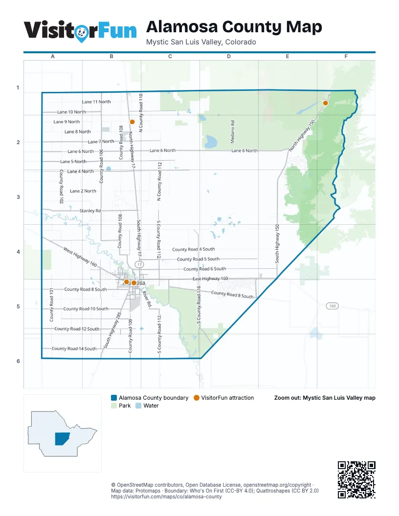
Street index of Alamosa County
Each street on the sheet and the grid squares it crosses.
- East Highway 160C4, D4, E4, C5
- North Highway 17B1, B2, B3
- West Highway 160A4, B4
- South Highway 285B5, B6
- South Highway 17B3, B4, B5
- Main StreetB1, B2, B4, B5
- Sixth StreetB5
- West AvenueB5
- Denver AvenueB5
- Santa Fe AvenueB5, C5
- Broadway AvenueB5
- East U.S. Highway 160A4
- Lane 6 NorthA2, B2, C2, D2, E2
- Lane 7 NorthA2, B2, C2
- North Highway 150F1, E2, F2, E3
- Stanley RoadA3, B3
- County Road 10 SouthA5, B5
- County Road 14 SouthA6, B6
- South County Road 6 East / South County Road 100A3, A4, A5
- North County Road 6 East / North County Road 100A1, A2, A3
- South Highway 150E3, E4
- North County Road 124F1
- County Road 12 / South County Road 100A5, A6
- North County Road 128.5F1
- Loop 3F1
- East County Road 10 SouthA5
- County Road 8 SouthA5, B5, C5, D5, E5
- County Road 6 SouthB4, C4, D4, E4
- Lane 4 NorthA3, B3, C3
- Lane 5 NorthA2, B2, C2
- South County Road 116C4, C5, D5, C6
- South County Road 106B3, B4, B5, B6
- North County Road 106B1, B2, B3
- County Road 5 SouthB4, C4, D4
- South County Road 112.C3, C4, C5, C6
- Lane 10 NorthA1, B1, C1
- County Road 12 SouthA5, B5
- South County Road 109B4, B5, B6
- County Road 11 SouthA5, B5
- County Road 3 SouthA4, B4
- South County Road 108B3, B4, B5, B6
- South River RoadB5, C5
- North River RoadB4
- El Rancho LaneC5
- Southeast County Road 116C5, D5, D6
- State AvenueB4, B5
- South County Road 122D4, D5
- Craft DriveB4, B5
- First StreetB5
- South County Road 112 / Harmony RoadC4, C5
- Ross AvenueB5
- Clark StreetB4
- South County Road 110 / Old Airport RoadB5
- West Tenth StreetB5
- West Eighth StreetB5
- Carroll StreetB4
- Tenth StreetB5
- County Road 4.5 SouthB4
- Twentieth StreetB5
- County Road 9 South / Airport RoadB5
- Tremont StreetB5
- Curtis LaneB4, C4
- Third StreetB5
- West Seventh StreetB5
- Fourth StreetB5
- Twelfth StreetB5
- Murphy DriveB4, B5
- Riverwood DriveB4
- Lakewood DriveB4
- La Due AvenueB5
- Stadium DriveB4
- Del Sol DriveB4
- Dunes RoadF1
- Maroon DriveB4
- White Pine DriveC4, C5
- Lane 5 North / 1st AvenueB2
- Seventeenth StreetB5
- Victoria StreetB4, B5
- Stockton RoadB5
- Weber DriveB4
- Washington AvenueB5
- Richardson AvenueB5
- Monterey AvenueB4, B5
- Twenty First StreetB5
- 17th StreetB5
- Edgemont BoulevardB5
- Pike AvenueB5
- East County Road 6 NorthA2
- De Sol DriveB4
- East County Road 4 NorthA3
- East County Road 3 NorthA3
- East County Road 12 South / County Road FFA5
- East County Road 8 SouthA5
- County Road 4 SouthB4, C4, D4, E4
- County Road 2 SouthA4, B4, C4, D4, E4
- North County Road 110B1, B2, B3
- North County Road 102A1, A2, A3
- Lane 8 NorthA2, B2, C2
- Lane 11 NorthA1, B1, C1
- North County Road 108B1, B2, B3
- North County Road 104A1, A2, A3
- Lane 9 NorthA2, B2, C2
- Lane 2 NorthA3, B3, C3
- South County Road 101A3, A4, A5, A6
- South County Road 104A4, A5, A6
- South County Road 103A4, A5, A6
- North County Road 112C2, C3
- South County Road 105B4, B5, B6
- South County Road 102A4, A5, A6
- County Road 9 SouthA5, B5
- Lane 1 NorthA3, B3, C3
- North County Road 109B1, B2, B3
- North County Road 111C1, C2, C3
- North County Road 105B1, B2, B3
- Medano RoadD1, D2
- North County Road 113C2, C3
- Blanca Wetlands RoadD3, D4
- Lake of the Falls ParkwayE2, E3
- Zapata Falls RoadE3
- Mill Run RoadE2
- County Road 1 SouthB3
- Cedar Ridge RoadE2, E3
- Valley Vista BoulevardD4, D5
- Road South 114C4, C5
- Road South 13.7C6
- County Road 7 SouthA5, B5
- County Road 15 South / County Road CCA6, B6, C6
- South County Road 110.B3, B4, C4
- South County Road 107B4, B5
- County Road A / Lane 12 NorthC1
- Lake View BoulevardD5
- Medano LaneC1, E2
- Cool Sunshine CircleB5
- North County Road 107B1, B2
- Urraca RoadE3
- North Honker RoadD3
- Lane 3 NorthA3
- North County Road 101A2
- South County Road 111C4
- South County Road 115C4
- Diorite DriveB3
- Mountain View BoulevardD5
- Agate LaneB3
- Hickory AvenueD5
- Foothill BoulevardD4, D5
- Mountian View BoulevardD5
- San Juan AvenueB5
- Estrella RoadB6
- Edison AvenueB5
- Eagle RoadB3
- Deer Run BoulevardD5
- Aspen AvenueB4, D5
- Sunrise BoulevardD4, D5
- Emperius RoadC5
- Cramer RoadB4
- Meadowlake BoulevardD5
- Vista DriveD5
- Frontage RoadB5
- County Road 5.75 South / Griego RoadB4
- North County Road 103A2
- Zapata Campground RV Loop RoadE3
- County Road 13 SouthA6
- Pyrite CircleB2
- South County Road 106.25B4, B5
- Malouff RoadB4
- Sierra Vista RoadB4
- County Road 0.73 SouthE3
- Deer Run LaneE2, D5
- North County Road 108.5B1
- Basalt DriveB3
- Lane 5.5 NorthB2
- Hampton Run RoadE2
- Otter DriveD5
- Antelope AvenueD5
- 2nd AvenueB1, B2
- Eleventh StreetB5
- County Road 7.4 SouthC5
- Big Bear RoadE2
- Pescos DriveE2
- Chamisa TrailC4
- Bell AvenueB5
- Star Sapphire AvenueD5
- Johnson RoadB3, C5
- Oxbow LoopB4
- Lava LaneB5
- Newsome RoadC5
- South County Road 106.5B4, B5
- Pleasant DriveD5
- Indian Hill RoadE2
- Ninth StreetB5
- Calcite LaneB3
- Pearl DriveD5
- Hunt AvenueB5
- Turquoise DriveD5
- Alamosa AvenueB5
- Eighth StreetB5
- Second StreetB5
- 3rd AvenueB1, B2
- Diamond AvenueD5
- Cottonwood DriveB4
- Palomino AvenueD5
- Gaumer LaneC4, C5
- Pinyon CircleF1
- Del Viento DriveB4
- Badger AvenueD5
- 4th AvenueB1, B2
- Van Iwaarden DriveB5
- California CircleE2
- Muskrat DriveD5
- A LoopD2
- Parrot DriveD5
- Arrastre RoadE2, E3
- Gold DriveD5
- Quartz DriveD5
- Medano Pass Primitive RoadF1
- Little Bear RoadE2
- Henry LaneB5
- Zircon DriveD5
- Aquamarine DriveD5
- No Name LaneC5
- Peridot DriveD5
- Maddux LaneB4
- Thirteenth StreetB5
- West Sixth StreetB5
- Garnet DriveD5
- Hart StreetB4
- Fourteenth StreetB5
- Cottonwood LaneC4, C5
- Trinchera LaneC4, C5
- Blanca Vista LaneC4, C5
- Barker StreetB2
- Loop 2F1
- Seventh StreetB5
- Rodeo LaneC5
- South County Road 112.8C4
- Cottonwood LoopE2
- Sarah LaneB4
- South County Road 106.75B4, B5
- School Desk RoadB1
- South County Road 112.9C4
- Twin Arrows LaneB4
- Agate CourtB3, D5
- Navajo RoadE2, B4
- Cottonwood CircleB4
- Foster AvenueB5
- Jade DriveD5
- Basalt WayB3
- South County Road 112.6C4
- Adams LaneC5
- Emerald DriveD5
- County Road 0.43 SouthE3
- Price AvenueB4, C4, B5, C5
- Forest DriveD5
- Basalt LaneB3
- Thomas AvenueB4
- Loop 1F1
- Skyway DriveD5
- Suburban AvenueD5
- Urraca DriveE2, E3
- 2nd StreetB5
- Railroad AvenueB5
- South County Road 110.5C4
- Topaz DriveD5
- Chico StreetB5
- C LoopD2
- South County Road 112.5C4
- Costilla AvenueB5, C5
- Oak DriveD5
- Bonney DriveB4, C4
- La Veta AvenueB4, B5
- Agate DriveD5
- Ridge DriveD5
- Vigil WayB4
- Apache Tear DriveD5
- Moonstone DriveD5
- Agate WayB3
- Douglas DriveB4
- McKinney AvenueB4, C4
- Marble DriveD5
- Redwing LaneC4, C5
- Commerce CircleB5
- Tinkham AvenueB4, C4
- Rio Grande AvenueB4, B5, C5
- Mourning Dove LaneC3
- Rustic DriveD5
- Basalt PlaceB3
- Brush LaneC5
- Ash DriveD5
- Market StreetB4
- Wild Acres LaneC5
- Quail DriveD5
- Echo DriveD5
- Galena DriveD5
- East AvenueB5
- Duke DriveB4
- South County Road 106.65B4
- Henry StreetB2
- West Lakewood DriveB4
- Ellsworth StreetC5
- Berkeley AvenueB4
Things to do on the Alamosa County map
Places on the map
- "The Wilderness"
- A Loop
- Abandoned
- Adams Lake
- Adams State University
- Alamosa
- Alamosa City Hall
- Alamosa Elementary
- Alamosa Family Recreation Center
- Alamosa High School
- Alamosa National Wildlife Refuge
- Alamosa Public Library
- Alamosa Riparian Park
- Bachelor Lake
- California Peak
- Carroll Park
- Cole Park
- Cotton Lake
- Crater Lake
- Dollar Lake
- Ellingwood Point
- Great Sand Dunes Oasis
- Green Acres Airport
- Head Lake
- High Dune
- Hooper
- Lake Como
- Las Arenas Earth and Sky Observatory Airport
- Little Bear Peak
- Loop 1
- Loop 2
- Main Copy Source
- Mosca Campground
- Oasis Campground
- Ortega Middle School
- Pinyon Flats Campground
- San Luis Lake
- San Luis Lake SWA
- Zapata Campground RV Loop Road
- Zapata Falls Campground
© OpenStreetMap contributors, Open Database License, openstreetmap.org/copyright · Map data: Protomaps · Boundary: Who's On First (CC-BY 4.0); Quattroshapes (CC BY 2.0)















