

Colorado map
Moffat County map
About 13,142 people live here (Census Bureau, 2024 estimate). The sheet's index lists 300 streets; County Road 7, County Road 17 and County Road 4 cross the most grid squares. Things to do inside the boundary: Dinosaur National Monument.
Open the map (PDF, US Letter)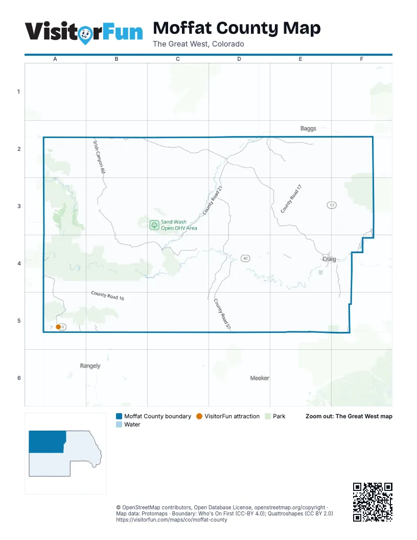
Street index of Moffat County
Each street on the sheet and the grid squares it crosses.
- West Victory WayD4, E4
- East Victory WayE4, F4
- Yampa AvenueE4
- Lincoln StreetE4
- Pershing StreetE4
- Brontosaurus BoulevardA5
- West 4th StreetE4
- Stegosaurus FreewayA5
- East 4th StreetE4, F4
- North Yampa AvenueE4
- Dinosaur Diamond Prehistoric HighwayA5
- County Road 7D2, D3, E3, E4, D5
- County Road 183E4
- County Road 4B2, C2, D2, E2
- County Road 10B3, B4, C4
- County Road 21D2, C3, D3, C4
- Harpers Corner RoadA4, A5
- County Road 57D4, D5
- Irish Canyon RoadB2, B3
- County Road 19D3, D4
- County Road 59D4, C5, D5
- County Road 29F3, F4
- County Road 86D2, E2, F4
- County Road 33F4, F5
- Conger Mesa RoadE2
- County Road 36F3, F4
- County Road 65F4, F5
- County Road 61B5
- Ranney StreetE4
- County Road 134A5
- South Ranney StreetE4
- West 1st StreetE4
- West 9th StreetE4
- Stock DriveE4, F4
- East 1st StreetE4, F4
- Mack LaneE4
- Finley LaneE4
- County Road 36AF3
- Lowell StreetD4
- Hiawatha RoadB2
- West 10th StreetE4
- Ellis AvenueD4
- 1st StreetF4
- County Road 17E2, E3, D4, E4, E5
- County Road 67C2, C3
- County Road 16A5, B5
- County Road 3E2, E3, E4
- County Road 23C4, D4, C5, D5
- Mantle Ranch RoadA4, B4
- County Road 32D4, D5, E5
- Black Mountain RoadF3
- County Road 72A2, B2
- County Road 2E2, F2
- County Road 8D3, E3
- County Road 4WB2, C2
- Douglas Mountain BoulevardA4, B4
- Bear Valley RoadB4, B5, C5
- County Road 53D4, D5, E5
- County Road 50D3
- Dinosaur Park Service RoadB4, C4
- County Road 6D3, E3
- County Road 9E2, E3
- County Road 5E3
- County Road 101E2
- County Road 103F3, F4
- County Road 42D2, D3
- County Road 95B4, B5
- County Road 126C2, C3
- County Road 88D2, E2
- County Road 52B3, C3
- County Road 46B3
- Slater Creek RoadF2
- County Road 41E5
- Freeman Reservoir RoadF3
- County Road 18F3
- County Road 30E4
- County Road 91D2
- County Road 15E4, E5
- County Road 34A3, B3
- County Road 45E5
- County Road 48B3, C3
- County Road 51D5, E5
- County Road 22E3, E4, F4
- Echo Park RoadA4
- County Road 21ND2
- County Road 85C4
- County Road 55D4, D5
- County Road 25C4
- County Road 63B2
- County Road 93E4, D5, E5
- County Road 37E5, F5
- County Road 44D3
- County Road 150D3
- Yampa Bench RoadA4
- County Road 138B3
- County Road 143C4, D4
- County Road 38F2, E3, F3
- County Road 74D4
- County Road 83A2, A3
- County Road 104B5
- County Road 70E2, F2
- County Road 109E3
- County Road 64E4
- County Road 110E2, E3
- County Road 106E3
- County Road 4SB2
- County Road 20F4
- County Road 31E4
- County Road 18NF3
- Deer Valley RoadB4, B5, C5
- County Road 56B3
- County Road 133D4, E4, D5
- County Road 69D3
- County Road 12B3
- County Road 107E4
- Lower Bear Valley RoadB4, B5
- County Road 164A3
- County Road 43E5
- County Road 47E4, E5
- County Road 21SC4
- County Road 153C4
- County Road 157B4, B5
- County Road 68C2
- Grackle RoadF2, F3
- Miller Creek RoadB5
- Timberlane DriveF2
- County Road 80B3, C3
- County Road 105E4
- County Road 131D3
- County Road 90E4
- County Road 99D3
- Miners Draw RoadA5
- County Road 56SB3, B4
- County Road 77D4
- County Road 146E2
- West Prong RoadF3
- County Road 78F4, B5
- Routt Forest DriveF2
- County Road 13F3, F4
- County Road 70 NorthF2
- County Road 14B4, B5, C5
- Sprout DriveF2
- County Road 63FB2
- County Road 161A5
- County Road 39E5
- Boulder DriveF2
- County Road 174E4
- County Road 147D2
- County Road 54F3
- County Road 68NC2
- County Road 24E4
- County Road 53ND4
- County Road 89E3, F3
- County Road 129F2
- Box Canyon RoadE4
- County Road 62C2
- County Road 49E5
- Timberlane LoopF2
- Second Creek RoadF2
- County Road 204E4
- County Road 124F2
- Blue Mountain RoadA4
- County Road 35E4, F4
- County Road 28F4
- County Road 18 SouthF3, F4
- Rocky Mountain WayF2
- County Road 2NE2
- County Road 179F4, F5
- Fiddleneck DriveF2
- County Road 59SD4
- County Road 68EC2
- County Road 144E2
- County Road 4NE2
- West Sand Point RoadF2, F3
- Dunn RoadF3
- County Road 34NA3
- County Road 9NE2
- County Road 113F4
- Game Reserve DriveF2
- Eagle LoopF2
- Sand Point RoadF3
- County Road 4BB2
- County Road 95CB5
- Barclay StreetE4
- County Road 117E2, E3
- County Road 14BC5
- County Road 98B3
- County Road 112F4
- Valley View DriveE4
- County Road 178F4
- County Road 82F2, E4
- County Road 175D4
- County Road 166A2, A3
- County Road 64WE4
- Blue Mountain AvenueA5
- County Road 203E4
- Lynch Spring RoadF3
- Hitchens DriveF2, F3
- County Road 119B4
- Creek 139E4
- County Road 180E5
- County Road 120F4
- Little Bear RoadF3
- County Road 14CC5
- Sage Brush CourtE4
- County Road 9WE2
- County Road 26C3, D3
- County Road 63GB2
- County Road 200E4
- Johnson RoadF4
- Rose StreetE4
- School StreetE4, A5
- Johnson WayF4
- Dipper DriveF2
- Routt Forest LoopF2
- Co Road 81E4
- County Road 84B4
- Washington StreetE4
- Handyman RoadF3
- County Road 184F4
- West 6th StreetE4
- Forest Service RoadF2
- East 9th StreetE4, F4
- Roberts RoadE4
- East 7th StreetE4, F4
- West 3rd StreetE4
- Colorado StreetE4
- Crescent DriveE4
- County Road 160D3
- County Road 63IB2
- Breeze StreetE4
- County Road 81E4
- Treemoss DriveF2
- Eagle DriveF2
- Western AvenueE4
- County Road 209E4
- East Johnson Loop / Dunn DriveE4
- Legion StreetE4
- Taylor StreetE4
- Hospital LoopE4
- East 13th StreetE4, F4
- Highland DriveF4
- Knoll AvenueE4
- Granite RoadF2
- County Road 210F4
- County Road 221E4, F4
- Falcon DriveF2
- County Road 165B5
- Sequoia AvenueE4
- County Road 132D2
- County Road 114A3
- Coal Mine RoadE4
- Ashley RoadF4
- East 10th StreetE4, F4
- Falcon BypassF2
- 3rd StreetA5
- County Road 31 EastE4
- County Road 205E4, F4
- County Road 173E4
- Sand Glutch RoadF4
- Tucker StreetE4
- Russell StreetE4
- Lay Creek DriveD4
- Green StreetE4
- Eastview DriveF2
- Thornburg DriveD4
- County Road 63HB2
- Sycamore RoadF2
- Aspen AvenueE4
- Little Willow RoadF2
- 2nd StreetA5
- East 11th StreetE4, F4
- Doe Run DriveE4
- Sunset DriveE4
- Ledford StreetE4
- Haughey RoadF4
- Canyon Road 7bE4
- Steele StreetE4
- Doyan AvenueE4
- West 8th StreetE4
- Circle DriveE4
- Woodbury DriveE4
- County Road 4AB2
- Exmoor RoadE4
- Triceratops TerraceA5
- Camptosaurus CrescentA5
- Antrodemus AlleyA5
- East 8th StreetE4, F4
- County Road 121F2
- Bryan WayF4
- 5th StreetA5
- Hill DriveE4
- Freeman Reservoir Campground RoadF3
- County Road 170B3
- County Road 201E4
- Pine Ridge DriveE4
- 4th StreetA5
- Stout StreetE4
- Industrial AvenueE4
- Spring Coulee WayE4
Things to do on the Moffat County map
Places on the map
- Allred Peak
- America/Denver Timezone
- Ant Hills Wilderness Study Area
- Bakers Peak
- Bald Mountain
- Basset Reservoir Number 2
- Bears Ears Campground
- Bible Back Mountain
- Bighole Butte
- Bill Weller Mesa
- Bishop Peak
- Browns Park National Wildlife Refuge
- Bull Canyon Wilderness Study Area
- Colowyo Strip Mine
- Craig
- Craig-Moffat Airport
- Cross Mountain Wilderness Study Area
- Culverwell Reservoir
- Diamond Breaks Wilderness Study Area
- Dinosaur
- Dinosaur National Monument
- Dresher Reservoir
- Elk Head Reservoir
- Freeman Reservoir
- Loudy-Simpson Recreation Area
- Lower Cogdill Lake
- Martin Cull Reservoir
- Miles Reservoir
- Moffat County Fair Grounds
- OVO Reservoir
- Peterson Draw Wilderness Study Area
- Pronghorn Campground
- Sand Wash Open OHV Area
- Skull Creek Wilderness Study Area
- Steamboat Rock
- Vale of Tears Wilderness Study Area
- West Cold Springs Wilderness Study Area
- Willow Creek Wilderness Study Area
- Wilson Reservoir
- Yampa Valley Golf Club
Next to Moffat County
- Baggs
- Meeker
- Rangely
© OpenStreetMap contributors, Open Database License, openstreetmap.org/copyright · Map data: Protomaps · Boundary: Who's On First (CC-BY 4.0); Quattroshapes (CC BY 2.0)















