

Colorado map
Summit County map
About 30,882 people live here (Census Bureau, 2024 estimate). The sheet's index lists 300 streets; Heeney Road, Rodeo Drive and Main Street cross the most grid squares. Things to do inside the boundary: Breckenridge Ski Resort and Performance Tours Rafting.
Open the map (PDF, US Letter)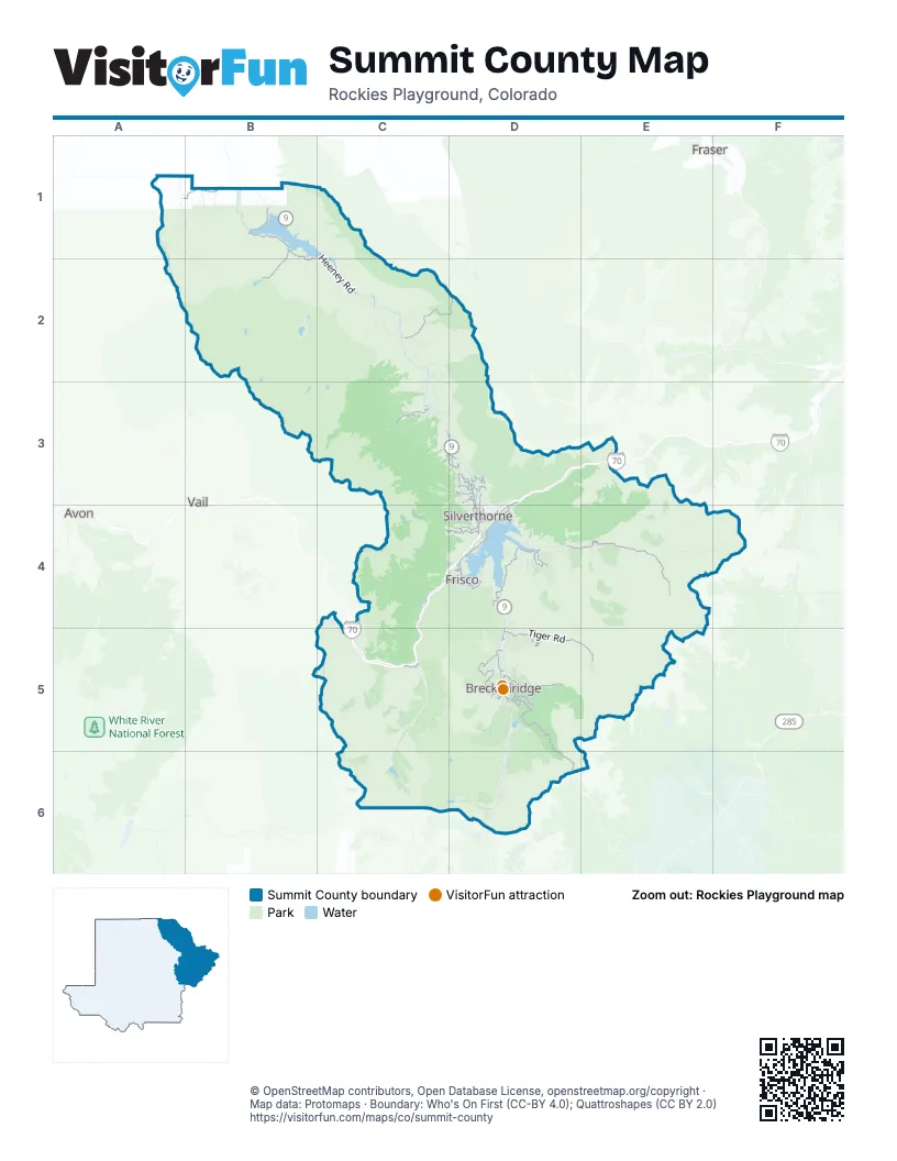
Street index of Summit County
Each street on the sheet and the grid squares it crosses.
- Gerald R. Ford Memorial HighwayC5
- Eisenhower Memorial TunnelE3
- Edwin C. Johnson Memorial TunnelE3
- Montezuma RoadE4
- Blue River ParkwayD3, D4
- Summit BoulevardD4
- Main StreetD4, E4, D5
- North Park AvenueD5
- South Main StreetD5
- East Main StreetD4
- West Main StreetC4, D4
- South Park AvenueD5
- Swan Mountain RoadD4
- Dillon Dam RoadD4
- North Main StreetD5
- Heeney RoadB1, C1, B2, C2
- Boreas Pass RoadD5, D6
- Tiger RoadD5, E5
- Ute Pass RoadC2, D2
- Ski Hill RoadD5
- Ryan Gulch RoadC4, D4
- County Road 10A1, B1
- Rock Creek RoadC3
- Golden Eagle RoadD3
- French Gulch RoadD5
- Cataract Lake RoadB1, B2
- Estates DriveD5
- Hamilton Creek RoadD3
- Copper RoadC5
- Maryland Creek RoadC3, D3
- Barton RoadD5
- Rainbow DriveD3, D4
- Bald Eagle RoadD3
- Airport RoadD5
- Royal Buffalo DriveD4
- Cove BoulevardD4
- Adams AvenueD3, D4
- Alpensee DriveD4
- Straight Creek DriveD3, D4
- Mount Baldy RoadD5
- Willowbrook RoadD3
- Summit DriveD3, D4
- West Keystone RoadD4, E4
- Wellington RoadD5
- Ptarmigan TrailD4
- High Point DriveD5
- Deer Path RoadD4
- Kestrel LaneD3
- Four O'Clock RoadD5
- Wildernest RoadD4
- La Bonte StreetD4
- Tanglewood LaneD4
- Meadow DriveD4
- Brian AvenueD4
- Recreation WayD4
- Ruby Ranch RoadD3
- Peak One BoulevardD4
- Moonstone RoadD5
- Tenderfoot StreetD4
- Reiling RoadD5
- Little Beaver TrailD4
- Peak One DriveD4
- Lake Dillon DriveD4
- Royal Tiger RoadD5
- Hawn DriveD4
- Stan Miller DriveD5
- 4th StreetD4, E4
- East Keystone RoadE4
- Game Trail RoadD3
- Coyne Valley RoadD5
- North French StreetD5
- Buffalo StreetD4
- Stephens WayD4
- Smith Ranch RoadD3
- Kings Crown RoadD5
- Buffalo Mountain DriveD4
- Village RoadD5
- Huron RoadD5
- Maryland Creek LaneD3
- Gondola RoadE4
- Shores LaneD4, D5
- Allegra LaneD3
- Center CircleD4
- Evergreen RoadD4
- 6th StreetD4
- Lagoon LaneD4
- Buffalo DriveD4
- Annie RoadD4
- Short Cut RoadD5
- Twenty Grand DriveD4
- Lusher CourtD4
- Valley Brook StreetD5
- Rancher's RoadD3
- McCain DriveD5
- Jarelle DriveD4
- West Keystone Road / Tennis Club RoadD4
- Lower Spring Creek RoadA1, B1, B2
- Elliot Ridge RoadA1, A2
- Peru Creek RoadE4, F4
- Black Creek RoadB1, B2, C2
- Keystone Gulch RoadD4, E4
- Highlands DriveD5
- Rodeo DriveC2, C3, D3, D5
- Williams Peak RoadB1, C1
- Keystone Ranch RoadD4
- Johnson RoadC2, C3
- Upper Mesa TrailB1
- Mc Cullough Gulch RoadD6
- Blue Ridge RoadC2, C3, D5
- Shrine Pass RoadC4, C5
- Spruce Creek RoadD5, D6
- Indiana Creek RoadD5
- Miller Gulch RoadC2
- Elk Run RoadC2
- Pass Creek RoadC2
- Meadowbrook LaneC3
- Tyl Ranch RoadD3
- Dice Hill RoadA1
- Pioneer Creek RoadC3, D3
- Cow Creek South Campground RoadB1
- Fausel Conservancy RoadC3
- Slate Creek RoadC2
- Miners Creek RoadD4
- Mount Powell LaneC2
- Mount Powell RoadC2
- Triple Creek Ranch RoadC3
- Blue Lakes RoadD6
- Spring Creek Ranch RoadB1
- Gold Run Gulch RoadD5
- Jones Gulch RoadE4
- American WayD5
- Soda Ridge RoadD4
- Revett DriveD4, D5
- Broken Lance DriveD5
- Windy Point Campground RoadD4
- Darby DriveC2
- Silver CircleD5
- Forest Hills DriveD5
- Discovery Hill DriveD5
- Emerald RoadD3
- Lindstrom RoadC2
- Otter Creek RoadB2
- Copper ShuttleC5
- Harrigan Creek RoadC2
- Fairview BoulevardD5
- Roberts Tunnel Access RoadD4
- Sage Creek Canyon DriveD3
- Lakeview CircleD3
- Beeler PlaceC5
- Old Highway 9C2
- Penstemon RoadD4
- Cumberland DriveD5
- Straight Creek TrailD3, D4
- Braddock DriveD5
- Landfill RoadD4
- Spruce Valley DriveD5
- Whispering Pine CircleD6
- Palmers DriveD3, D4
- Cowboy TrailB1
- Preston WayD5
- Pebble Creek RoadC3
- Muggins Gulch RoadD4, D5
- Royal Coachman BoulevardD4
- Lowry Campground RoadD4
- Rounds RoadD5
- Independence RoadE4
- Highfield TrailD4, D5
- Climax Mine RoadC6
- Pine Cove Campground RoadD4
- Garnet RoadD3, D4
- Piney Acres CircleD4
- Gold King WayD5
- Long RoadC2
- Range RoadD6
- Parkville RoadE5
- Ruby RoadD3, D4
- Idlewild DriveD4
- Blue River RoadD5, D6
- Hillside DriveD3
- County Road 22C6
- Shekel LaneD5
- Heaton Bay Campground RoadD4
- Flanigan RoadB1
- Two Cabins DriveD3
- High Meadow DriveD4
- Fly Line DriveD3
- Ptarmigan Ranch RoadD3, D4
- G RoadD3, D4
- Blue Lake RoadD6
- Kimmes LaneD6
- White Cloud DriveD5
- Whispering Pines Ranch RoadD4
- Western Sky DriveD5
- Alpine RoadD4
- Whatley Ranch RoadD5
- Willows Campground RoadB1
- Falcon DriveD3
- Antler RoadD3
- Vail CircleD4
- Doris DriveD6
- Ute Park RoadC2
- Illinois Gulch RoadD5
- Fairways DriveD5
- Bear Wallow RoadC3
- Midas Meadow DriveD3
- Rio Azul RoadD6
- Tordal WayD6
- Elk CircleD4
- Antlers Gulch RoadD4
- Camron LaneD6
- Officers Gulch RoadC4
- Wrangler TrailB1
- Creekside DriveD4
- Miners View RoadD5
- Coronet DriveD5, D6
- Tennis Club RoadD4
- Glen Eagle LoopD5
- Alpensee RoadD4
- North Fuller Placer RoadD5
- South 7th AvenueD4
- Lake View DriveB1, D4
- P RoadD4
- 97 CircleD6
- Benson LaneC2
- Gateway DriveD4
- South French StreetD5
- Hamilton LaneD6
- Peerless DriveD5
- Carroll LaneD6
- Mount Argentine RoadD5
- Riata TrailB1
- Shock Hill DriveD5
- Haystack Mountain RoadB1
- Grandview DriveD5
- Rena RoadD6
- Temple TrailD4
- Elliott Creek Campground RoadB1
- Currant WayD3
- Westerman RoadD5
- Blue Flag CircleD5
- Meadow Creek TrailD4
- Lakeview Circle EastD4
- Granite StreetD4
- Cartier CourtD4
- Corkscrew DriveD5
- Arnica LaneD3
- Pitkin StreetD4
- Hunter's Knob RoadD3
- Mountain View DriveD5, D6
- Footfalls RoadD4, D5
- Crown DriveD5
- J RoadD4
- Lakeview DriveD5
- Royal Red Bird DriveD4
- Golden Age DriveD5
- Elk View RoadC2
- Lake Uneva RoadC4
- Water Dance DriveD4
- Bridge StreetD5
- Lakeview Circle WestD4
- Gold Hill RoadD4
- Louis DriveD5
- Alpine DriveC4, D4
- Marksberry WayD5
- Prairie Point Campground RoadC2
- Cow Creek North Campground RoadB1
- Wilderness DrivdD5, D6
- Highwood TerraceC4, D4
- Dyer tTailD5
- North Gold Flake TerraceD5
- Quandary RoadD6
- Ensign DriveD4
- D RoadD4
- Juniata CircleD5
- Summerwood DriveD4
- Latigo TrailB1
- Peak One Campground RoadD4
- Hummingbird CircleD4
- Fish Creek RoadC3, D3
- Silver Queen DriveD5
- Sherwood TrailD4
- Frisco StreetD4
- Wild Irishman RoadD4
- Slalom DriveD5
- Wagon RoadD5
- Teller StreetD4
- Decatur Hill RoadD4
- Aspen DriveC4, D4
- South 5th AvenueD4
- Peak One Campground Spur RoadD4
- Sunburst LaneD5
- Lake Edge DriveD5
- Granite AlleyD4
- Windflower LaneD4
- Meadow Wood CircleD4
- Timber Trail RoadD5
- Elk Crossing LaneD4
- South Ridge StreetD5
- 3rd StreetD4, E4
- Cucumber RoadD5
Things to do on the Summit County map
Places on the map
- Arapahoe Basin
- Black Creek Reservoir
- Black Lake
- Blue Lakes
- Blue River
- Boulder Lake
- Breckenridge
- Breckenridge Golf Club Bear 9
- Breckenridge Golf Club Beaver 9
- Breckenridge Golf Club Elk 9
- Breckenridge Recreation Ground
- Bubble Lake
- Camp Hale - Continental Divide National Monument
- Clinton Gulch Reservoir
- Copper Mountain
- Cucumber Gulch Preserve
- Dillon
- Dillon Reservoir
- Dillon Ridge Shopping Center
- Eagles Nest Wilderness
- Frisco
- Frisco Adventure Park
- Goose Pasture
- Goose Pasture Tarn
- Green Mountain Reservoir
- Heaton Bay
- Hoagland Reservoir Number 1
- Keystone
- Keystone Ranch Course
- Keystone River Course
- Lower Blue Reservoir
- Lower Cataract Lake
- Lower Enchanted Forest
- Peak One Disc Golf Course
- Ptarmigan Peak Wilderness
- Silverthorne
- Uneva Lake
- Upper Slate Lake
Next to Summit County
- Avon
- Fraser
- Vail
© OpenStreetMap contributors, Open Database License, openstreetmap.org/copyright · Map data: Protomaps · Boundary: Who's On First (CC-BY 4.0); Quattroshapes (CC BY 2.0)















