

Connecticut map
Hartford map
About 122,129 people live here (Census Bureau, 2024 estimate). The sheet's index lists 300 streets; Main Street, Albany Avenue and Maple Avenue cross the most grid squares. Things to do inside the boundary: Connecticut Museum of Culture and History, Connecticut Science Center and Pope Park.
Open the map (PDF, US Letter)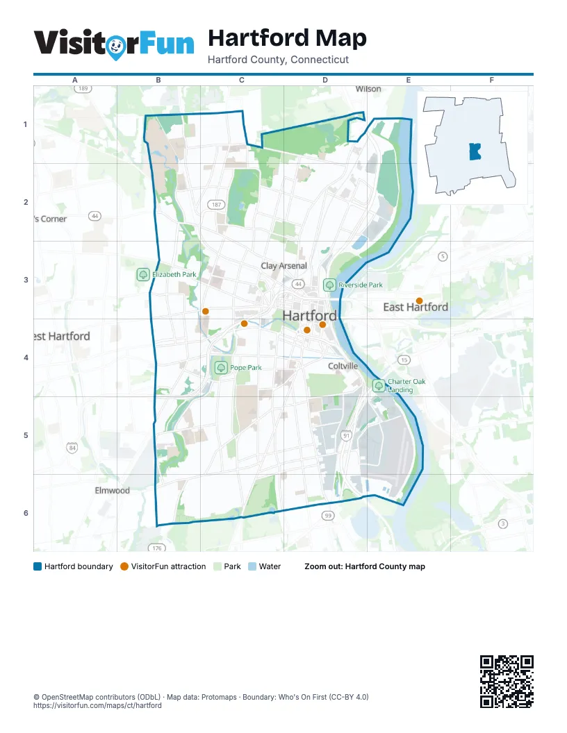
Street index of Hartford
Each street on the sheet and the grid squares it crosses.
- Main StreetD1, D2, D3, D4
- Albany AvenueB2, C2, C3, D3
- Wethersfield AvenueD4, D5, D6
- Farmington AvenueB3, C3
- Asylum AvenueB3, C3
- Trumbull StreetD3, D4
- Columbus BoulevardD3, D4
- Asylum StreetC3, D3
- Bloomfield AvenueB2
- Wyllys StreetD4
- Windsor AvenueD1
- Jewell StreetD3, D4
- South Morgan StreetD3
- Silas Deane HighwayD6
- Pulaski CircleD4
- North Morgan StreetD3
- Ford StreetC3, D3
- Meadow RoadD1
- Maple AvenueD4, C5, D5, C6
- Broad StreetC3, C4, C5
- Tower AvenueB1, C1, D1, D2
- Garden StreetD1, C2, D2, C3
- Park StreetB4, C4, D4
- Capitol AvenueB4, C4, D4
- New Britain AvenueC5, B6, C6
- Franklin AvenueD4, D5, D6
- Blue Hills AvenueC1, C2
- Windsor StreetD2, D3
- Weston StreetE1, D2
- Granby StreetB1, B2, C2
- Sigourney StreetC3, C4
- Fairfield AvenueC5, C6
- Woodland StreetC2, C3
- Scarborough StreetB2, B3
- Zion StreetC4, C5
- Prospect AvenueB3, B4, B5
- Homestead AvenueB2, C2, C3
- Washington StreetC4, C5
- Westbourne ParkwayB2, C2
- Jennings RoadD2, E2
- New Park AvenueB4, B5
- Park TerraceC4
- Summit StreetC4, C5
- Brown StreetC5, D5
- White StreetC5, C6
- West BoulevardB4
- Sisson AvenueB3, B4
- Reverend Robert A. Moody OverpassD2, D3
- Whitney StreetB3
- South Whitney StreetB3, B4
- Brainard RoadD5, D6
- Newington AvenueB6
- Market StreetD3
- Retreat AvenueC4, D4
- Airport RoadD5
- Harvard StreetC6
- Pleasant StreetD3
- Boce Barlow WayD2
- Pearl StreetD3
- Webster StreetC5
- State StreetD3, D4
- Cogswell StreetC3
- American RowD3, D4
- Central RowD3
- Grove StreetD4
- Hartford AvenueB6, D6
- Hillside AvenueC4, C5, C6
- West Service RoadE1, D2, E2
- Brookfield StreetC4, B5, C5
- Cornwall StreetC1, B2, C2
- Vine StreetC2, C3
- Campfield AvenueC5, C6
- Flatbush AvenueB5, C5
- Mark Twain DriveB1, B2
- Holcomb StreetB2, C2
- Barbour StreetD1, D2
- South StreetC5, D5, C6
- Coventry StreetC1, C2
- Murphy RoadD5, E5
- Locust StreetD4, D5
- Ridgefield StreetC2
- Westland StreetC2, D2
- Wawarme AvenueD4, D5
- Plainfield StreetB2, C2
- Leibert RoadD2, E2
- Greenfield StreetC2
- Hamilton StreetB4, C4
- Newfield AvenueB5, B6
- Maxim RoadD5, E5
- Preston StreetC5, D5
- Jefferson StreetC4, D4
- Capen StreetC2, D2
- Collins StreetC3
- Reserve RoadD4, E4, E5
- Van Dyke AvenueD4
- Ann Uccello StreetD3, D4
- Sheldon StreetD4
- Hudson StreetD4
- Charter Oak AvenueD4
- Vernon StreetC4
- Walnut StreetC3, D3
- Church StreetC3, D3
- High StreetC3, D3
- Fishfry StreetD2, E2
- Meadow StreetD5
- West Preston StreetC5
- Fern StreetB3
- Elm StreetC4, D4
- Edwards StreetC3
- Buckingham StreetC4, D4
- Sherman StreetB3
- Shultas PlaceD5
- Chapel Street SouthD3
- Chapel Street NorthD3
- Burlington StreetB2, C2
- Charlotte StreetC2, D2
- Prospect StreetD4
- Myrtle StreetC3
- F. D. Oates AvenueC2, D2
- Kane StreetB4
- Fraser PlaceC3
- Talcott StreetD3
- Arch StreetD4
- Spring StreetC3
- Ridge RoadC6
- Spruce StreetC3
- Allyn StreetC3, D3
- Mahl AvenueD2
- Trinity StreetC4
- Barnard StreetC5
- South Prospect StreetD4
- Union PlaceC3
- Bob Steele StreetD4
- Taylor StreetD4
- Gold StreetD4
- Wells StreetD4
- Folly Brook BoulevardC6
- Asylum PlaceC3
- Ledyard StreetD5, D6
- Edgewood StreetC2, C3
- Lyme StreetB1, B2, C2
- Palm StreetC1, B2, C2
- Linnmoore StreetC5, B6, C6
- Broadview TerraceC5, B6
- Freeman StreetB6, C6
- Laurel StreetC3, C4
- Branford StreetB1, C1
- Grandview TerraceC5, C6
- Avery HeightsB6
- Oxford StreetB3, B4
- George StreetD5, D6
- Enfield StreetC2, C3
- Goodwin Park RoadC6
- Cleveland AvenueD1, D2
- Westerly TerraceB2
- Chandler StreetB5, C5, C6
- Victoria RoadC6, D6
- Mountain StreetB6, C6
- Kenyon StreetB3
- Roger StreetC5, C6
- Russ StreetC4
- Ashley StreetC3
- Mather StreetC3, D3
- Lindbergh DriveE5
- Girard AvenueB3
- Terry RoadB2, B3
- Colebrook StreetB2, C2
- Sargeant StreetC3
- Newbury StreetC5, C6
- Riverside Park RoadD2, D3
- Hawk DriveB1
- North Beacon StreetB3
- Burnham StreetB1, C1
- Pembroke StreetB2, C2
- Huyshope AvenueD4
- Bonner StreetB5, C5
- Ward StreetC4
- Manchester StreetB1, C1
- Adelaide StreetC5, D5
- Martin StreetC2, D2
- Thomaston StreetB2, C2
- University DriveB1, B2
- Westminster StreetB1, C1
- Beacon StreetB3, B4
- Hanmer StreetC6, D6
- Warrenton AvenueB4
- Magnolia StreetC2, C3
- Standish StreetC5, D5
- Andover StreetB2, C2
- Barker StreetC5, D5
- Lawrence StreetC4
- Hampton StreetD1, D2
- Putnam StreetC4
- Morningside Street WestB1, C1
- Euclid Street WestB1, C1
- Allen PlaceC4
- Sherbrooke AvenueB5, C5
- Nelson StreetC2, D2
- Hubbard RoadC6
- Benton StreetC5, D5
- Gilman StreetC5, D5
- Monroe StreetC5, C6
- Catherine StreetB5, C5
- Amherst StreetC6
- Bond StreetC5, D5
- Elliott Street EastD5
- Douglas StreetC5, D5
- Elizabeth StreetB3
- Bartholomew AvenueB4, C4
- Oakland TerraceC2, C3
- Otis StreetC5, D5
- Dart StreetB5, C5
- Harold StreetB1, C1
- Brook StreetC2, C3
- Clark StreetD2
- Adams StreetC2, C3
- Roosevelt StreetD5, D6
- Princeton StreetB6, C6
- Stonington StreetD4
- Bushnell StreetC5, D5
- Waverly StreetC1, C2
- Wilson StreetC5
- Woodside CircleB3
- Tremont StreetB3, B4
- Forest StreetC3, C4
- Hawthorn StreetC4
- Cromwell StreetC6, D6
- Kensington StreetD2
- Niles StreetC3
- Yale StreetC6
- Affleck StreetC4
- Francis AvenueB4
- Hartland StreetC1
- Goodwin CircleB3
- Salisbury StreetC1
- Kent StreetC2, C3
- Babcock StreetC4
- Saybrooke StreetB5, C5
- Montrose StreetB6
- Love LaneC2
- Earle StreetD2
- Theodore Napper LaneD2
- Huntington StreetC3
- Bellevue StreetD2
- Goodrich StreetC6, D6
- Grant StreetB6
- Hungerford StreetC4
- Stanwood StreetB6
- Chatham StreetB2, C2
- Seymour StreetC4
- Coolidge StreetB5, C5
- Oak StreetC4
- Roslyn StreetB6
- Wooster StreetD2, D3
- Montowese StreetC6, D6
- Chester StreetC6, D6
- Tredeau StreetC6, D6
- Canterbury StreetC2
- Atwood StreetC3
- Pope Park HighwayC4
- Ansonia StreetC5
- Forster StreetB6
- Irving StreetC3
- Mansfield StreetC2
- Madison StreetC4
- Baltimore StreetC2
- Evergreen AvenueB3, B4
- Hebron StreetB2, C2
- Nilan StreetB5, C5
- Lincoln StreetC4
- Cumberland StreetB6
- Lebanon StreetC1
- Arnold StreetC5
- Glendale AvenueC4
- Bates StreetC6
- Van Block AvenueD4
- Newton StreetB4
- Harbison AvenueC4
- Bannister StreetC5
- Park River DriveB2
- Roxbury StreetC5
- Rosemont StreetD1
- Sharon StreetB2, C2
- Lafayette StreetC4
- Mapleton StreetC5
- Aetna WayC3, C4
- Westbrook StreetB5
- Ellington StreetB5
- Grand StreetC4
- Henry StreetC5
- Ledger StreetC5
- Boothbay StreetC1
- East Burnham StreetC1
- Saint Monica's AvenueD1
- Gillett StreetC3
- Mountford StreetC5
- South Marshall StreetC3, C4
- Osten BoulevardD4
- Salem StreetC6
- Cowles StreetC6, D6
Things to do on the Hartford map
Places on the map
- Aetna
- Alfred E. Burr Middle School
- Ann Street Post Office
- Auerbach Art Library and Museum Archives
- Barbour Branch Library
- Barry Square Post Office
- Bulkeley High School
- Capitol Region Education Council
- Carmax
- Cemetery Pond No. 2
- Charter Oak Landing
- Charter Oak Marketplace
- Colt Armory
- Colt Park
- Columbus Park
- Connecticut Convention Center
- Connecticut State Capitol Park
- Connecticut State Library
- Constitution Plaza
- Dr. Michael D. Fox School
- Dwight Branch Hartford Public Library
- Fred D. Wish Museum School
- Gateway Plaza
- Global Communications Academy
- Goodwin Park
- Goodwin Park Golf Course
- Hartford Correctional Center
- Hartford Hospital
- Institute of Living
- Keney Park
- New Haven–Springfield Line
- Pope Park
- Riverside Park
- Rocky Ridge Park
- Spring Grove Cemetery
- The Hartford
- Trinity College
- U-Haul
- University of Hartford
- Xfinity Theatre
Next to Hartford
- Bishop's Corner
- East Hartford
- Elmwood
- West Hartford
- Wilson
© OpenStreetMap contributors, Open Database License, openstreetmap.org/copyright · Map data: Protomaps · Boundary: Who's On First (CC-BY 4.0); U.S. Census Bureau