

Connecticut map
New Britain map
About 75,871 people live here (Census Bureau, 2024 estimate). The sheet's index lists 300 streets; Stanley Street, Corbin Avenue and West Main Street cross the most grid squares. Things to do inside the boundary: New Britain Museum of American Art.
Open the map (PDF, US Letter)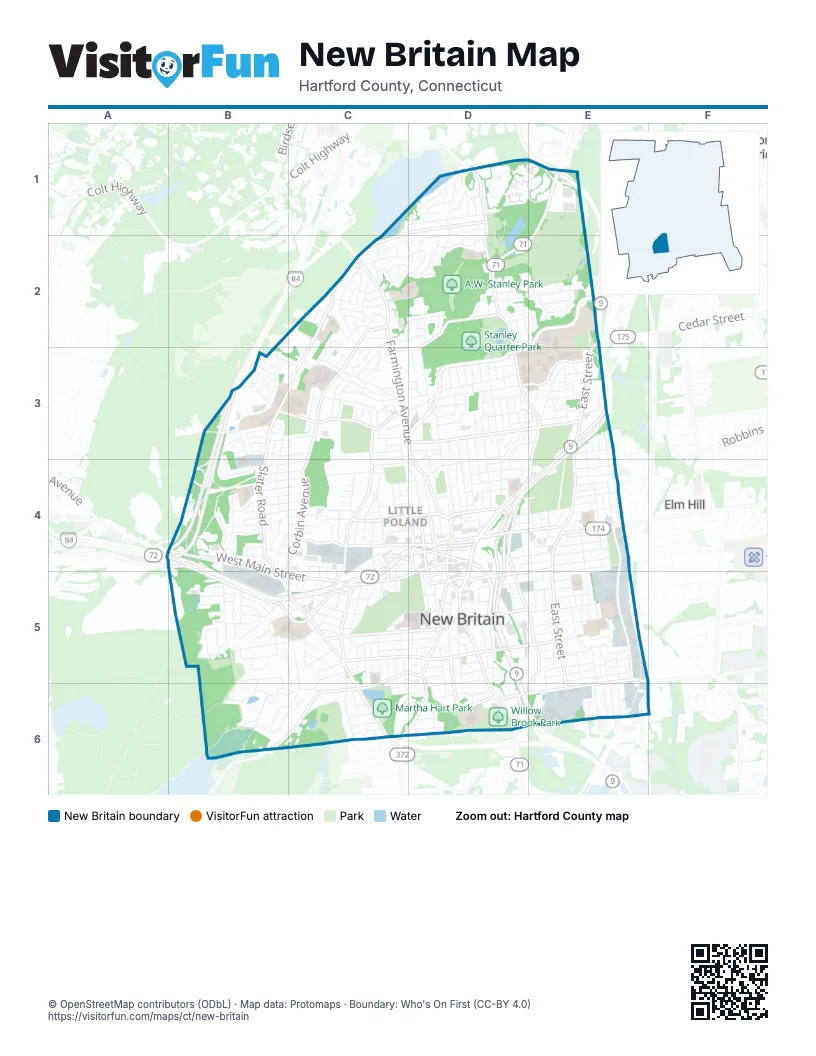
Street index of New Britain
Each street on the sheet and the grid squares it crosses.
- Corbin AvenueC2, C3, C4, B5, C5, C6
- West Main StreetB4, D4, B5, C5, D5
- East Main StreetD4, E4
- South Main StreetD5, D6
- Harry Truman OverpassD4, D5
- Franklin SquareD5
- Elm StreetD5
- New Britain AvenueB4, E4
- New Britain RoadD6
- Stanley StreetD1, D2, D3, E3, D4, E4, D5, E5, E6
- East StreetE2, E3, E4, E5, E6
- Slater RoadC2, B3, C3, B4
- Ella Grasso BoulevardE2, D3, E3
- Farmington AvenueC2, C3, D3, D4, C6
- Allen StreetD3, E3
- Hartford RoadE1, D2, E2
- South StreetE5, F5, D6, E6
- Broad StreetC4, D4
- Main StreetD4, D5
- Arch StreetD5
- Washington StreetD4
- Kensington AvenueD5, C6, D6
- Martin L. King DriveD4
- Beaver StreetD4
- Newington AvenueE4
- Christian LaneF5, E6
- Cedar StreetE2, D4, D5
- Norton RoadB4, B5
- Eddy Glover BoulevardC3, D3
- Columbus BoulevardC4, D4, D5
- Black Rock AvenueA4, B4, B5, C5
- Osgood AvenueB3, C3
- Shuttle Meadow AvenueC5, D5, B6, C6
- Lincoln StreetC5, C6
- Ellis StreetD5, E5
- Burritt StreetC3, C4, C5
- Myrtle StreetC4, D4
- John Downey DriveE4, E5
- High StreetC3, C4, D4
- Chestnut StreetE4, D5, E5
- Commonwealth AvenueC3, D3
- Glen StreetD5, D6
- McClintock StreetD2, D3, D4
- Alexander RoadC1, D1, C2
- Blake RoadD2, C3, D3
- Hart StreetC5, D5
- Monroe StreetC5, D5
- Paul Manafort Sr. DriveD3, E3
- Whiting StreetD5, E5
- Kelsey StreetE5, F5
- North StreetD4
- Mill StreetD6
- Rockwell AvenueD5
- Veterans DriveD6
- Lake StreetC4, D4
- Grove HillC4, C5
- Court StreetD5
- Walnut StreetD5
- Bank StreetD4
- South High StreetD4, D5
- Bosco DriveD5
- Woodford AvenueA4
- Batterson Park RoadD1
- Reservoir RoadB6, C6
- Lasalle StreetD3, D4
- Lewis RoadC2, D2
- Steele StreetB5, C5
- Clinton StreetB4, C4
- Walnut Hill Park Loop RoadC5
- Brittany Farms RoadD1, E1
- Barbour RoadD2, E2
- Hillhurst AvenueB4, C4
- Wooster StreetB4, B5
- Oak StreetD3, D4
- Linwood StreetC5, C6, D6
- Francis StreetD3
- Country Club RoadC1, D1
- Chapman StreetE4, E5
- Rocky Hill AvenueE5, E6
- Roxbury RoadD3, E3
- Winthrop StreetC5, D5
- Miriam RoadC1, C2, D2
- Cianci RoadD1, D2
- Bingham StreetE5
- Pershing AvenueB3, B4
- Tremont StreetD3, D4
- Bassett StreetD5, D6
- Lawlor StreetD3, D4
- Carlton StreetD3
- Garry DriveB5
- Stanwood DriveB4
- Batterson DriveD1
- Belden StreetE4, E5
- Overlook AvenueC3
- Market StreetE4
- Fairway DriveD2, E2
- Clark StreetD4
- Fairview StreetE4, E5
- Grove StreetC4, D4
- Stanley DriveB2, C2
- Vine StreetC5
- Governor StreetC3
- Booth StreetC4
- Hillcrest AvenueE3
- Pleasant StreetD5, E5
- Oakland AvenueC3
- Buell StreetD5, D6
- Curtis StreetC4, C5
- Jubilee StreetE4
- Pierremount AvenueC3
- Birchwood DriveB5, B6
- Brook StreetD6
- Belridge RoadD1
- Linden StreetE4
- Kenwood DriveB6, C6
- Smalley StreetD4, E4
- Roslyn DriveB6, C6
- Elam StreetB3, C3
- South Mountain DriveB5
- Hartford SquareB5
- Sunrise AvenueE4
- Merigold DriveD2
- Village Green DriveB3
- Nachilly DriveD1, D2
- Rhodes StreetE4
- Maple StreetD5
- Daly AvenueD4
- Columbia StreetC5, D5
- Blodgett Roy DriveD1
- West StreetD4
- Wynola AvenueE5, E6
- Mansfield AvenueE5
- A RoadD2, D3
- McKinley DriveC2, C3
- Smith StreetC4
- Sexton StreetD4
- Hickory Hill RoadB5
- Horseplain RoadC2
- Vance StreetC5, C6
- Nancy RoadB3
- Greenwood StreetD5, D6
- Victoria RoadC5, C6
- Childs StreetE4
- Stratford RoadD3, E3
- Gold StreetC4
- Judd AvenueE4
- Landers AvenueE5
- Overhill AvenueB4
- Willow StreetD3, D4
- Wilcox StreetD3, D4
- Walker RoadC2, C3
- Alden StreetC4
- Belmont StreetB4, C4
- Ten Acre RoadC5, C6
- North Mountain RoadB4
- Queen StreetB4, C4
- Dean DriveC3
- Journey RoadB4
- Grand StreetC5, D5
- Heather LaneC2, C3
- Alton Brooks WayB3
- Maplehurst AvenueB3, C3
- Dwight StreetD4, E4
- Hazelmere RoadD2, E2
- Sterling StreetB4, C4
- Sunnyslope DriveD2
- Torkom DriveB4
- Harding StreetC5, C6
- Golden Hill StreetC3
- Mitchell StreetB4, C4
- Pendleton RoadD2
- Oakwood DriveB5, C5, C6
- Village Square RoadE1
- Malikowski CircleC2
- Miller StreetC4, D4
- Texas DriveB5
- Streamside LaneB5, B6
- Thorniley StreetE4
- Henry StreetE5
- Dix AvenueE3
- Pinehurst AvenueB4, C4
- Church StreetD4, E4
- Pennsylvania AvenueB5
- Jordan StreetC3
- Caretaker RoadB6
- Skinner DriveB3
- Ledgecrest AvenueD3, D4
- Edgewood AvenueE6
- Park StreetD5, E5
- Beechwood DriveB4
- Buena Vista AvenueE4
- Hayes StreetC3, D3, C4
- Marlin RoadE2
- O'Donnell RoadD2
- Collins StreetE5
- Albany AvenueC4
- Lafayette StreetD4
- Wildwood StreetE4
- Lyons StreetC5, C6
- Millard StreetE4
- Lurton StreetC2
- Emily DriveC2
- Long Swamp RoadB3
- Carroll StreetC2, D2
- Skipper StreetC2
- Elbridge RoadC5
- Bradford WalkD1
- Cedarwood DriveB5
- Biruta StreetC3
- Joy LaneD2
- Clinic DriveC6, D6
- Bay AvenueB3, C3
- Highview AvenueC3
- Camp StreetD5
- Austin StreetE5
- Fulton StreetE5, E6
- Charles StreetE4
- Stewart StreetD3
- Bond StreetC4
- Brighton StreetD3
- City AvenueE4
- Berkley StreetE5, E6
- Benson StreetE6
- Kenyon CircleB3
- Sylvan RoadD2, E2
- Green StreetE5
- Howe RoadC2
- Russwin RoadB4, B5
- Adams StreetC5
- Connecticut AvenueE4
- Neanda StreetC3
- Hawthorne StreetD3
- Patton DriveC3
- Roosevelt StreetE6
- Amherst StreetE3
- Westwood DriveB5
- First StreetE3, E4
- Barnes StreetB5
- Pearl StreetD5
- Cabot StreetD3
- Forest StreetC5
- Beach StreetC3
- Brown StreetC3
- Jackson StreetD3
- Brookside RoadC5
- Wallace StreetD5
- Eastwick RoadC3
- Orange StreetC4, D4
- Lyman StreetC4, D4
- Harrison StreetC5
- Arute DriveE2, E3
- Kaiser DriveE2, E3
- Jones DriveB4
- Pond StreetD6
- Highridge RoadD1
- Ronald RoadC2
- Ruth RoadC2
- Bliss RoadC2
- Highland TerraceD3
- Lowell StreetE5
- Kim DriveD2
- Kent RoadC6
- Devens StreetE5
- Dudley StreetD3
- Dennis DriveE2
- Wightman RoadC5
- John StreetD5
- John Karbonic WayD6
- Concord StreetD3, D4
- Prospect StreetD5
- Putnam StreetD4
- Foxon PlaceE3
- Kennedy DriveE6
- Silver StreetC4
- Hatch StreetE3
- Huber StreetD2
- Pape RoadE2
- Cherry StreetD5
- Dogwood DriveB5
- Westover RoadC3
- Pentlow AvenueC2
- William J. McNamara WayC2, D2
- Walnut Hill StreetC5, D5
- Varmor DriveD1
- Cleveland StreetC4
- Garden StreetC5
- Woodland StreetE4
- Rome StreetB3, B4
- Weigands DriveB6
- Dover RoadC6
- Windsor RoadC6
- Vibberts AvenueE3, E4
- Rutherford StreetE5
- Goodwin StreetE4, E5
- Derby StreetD3
- Walnut Hill Park Loop ConnectorC5
- Stonegate RoadB3
- Winter StreetD4
- Production CourtE5
- Brady AvenueC5
Things to do on the New Britain map
Places on the map
- A.W. Stanley Park
- Borinqueneers Monument Park
- Central Connecticut State University
- Chamberlain Elementary School
- Doerr Pond
- Downtown New Britain Station
- East Street Station
- Fairview Cemetery
- Falcons Memorial Field
- Gaffney Elementary School
- George Chesley Park
- Holmes Elementary School
- Hospital for Special Care
- Jefferson Elementary School
- Klingberg Family Center
- Kummer Farm Preserve
- Lincoln Elementary School
- Lower Pond
- Martha Hart Park
- New Britain Armory
- New Britain General Campus Library
- New Britain High School
- Osgood Heights Park
- Osgood Hill
- Polish Cemetery
- Polmart Postal Unit
- Pulaski Middle School
- Saint Marys Cemetery
- Slade Middle School
- Smalley Elementary School
- Smith Elementary School
- Solterra Academy
- Stanley Golf Course
- Stanley Quarter Park
- Stanley Quarter Pond
- Thomas Jefferson Branch New Britain Public Library
- Walnut Hill Park
- Washington Park
- Willow Brook Park
Next to New Britain
- Elm Hill
- Newington Junction North Historic District
- Newington Junction South Historic District
- Newington Junction West Historic District
© OpenStreetMap contributors, Open Database License, openstreetmap.org/copyright · Map data: Protomaps · Boundary: Who's On First (CC-BY 4.0); U.S. Census Bureau