

Florida map
Boynton Beach map
About 83,095 people live here (Census Bureau, 2024 estimate). The sheet's index lists 300 streets; Federal Highway, Gateway Boulevard and North Congress Avenue cross the most grid squares. Things to do inside the boundary: Boynton Beach Mall and Sea Mist III.
Open the map (PDF, US Letter)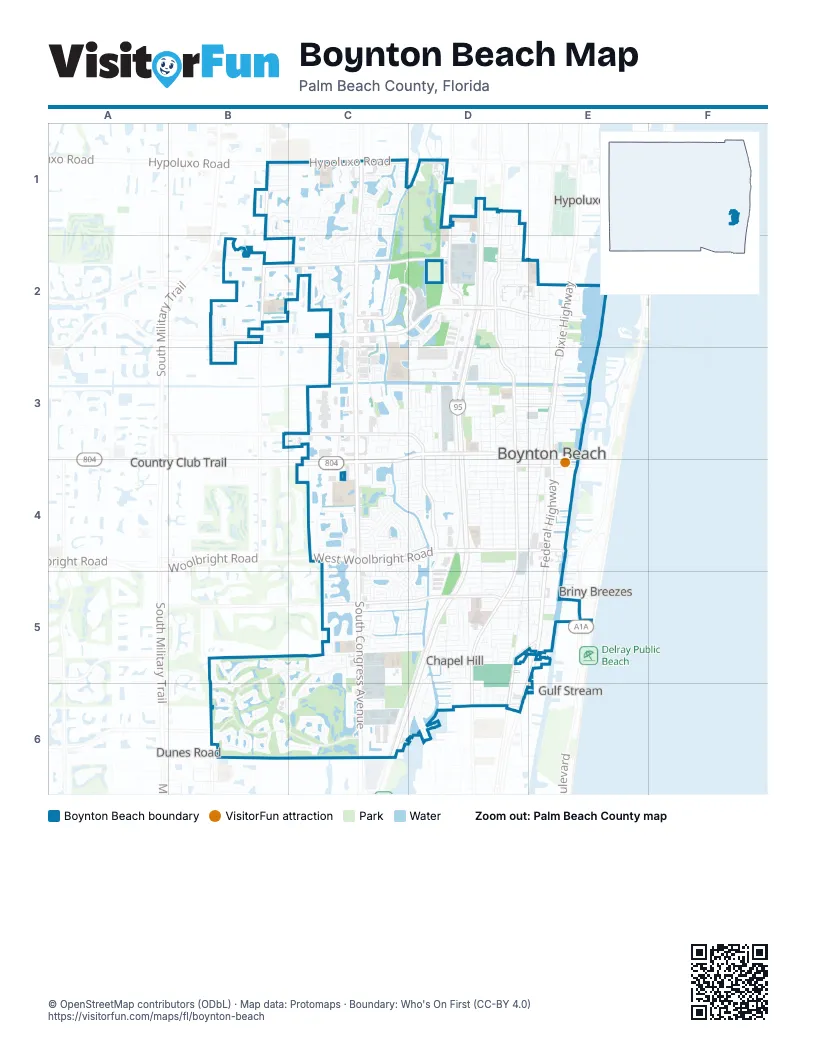
Street index of Boynton Beach
Each street on the sheet and the grid squares it crosses.
- Federal HighwayE3, E4, E5, D6
- West Boynton Beach BoulevardC3, D3, C4
- Dixie HighwayE2, E3
- East Boynton Beach BoulevardD3, E3
- Boynton Beach BoulevardC4
- Gateway BoulevardB2, C2, D2, E2
- North Congress AvenueC1, C2, C3, C4
- South Congress AvenueC1, C4, C5, C6
- West Woolbright RoadC4, D4
- Hypoluxo RoadB1, C1, D1
- East Ocean AvenueD4, E4
- East Woolbright RoadD4, E4
- North Ocean BoulevardE5
- Southwest Golf LaneC4
- Ocean AvenueE4
- North Seacrest BoulevardD1, D2, D3, D4
- High Ridge RoadD1, D2, D3
- Lawrence RoadB1, B2
- South Seacrest BoulevardD4, D5, D6
- Miner RoadB2, C2, D2
- Quantum BoulevardC2, D2
- Southwest 8th StreetD4, D5
- Old Boynton RoadC3, D3
- Southwest 23rd AvenueC5, D5
- North Old Dixie HighwayD5, E5, D6
- Northwest 8th StreetD3, D4
- Golf RoadC5
- Southeast 36th AvenueD6
- Southeast 23rd AvenueD5, E5
- Martin Luther King Jr BoulevardD3, E3
- Old Dixie HighwayE5, D6
- Gulfstream BoulevardD6
- Martin Luther King AvenueE3
- Seacrest BoulevardD6
- Summit DriveB5, C5, B6, C6
- Quantum Lakes DriveC2, D2
- Renaissance Commons BoulevardC2, C3
- Southeast 1st StreetE4, D5, D6
- Southeast 4th StreetE4, E5, D6
- Southwest 18th StreetC4, D4, C5
- Northwest 1st StreetD2, D3, D4
- Palmland DriveC5
- Southwest 4th StreetD4, D5
- Meadows BoulevardC1, C2
- Northwest 7th CourtD1, D2, D3
- Southwest 3rd StreetD4, D5
- Sandalwood DriveC2
- Cranbrook DriveC5
- Ocean ParkwayD1, D2
- Northwest 2nd StreetD2, D3, D4
- Northeast 1st StreetD2, D3, E4
- Knuth RoadC3, C4
- Boynton Lakes BoulevardC1, C2
- Southwest 27th AvenueC5, D5
- Chesapeake CircleC1
- Southeast 2nd StreetE4, D5, D6
- Northwest 4th StreetD2, D3, D4
- 4th Street NortheastD2, E2, E3
- Northwest 7th StreetD2, D3, D4
- West Ocean AvenueC4, D4
- Northwest 3rd StreetD3, D4
- Southwest 3rd AvenueC4, D4
- Southwest 1st StreetD4, D5
- Southwest 28th AvenueC5, D5
- Southwest Congress BoulevardC4
- Southwest 14th AvenueC4, D4
- Meadows CircleC1
- Northwest 13th AvenueC3, D3
- Southwest 26th AvenueC5, D5
- Clubhouse LaneC5, B6, C6
- Chapel Hill BoulevardD5
- Southwest 25th AvenueC5, D5
- Belmont PlaceC4
- Southwest 2nd StreetD4
- Southwest 8th AvenueC4, D4
- Southwest 13th AvenueC4, D4
- Southwest 1st AvenueD4
- Southwest 5th AvenueC4, D4
- Northwest 1st AvenueD3, D4
- Bedford BoulevardB1, C1, C2
- Via Lugano CircleC2
- Sausalito DriveB2
- Asbury WayD4
- Park Ridge BoulevardD3
- Banyan Creek Circle NorthC4
- Southwest 7th AvenueC4, D4
- 1st Court NortheastD2, D3
- Southwest 6th AvenueC4, D4
- Southeast 3rd StreetE4, D5, E5
- Ocean DriveC4, D4
- Savannah Lakes DriveC2, C3
- Northwest 8th AvenueD3
- Northwest 10th AvenueD3
- Southwest 2nd AvenueD4
- Southwest 24th AvenueC5, D5
- Southern Cross CircleC4
- Southwest 15th StreetC4, D4, C5, D5
- Lake Monterey CircleC6
- Southwest 9th AvenueC4, D4
- Southwest 11th AvenueC4, D4
- Estate DriveC1, C2, B6
- Southwest 16th StreetC4, D4, D5
- Southwest 4th AvenueD4
- Stonehaven DriveC4
- Southwest 17th StreetD4, C5
- Westgate LaneB6
- Bermuda Sound WayB2
- Southwest 22nd WayC5, D5
- Northeast 12th AvenueD3, E3
- Northeast 2nd CourtD2, D3, E3
- Villa CircleD5, E5
- South Lake DriveD5, D6
- Southwest 10th AvenueC4, D4
- Lamar Jackson WayC2, C3
- Southwest 25th PlaceC5, D5
- West Industrial AvenueD3
- Northwest 10th CourtC3, C4, D4
- Hampshire LaneB5, C5
- Southwest 27th PlaceC5, D5
- Buttonwood LaneC2
- Railroad AvenueE3
- Lawrence Lake DriveB2
- Mahogany DriveC2
- Paxford LaneC1
- 3rd Street NortheastE2, E3
- Crossings CircleE2
- Mayfair LaneC1, C2
- Grove Park CircleB1
- Southwest 22nd AvenueC5, D5
- Meadows DriveC2
- Southwest 12th AvenueC4, D4
- Southwest 22nd StreetC4, C5
- Winchester Park BoulevardC3, C4
- Northwest 8th CourtD3
- Northeast 7th AvenueD3, E3
- Northwest 6th AvenueD3
- Live Oak LaneC2
- Northeast 9th AvenueD3, E3
- Cedar CircleC2
- High Point Boulevard NorthD5
- 4th Court NortheastD2, E2
- Boynton Bay CircleD2, E2
- Southwest 26th StreetC4, C5
- Southport LaneB6, C6
- Southwest 6th StreetD4, D5
- Nautica Sound BoulevardB1, C1
- Northeast 15th AvenueD3, E3
- Northeast 3rd StreetE3, E4
- Southwest 14th StreetC4, C5
- Southwest 17th AvenueC4, D4
- 26th Avenue NortheastD2, E2
- Inter LagosC2
- Citrus Glen DriveB2, C2
- Southeast 5th CircleD5, E5
- Southwest 30th AvenueC5
- Northwest 5th StreetD2, D3
- Southwest 5th StreetD5
- Southeast 28th CircleD5, E5
- Lake Eden DriveD6
- Northwest 4th AvenueD3
- Providence RoadB1, C1
- 17th Avenue NorthwestD3
- Corporate DriveD4, D5
- Northeast 1st LaneD2
- Meadows Park LaneC1
- Newlake DriveD4
- 20th Avenue NortheastD2, E2
- Northeast 6th AvenueD3, E3
- Northwest 11th AvenueD3
- Manatee Bay DriveE3
- Royal Manor BoulevardB2
- Fairfax Circle EastB1, C1
- Main BoulevardD4
- South BoulevardD4, D5
- Southeast 2nd AvenueD4, E4
- High Point BoulevardD5
- 16th Avenue NortheastD3, E3
- Northwest 11th StreetC3
- White Rock CircleB2
- Buxton LaneC1
- Ridge Pointe DriveD5
- Southwest 11th StreetC5
- Vista del RioC2
- Eastgate DriveC6
- Southeast 28th AvenueD5, E5
- Javert StreetC3
- Mission Hill RoadD5
- Northwoods DriveB5, B6
- Fairfax Circle WestB1, B2, C2
- Rialto DriveC2
- Arezzo CircleC2
- Tuscany WayE5
- Key Lime BoulevardB2
- Diane DriveD5, D6
- Southwest 10th StreetD4, D5
- Baytree CircleC2
- Waterside CircleE5
- Manor Forest BoulevardB2
- Southwest 20th StreetC4, C5
- Cambridge LaneB6
- Southern Cross LaneC4
- Northwest 12th AvenueD3
- North Evergreen CircleC2
- Southwest 13th TerraceC4, D4
- Southwest 19th AvenueC5
- Springfield BoulevardB1, C1
- Wellesley RoadC1, C2
- Northeast 8th AvenueD3, E3
- Lake TerraceC4
- Northwoods LaneB5, B6
- Woods LaneB6
- Executive CircleB2
- Southwest 1st CourtD4
- Coastal Bay BoulevardE5
- Edgewater DriveC4
- Northeast 17th AvenueD2, E2, D3
- Bentwater CircleC1
- Northeast 2nd StreetE3
- Southwest 24th StreetC4, C5
- Pinehurst DriveD4
- Nautica BoulevardB2
- Foster Mills RoadC1, C2
- South Greenleaf CircleC2
- Seaview CircleE3
- Southwest 7th StreetD4, D5
- Southeast 1st CourtD5
- Southwest 25th WayC5, D5
- Magliano DriveC2
- Horizon Street WestE4
- East Chesterfield DriveC1
- Northeast 13th AvenueD3, E3
- Manor Forest LaneB2
- Southeast 1st PlaceD5
- Northeast 4th AvenueD3, E3
- Southeast 31st AvenueD5
- Park TerraceC2, C3
- Southwest 35th AvenueC6, D6
- Northwest 5th AvenueD3
- 3rd Court NortheastE2, E3
- Orange StreetD1, D2
- Southeast 21st AvenueD5, E5
- Northeast 11th AvenueD3, E3
- Southeast 5th AvenueD4, E4
- Misty Meadows DriveC1
- Renaissance DriveC3
- Southeast 34th AvenueD6
- Southwest 9th StreetD4, D5
- Northeast 14th AvenueD3, E3
- Ocean Inlet DriveE3
- Newport AvenueB1, C1
- 14th Avenue NorthwestD3
- Northeast 5th StreetE2, E3, E4
- Laurito LaneC3
- Meadows WayC1
- South Evergreen CircleC2
- Southwest 13th StreetC4, C5
- Sunset RoadD5
- West Ocean DriveD4
- Northeast 4th StreetE2, E3, E4
- Southeast 6th AvenueD4, E4
- Southwest 13th WayC4
- Southeast 1st AvenueD4, E4
- Island DriveC6
- Southeast 26th AvenueD5
- Stirrup Cay CourtB2
- Victory CircleC3
- Industrial AvenueD3
- Southwest 8th PlaceD4
- Post LandingC2
- Southwest 13th PlaceC5, D5
- Northwest 25th AvenueD2
- North Swinton AvenueD5, D6
- Westlake DriveC6
- Campanelli BoulevardC5, D5
- Nocelle DriveC3
- Northeast 6th CourtE3
- Stratford Drive EastB6
- Northeast 6th StreetE2, E3, E4
- Orange DriveB2, C2
- Catalina Centre North DriveC3
- Horizon Street EastE4
- Swallow DriveC1, C2
- Leisureville BoulevardC3, C4
- Grove RoadD2
- Neptune DriveC6
- Colonial Club DriveE5
- Northwest 10th StreetD3
- Greenbriar DriveE4
- Mystic Harbor CircleB2
- Southeast 12th AvenueD4, E4
- High Point CourtD5
- Bristol LaneB5, B6, C6
- Dogwood CircleC1, C2
- Southwest Lake CourtC4
- East Atlantic DriveD1, D2
- Northeast 20th LaneE2
- Tara Lakes Drive EastC4
- Northwest 9th AvenueD3
- Southwest 16th AvenueC4, D4
- Banyan Creek CourtC4
Things to do on the Boynton Beach map
Places on the map
- Bethesda Hospital East
- Boynton Beach Mall
- Boynton Beach Memorial Park
- Boynton Commerce Center
- Boynton Commons
- Boynton Festive Center
- Boynton Lakes Park
- Boynton Lakes Plaza
- Boynton Plaza
- Boynton Town Center
- Caloosa Park
- Catalina Centre
- Citrus Cove Elementary School
- Crosspointe Elementary School
- Egret Point Logistics Center
- Forest Park Elementary School
- Galaxy Park
- Grove Plaza
- Heart of Boynton Village
- High Ridge Country Club
- Hunters Run
- Lago Marissa
- Lago Nerina
- Lake Constantino
- Lake Leisureville
- Lake Worth Christian School
- Mangrove Park
- Meadows Square
- Oakwood Square
- Palmetto Greens Linear Park
- Quantum Town Centre
- Quantum Village
- Renaissance Commons
- RISE Academy
- Riverwalk Plaza
- Rolling Green Scrub
- Rosemary Scrub Natural Area
- Seacrest Scrub Natural Area
- Shoppes of Boynton
- Shoppes of Woolbright
Next to Boynton Beach
- Briny Breezes
- Country Club Trail
- Delray Gardens
- Dunes Road
- Gulf Stream
- Hypoluxo
- Manalapan
- Ocean Ridge
© OpenStreetMap contributors, Open Database License, openstreetmap.org/copyright · Map data: Protomaps · Boundary: Who's On First (CC-BY 4.0)















