

Florida map
Clay County map
About 236,760 people live here (Census Bureau, 2024 estimate). The sheet's index lists 33 streets; First Coast Expressway, Blanding Boulevard and Doctors Inlet Road cross the most grid squares. Also on it: Antler's Run, ARIUM Orange Park and Asbury Lake.
Open the map (PDF, US Letter)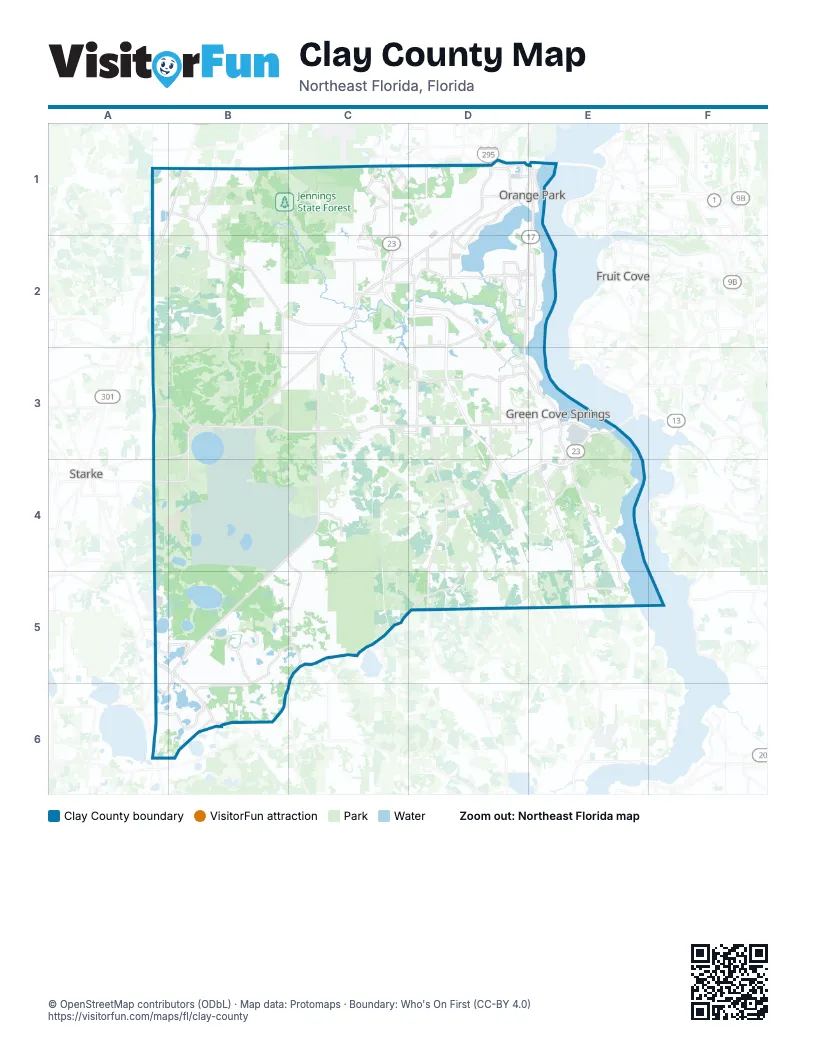
Street index of Clay County
Each street on the sheet and the grid squares it crosses.
- US 301 Highway SouthB1
- Challenger DriveC1
- Discovery DriveC1
- First Coast ExpresswayC1, C2, D2, D3, E3, D4, E4
- Oakleaf Plantation ParkwayC1
- Oakleaf Village ParkwayC1
- Blanding BoulevardD1, C2, D2, C3
- College DriveD1, D2
- Kingsley AvenueD1, E1
- Wells RoadD1, E1
- West BeltwayD1, E1
- Eldridge AvenueE1
- Park AvenueE1
- Baxley RoadC2
- Branan Field RoadC2
- Doctors Inlet RoadC2, D2, E2
- County Road 220D2
- Henley RoadD2, D3
- Cathedral Oak ParkwayD3
- Springbank RoadD3, D4
- US Highway 17D3, E3
- Ferris StreetE3
- Idlewild AvenueE3
- Leonard C. Taylor ParkwayE3
- North Orange AvenueE3
- Oakridge Avenue SouthE3, E4
- Orange AvenueE3
- Shands BridgeE3
- Hogarth RoadD4
- Walker DriveA5, B5
- North Lawrence BoulevardB5
- South Lawrence BoulevardB5, A6, B6
- Bardin RoadD5
Places on the map
- Antler's Run
- ARIUM Orange Park
- Asbury Lake
- Asbury Plantation
- Azalea Ridge
- Baptist Clay Medical Campus
- Bellair-Meadowbrook Terrace
- Belmore State Forest
- Belmore State Forest Ates Creek Tract
- Big Johnson Lake
- Black Creek Ravines Conservation Area
- Black Creek Village
- Blue Pond
- Brookstone at Eagle Harbor
- Camp Blanding Joint Training Center
- Camp Blanding Wildlife Management Area
- Camp Chowenwaw
- Clay County
- Clay County Fairgrounds
- Country Club of Orange Park
- Crosby Sanctuary
- Crystal Lake
- Deer Springs Road
- Doctors Lake
- Eagle Harbor Golf Club
- Eagle Nest Lane
- Edgewater Landing
- Farm Way
- First Coast Expressway
- Fleming Island High School
- Gator Bone Lake
- Gold Head Branch State Park
- Grand Mesa Circle
- Green Cove Springs
- Green Cove Springs Marina
- Hall Lake
- Harbor Island
- HCA Florida Orange Park Hospital
- HCA Middleburg Emergency
- Hidden Oaks Ranch
Next to Clay County
- Fruit Cove
- Starke
© OpenStreetMap contributors (ODbL) · Map data: Protomaps · Boundary: Who's On First (CC-BY 4.0)