

Florida map
Davie map
About 112,052 people live here (Census Bureau, 2024 estimate). The sheet's index lists 300 streets; Port Everglades Expressway, Southwest 36th Street and Southwest 148th Avenue cross the most grid squares. Things to do inside the boundary: Flamingo Gardens.
Open the map (PDF, US Letter)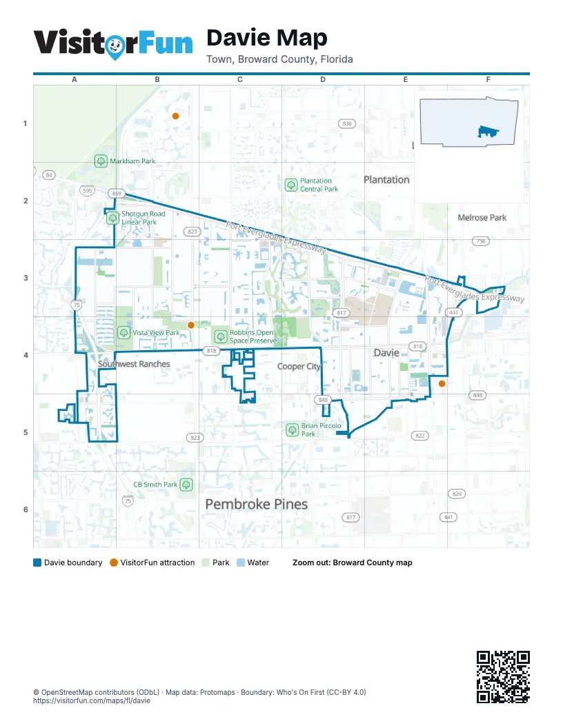
Street index of Davie
Each street on the sheet and the grid squares it crosses.
- Port Everglades ExpresswayA2, B2, C2, D2, D3, E3, F3
- Florida's TurnpikeE3, E4
- Sawgrass ExpresswayA2, B2
- Griffin RoadA4, C4, D4, E4, F4
- South University DriveD3, D4, D5
- Stirling RoadA5, D5, E5
- South Flamingo RoadB2, B3, B4
- South State Road 7F3, E4, F4
- North University DriveD5
- Marina Mile BoulevardF3
- Sheridan StreetA5
- South Pine Island RoadD3, D4, D5
- Davie RoadE3, E4, D5, E5
- Southwest 136th AvenueB2, B3, B4
- Nob Hill RoadC3, C4
- South Nob Hill RoadC2, C3
- Hiatus RoadC2, C3, C4
- Weston RoadA3, A4
- Southwest 88th AvenueD3, D4
- Davie Road ExtensionD5, E5
- Southwest 160th AvenueA4, A5
- Northwest 136th AvenueB2
- Pine Island RoadD5
- Southwest 100th AvenueC4
- Orange DriveA4, B4, C4, D4, E4
- Southwest 36th StreetD3, E3, F3, A4, C4, D4, F4
- Nova DriveC3, D3, E3
- Southwest 26th StreetA3, B3, C3, D3
- Southwest 130th AvenueB2, B3, B4
- Shenandoah ParkwayB2
- Shotgun RoadA2, B2, A3, A4
- Southwest 30th StreetA3, C3, D3, E3, F3
- Pine Ridge DriveC3, D3
- Southwest 14th StreetA3, B3, C3
- Southwest 148th AvenueA2, B2, A3, A4, A5, B5
- Southwest 39th StreetA4, B4, D4, E4
- Southwest 76th AvenueD3, D4, D5
- Southwest 61st AvenueE3, E4, E5
- College AvenueE3, E4
- Southwest 36th CourtE3, B4, C4
- Southwest 70th AvenueE3, E4, E5
- Southwest 112th AvenueC2, C3
- Boyscout RoadB3, B4
- Southwest 58th AvenueE3, E4, E5
- Southwest 31st CourtA3, B3, E3
- Southwest 53rd AvenueE3, E4, E5
- Southwest 45th StreetA4, B4
- Northwest 68th AvenueE5
- North 66th AvenueE5
- Carriage DriveE5
- Southwest 148th LaneB5
- Stirling Access RoadE5
- BridgeB4, C4
- Indian TraceA3
- South Post RoadA4
- Winkopp BridgeB4
- North 64th AvenueE5
- International ParkwayB2
- Commodore DriveB2
- Northwest 72nd AvenueE5
- Frontage RoadB2, B3, D3, B4
- Southwest 20th StreetA3, B3, C3, D3
- Southwest 41st StreetA4, B4, D4, E4
- Forest Ridge CircleC3, D3
- Hawkes Bluff AvenueA4, A5
- Southwest 40th StreetA4, B4, C4, D4, E4
- Southwest 121st AvenueC2, C3, C4
- Southwest 16th StreetA3, B3, C3, D3
- Orange Grove DriveD3
- Southwest 23rd StreetA3, B3, C3, D3, E3
- Southwest 82nd AvenueD3, D4, D5
- Southwest 117th AvenueC2, C3, C4
- Southwest 106th TerraceC3, C4
- Southwest 139th AvenueB3, B4
- Southwest 35th StreetD3, E3, A4, D4
- Southwest 17th StreetA3, B3, C3, D3
- Southwest 21st StreetA3, B3, C3, D3
- Reese RoadE3
- Southwest 52nd AvenueE3, E4
- Southwest 115th AvenueC3, C4
- Southwest 85th AvenueD3, D4
- Southwest 116th AvenueC3, C4
- Southwest 51st StreetA4, C4, D4, E4
- Southwest 41st CourtD4, E4
- Southwest 22nd CourtC3, D3, E3
- Southwest 43rd StreetB4, C4, E4
- Southwest 37th CourtB4, C4, D4, E4
- Southwest 55th AvenueE3, E4
- Southwest 111th TerraceC2, C3, C4
- Southwest 18th StreetC3, D3
- Southwest 87th TerraceD3, D4
- Southwest 14th PlaceB3, C3
- Southwest 57th StreetD4, E4
- Southwest 131st TerraceB2, B3
- Southwest 38th CourtA4, D4, E4
- Southwest 42nd StreetB4, E4
- Southwest 8th StreetB2, C2
- Southwest 24th StreetA3, B3, C3
- West Park BoulevardB2
- Southwest 16th CourtB3, C3, D3
- Southwest 75th AvenueD3, E4
- Southwest 145th AvenueB3
- Southwest 44th StreetB4, C4, E4
- Southwest 86th AvenueD3
- Broward CollegeE3, E4
- Southwest 73rd AvenueD4
- Southwest 28th StreetA3, B3, D3
- Southwest 83rd TerraceD3, D4
- Harmony Lakes CircleC3
- Cameron CourtC2
- Southwest 71st TerraceD3, E3, E4
- Southwest 9th PlaceB2, C2
- Southwest 42nd CourtC4, D4, E4
- Southwest 127th AvenueB3
- Southwest 26th CourtB3, C3, D3
- Southwest 13th StreetB3, C3
- Southwest 54th AvenueE3, E4, E5
- Southwest 48th StreetE4
- Southwest 18th CourtA3, B3, C3, D3
- Southwest 81st AvenueD3
- Southwest 39th CourtD4, E4
- Birch TerraceC3, C4
- Burris RoadE3, F3
- Southwest 72nd WayD3, D4
- Southwest 17th CourtA3, B3, C3, D3
- Southwest 29th StreetB3, D3, E3
- Southwest 27th CourtA3, B3, C3, D3
- Southwest 37th StreetA4, E4
- Southwest 34th StreetA3, E3
- Southwest 9th CourtB2, C2
- Northwest 77th AvenueD5, E5
- Southwest 25th StreetA3, C3
- White Hall DriveD3
- Old Orchard RoadD3
- Southwest 24th PlaceA3, D3, E3
- Northwest 78th AvenueD5
- Kean RoadE3, E4
- Countrysie CircleC3
- Southwest 92nd AvenueD4
- Southwest 38th StreetA4, E4
- Southwest 133rd AvenueB2
- Southwest 31st StreetA3, B3, C3, E3
- Southwest 27th StreetA3, C3, D3
- Southwest 47th AvenueE3, E4
- Northwest 39th StreetD5, E5
- Southwest 65th AvenueE4
- Southwest 21st CourtC3, D3, E3
- Southwest 84th AvenueD3
- Southwest 34th PlaceB3, E3
- Southwest 109th AvenueC3, C4
- Southwest 29th CourtB3, C3, D3
- Falconsgate AvenueA5
- Scarborough DriveC2
- Canal DriveF3
- Southwest 49th StreetA4, D4, E4
- Southwest 132nd WayB3
- Palm Trace Landings DriveE3
- Derby DriveB4
- Southwest 33rd StreetA3, E3
- Southwest 150th AvenueA3, A4
- Rick Case Honda WayA4
- Poinciana PlaceD3
- Southwest 57th PlaceC4, E4
- Southwest 59th AvenueE3, E4
- Oak Park CircleD3
- Southwest 131st AvenueB2, B4
- Southwest 5th CourtB2
- Palomino DriveA4, E5
- Southwest 30th CourtB3, C3
- West Wedgewood AvenueA5
- Southwest 83rd AvenueD3
- Southwest 7th PlaceB2
- Appalachian TrailB2
- Southwest 33rd CourtB3
- Southwest 10th CourtB2, C2
- Northwest 33rd StreetD5, E5
- Southwest 41st PlaceD4, E4
- Southwest 58th CourtE4
- Southwest 35th PlaceE3, B4
- Southwest 22nd StreetA3, C3, D3
- Southwest 15th CourtB3, C3, D3
- Southwest 38th DriveC4
- Southwest 60th AvenueE3, E4
- Southwest 27th PlaceD3
- West Falcons Lea DriveA5
- Southwest 101st AvenueC3, C4
- Southwest 6th CourtB2
- Nova Village DriveD3
- Southwest 120th WayC2, C3
- Southwest 55th StreetC4, E4
- Ridge TraceC3
- Southwest 42nd PlaceC4, D4, E4
- Arborwood CircleD3
- Southern Orchard Road NorthD3
- Southwest 100th TerraceC3, C4
- Southwest 56th StreetE4
- Southwest 58th StreetE4, C5, E5
- Southwest 133rd TerraceB2, B3
- Parkway DriveC3
- Southwest 50th AvenueE3, E4
- Southwest 118th TerraceC2, C3
- Southwest 15th PlaceA3, B3, C3
- Southwest 73rd WayD3
- Southwest 15th ManorB3, C3
- Southwest 16th PlaceC3, D3
- Southwest 109th TerraceC2, C3, C4
- Southwest 20th PlaceD3, E3
- Southern Orchard Road SouthD3, D4
- Southwest 44th CourtC4, D4, E4
- Southwest 11th PlaceB2, C2, C3
- Southwest 81st TerraceD3
- Southwest 7th CourtB2, C2
- Oak Ridge DriveB2
- Castlegate AvenueA4, A5
- Southwest 87th AvenueD3
- Southwest 20 StreetA3
- Bright RoadC2, C3
- Southwest 56th AvenueE4
- Southwest 22nd PlaceB3, C3, D3
- Southwest 79th AvenueD3
- Cumberland TerraceB2
- Southwest 23rd CourtA3, B3, C3, E3
- Southwest 62nd AvenueE4
- Hidden Hollow LaneC3, D3
- Southwest 66th TerraceE3, E4
- Southwest 67th AvenueE4
- Peppertree Circle NorthD4, E4
- Oak Grove CircleD3
- Southwest 11th CourtB2, C2
- Rexmere BoulevardC2
- Peppertree Circle SouthE4, D5, E5
- Southwest 48th CourtD4, E4
- Southwest 59th StreetC5, E5
- Mary Mccahill DriveD3, E3, E4
- Southwest 23rd PlaceC3, D3
- Southwest 141st TerraceB3, B4
- East Lake Estates DriveD3, D4
- Southwest 102nd DriveC3
- Southwest 19th CourtC3, D3
- Southwest 63rd AvenueE3, E4
- Southwest 135th TerraceB2, B3
- Southwest 108th WayC2, C3
- Toscana DriveE3
- Southwest 15th StreetA3, B3, D3
- Stonebrook DriveB3
- Southwest 54th StreetC4, E4
- Southwest 70th TerraceE3, E4
- Southwest 29th PlaceA3, B3, C3
- Southwest 40 StreetB4
- Southwest 57th TerraceE4
- Laurel Oaks DriveC4
- Southwest 105th AvenueC3, C4
- Southwest 13th PlaceC3
- Southwest 141st AvenueB4
- Southwest 105th TerraceC3
- Fire AcademyD3, E3
- Southwest 137th TerraceB3
- Huntridge RoadA4, A5
- Southwest 59th CourtE5
- University Office ParkD4
- Forest Ridge BoulevardD3
- Peachtree CircleD3
- Southwest 5th StreetB2
- Southwest 17th DriveC3
- Northwest 38th StreetD5, E5
- Southwest 113th AvenueC3, C4
- Southwest 51st CourtC4, E4
- Southwest 28th CourtB3, C3
- South Waterford DriveA5
- Southwest 67th TerraceE4
- Southwest 17th PlaceB3, C3, D3
- Southwest 34th CourtA3, B3
- Southwest 110th TerraceC2, C3, C4
- Southwest 74th TerraceD3, D4
- Southwest 112th WayC2, C3
- Southwest 84th TerraceD3, D4
- Southwest 7th StreetB2
- East Oak Knoll CircleC3
- Evergreen PlaceD3
- Rolling Hills CircleD3
- Pine Lodge TrailC3
- Southwest 134th AvenueB2, B4
- Southwest 46th AvenueE3, E4
- Southwest 114th WayC2, C3, C4
- Lone Star PlaceC3
- Southwest 55th CourtD4, E4
- Clubhouse DriveC3
- Southwest 9th StreetB2, C2
- Southwest 116th WayC2, C3
- Rock Hill AvenueB2
- Gateland VillageD5
- Amherst AvenueB2
- Southwest 139th TerraceB3
- Gulfstream WayC3, C4
- Southwest 12th CourtC2, B3, C3
- West Lake Estates DriveD4
- Southwest 32nd StreetC3, E3
- West Stonebrook CircleB3
- Churchill Downs DriveC3, C4
- Southwest 129th WayB2, B3
Things to do on the Davie map
Places on the map
- 595 Park of Commerce
- Advance Auto Parts
- Alvin Sherman Library, Research, and Informantion Technology Center
- Ashley HomeStore
- Davie Fire / Rescue Station 38
- Davie Golf and Country Club
- Davie Pine Island Park
- Davie Shopping Center
- Flamingo Elementary School
- Flamingo Gardens
- Fox Trail Elementary School
- Grande Oaks Golf Club
- Indian Ridge Middle School
- Lakeside Town Shops
- Long Key Natural Area
- Nova Southeastern University
- Orange Drive Linear Park
- Pine Island Ridge Golf Course
- Pine Island Ridge Natural Area
- Pond Apple Slough
- Robbins Open Space Preserve
- Saint David Catholic School
- Shenandoah Park
- Shenandoah Square
- Sunny Lake Park
- The UPS Store
- Tower Shops
- Tree Tops Park
- United States Post Office
- Van Kirk Park
- Vista View Park
- Walmart
- Waverly Park
- Waverly Park Trail
- Western High School
- Westlawn Memorial Gardens
- Weston Road Shopping Center
- Westport Plaza
- Wolf Lake
- Wolf Lake Park
Next to Davie
- Cooper City map
- Lauderhill map
- Melrose Park
- Pembroke Pines map
- Plantation map
- Southwest Ranches
© OpenStreetMap contributors, Open Database License, openstreetmap.org/copyright · Map data: Protomaps · Boundary: Who's On First (CC-BY 4.0)















