

Florida map
Delray Beach map
About 70,140 people live here (Census Bureau, 2024 estimate). The sheet's index lists 300 streets; South Congress Avenue, West Atlantic Avenue and Federal Highway cross the most grid squares. Things to do inside the boundary: Delray Yacht Cruises and Sandoway Discovery Center.
Open the map (PDF, US Letter)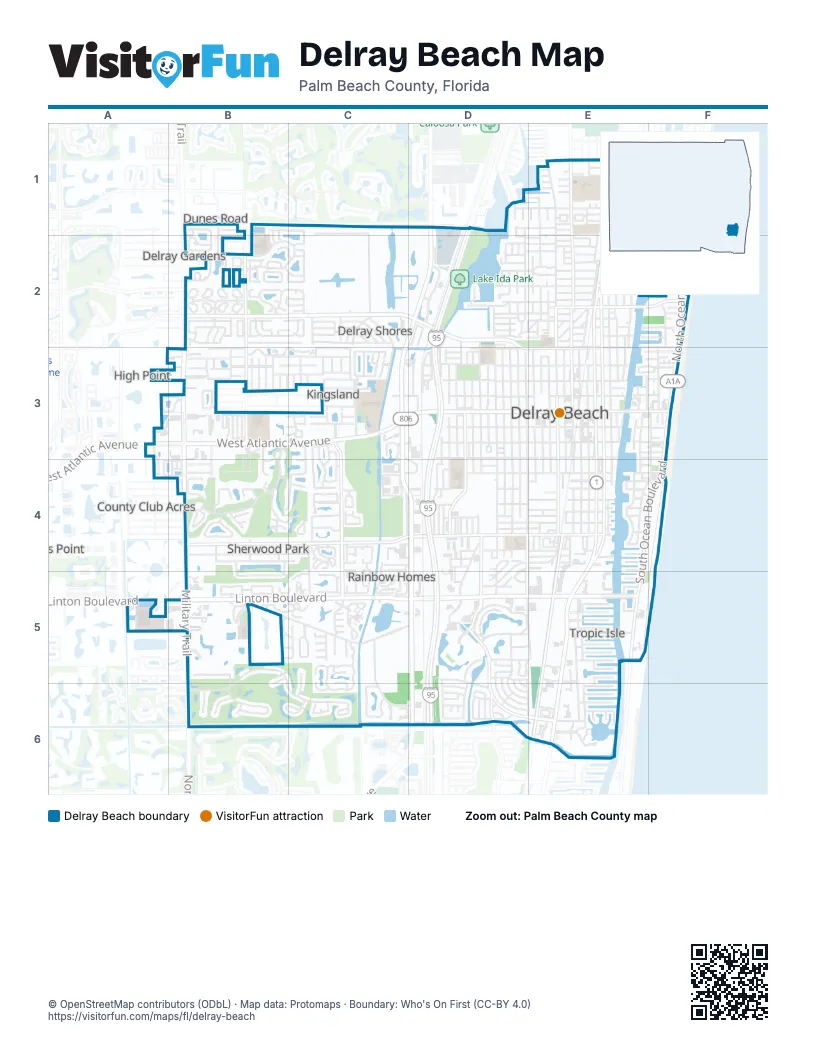
Street index of Delray Beach
Each street on the sheet and the grid squares it crosses.
- West Atlantic AvenueA3, B3, C3, D3, E3
- Federal HighwayE1, E2, E4, E5, E6
- Southeast 5th AvenueE3, E4
- Northeast 6th AvenueE2, E3
- Southeast 6th AvenueE3, E4
- East Atlantic AvenueE3, F3
- Northeast 5th AvenueE2, E3
- Linton BoulevardA5, B5, C5, D5, E5
- South Congress AvenueD1, C3, C4, D4, D5, D6
- Military TrailB3, B4, B5, B6
- North Congress AvenueD1, C2, D2, C3
- South Ocean BoulevardF3, E4, F4, E5
- East Linton BoulevardE5
- North Ocean BoulevardF2, F3
- Congress AvenueD6
- Lake Ida RoadB2, C2, D2, D3, E3
- Homewood BoulevardC3, C4, C5
- North Swinton AvenueE1, E2, E3
- Lowson BoulevardB4, C4, D4
- Barwick RoadB1, B2, B3
- Southwest 4th AvenueD3, D4, E4, D5, E5
- South Dixie HighwayE4, E5, E6
- Northeast 2nd AvenueE1, E2, E3
- Southwest 10th AvenueD3, D4, D5
- Lindell BoulevardD5, D6, E6
- South Swinton AvenueE3, E4
- Old Dixie HighwayE1, E2
- Southwest 10th StreetD4, E4
- Southwest 14th AvenueD3, D4
- George Bush BoulevardE2, F2
- Southwest 12th AvenueD3, D4
- Northeast 4th StreetE3
- Southeast 10th StreetE4
- Seacrest BoulevardE1
- Auburn AvenueD4
- Southeast 36th AvenueE1
- Northeast 14th StreetE2
- Northeast 8th StreetE2
- Carl Bolter DriveD6
- North Dixie HighwayE6
- Brant DriveD6
- Hamlet DriveB3, B4
- Alta Meadows LaneD5
- Germantown RoadB5, C5, D5
- Live Oak BoulevardB5, B6, C6
- Northeast 3rd AvenueE1, E2, E3
- Northwest 3rd StreetB3, D3, E3
- Northwest 4th AvenueD1, D2, D3
- Southwest 8th AvenueD3, D4, D5
- Davis RoadC1, C2, C3
- Sherwood Forest DriveB3, B4
- Southwest 2nd StreetC3, D3, E3
- North High Point BoulevardC3
- Northwest 2nd StreetB3, C3, D3, E3
- Orchard LaneB5
- Northwest 2nd AvenueE1, E2, E3
- Southwest 6th AvenueD3, D4
- Via DesteB3
- Palm TrailE1, E2, E3
- Southwest 7th AvenueD3, D4
- Sherwood BoulevardB4, C4
- Southwest 3rd StreetC3, D3, E3
- Sabal Lakes RoadB2, C2
- Lavers CircleD5
- Northwest 3rd AvenueE1, E2, E3
- Lake Ida Park Internal Access RoadD1, D2
- Southeast 2nd AvenueE3, E4
- Southeast 3rd AvenueE3, E4
- Southeast 4th AvenueE3, E4
- Northwest 6th AvenueD2, D3
- Northwest 18th AvenueD1, D2, D3
- Andrews AvenueF2, F3
- Northeast 7th AvenueE2, E3
- Southwest 1st StreetD3, E3
- Southwest 22nd AvenueC4, C5, C6
- Northwest 5th AvenueD2, D3
- Northwest 10th StreetB2, C2, D2
- Northeast 8th AvenueE2, E3
- Northwest 9th StreetB2, C2, D2, E2
- Northwest 1st StreetC3, D3, E3
- Northwest 1st AvenueE1, E2, E3
- High Point BoulevardC3
- Southwest 4th StreetC4, D4, E4
- Southeast 7th AvenueE3, E4
- Depot AvenueD2, D3
- Southwest 5th AvenueD3, D4
- Greensward LaneB4, C4
- Northwest 12th StreetC2, D2, E2
- Spanish TrailE5, E6
- Southwest 2nd AvenueE3, E4
- Northwest 8th AvenueD2, D3
- Northwest 13th StreetC2, D2
- Catherine DriveC5
- Bexley Park DriveB2
- Coral Trace BoulevardC3
- Linton Lake DriveC5
- Crystal WayD5
- Northwest 22nd AvenueC1, C2
- Northwest 18th StreetC1, D1, E1
- Florida BoulevardE5, E6
- Park of Commerce BoulevardD2
- Southeast 1st AvenueE3, E4
- Southwest 15th AvenueD3, D4
- Classical BoulevardB1, B2
- Southeast 2nd StreetE1, E3
- Commerce DriveC4
- Lake DriveD1, D2
- Fountains WayD2, A3, B3
- Seasage DriveE4
- Southwest 7th StreetD4, E4
- White Cedar LaneB6
- Northwest 14th StreetC2, D2
- Southwest 11th AvenueD3, D4
- Northwest 15th StreetC2, D2, E2
- Village DriveB3, C3
- Riviera DriveC2
- South DriveB3, C3
- Southeast Dorson WayC2
- Pineview CircleB4
- Lakeview BoulevardB4, C4
- Rabbit Hollowe CircleC5
- Jaeger DriveD5, D6, E6
- North DriveB3, C3
- Southridge RoadD4, E4, D5
- Southwest 20th TerraceC4, D4, C5, C6, D6
- Spring Harbor DriveC5, D5
- Southwest 22nd CircleC6
- Southwest 6th StreetC4, D4, E4
- Heron DriveD5, D6, E6
- Lakeview DriveB4, B5
- Dotterel RoadD5, E5
- Seagate DriveE4, F4
- Northwest 10th AvenueD2, D3
- Wallace DriveD4, D5
- Venetian DriveE3, E4
- Northwest 7th CourtB2, C2
- Northeast 2nd StreetE3
- Ponce de Leon BoulevardC4
- Northwest 4th StreetB3, D3
- Waterford PlaceD5
- Southwest 13th AvenueD3, D4
- Northeast 3rd StreetE3
- Northeast 1st StreetE3
- Pelican WayE6
- Southwest 27th AvenueC3, C4, C5
- Southwest 8th StreetD4, E4
- Southeast 1st StreetE1, E3
- Northwest 7th AvenueD3
- Northwest 7th StreetD2, E2
- Gleason StreetF3, F4
- Congress Park DriveC3, C4
- Southwest 9th StreetD4, E4
- Southwest 1st AvenueE3, E4
- High Point DriveC3
- Northwest 11th StreetD2, E2
- Southeast 5th StreetE4
- Frances DriveB3, C3
- Egret CircleD5
- Northwest 19th TerraceD1, C2, D2
- Satin Leaf CourtB1, C1, C2
- Southwest 26th TerraceC5
- Northeast 5th StreetE2
- Southwest 15th StreetC5
- Northwest 13th AvenueD2, D3
- Estates DriveB4
- Audubon BoulevardD5, D6
- Cormorant RoadD6
- Northwest 23rd AvenueC3
- Dover RoadC4, C5
- Northwest 3rd CourtB3
- Southeast 3rd StreetE3
- Brandon DriveB2, C2
- Lone Pine RoadC1
- Northeast 1st AvenueE3
- Southwest 3rd AvenueE3, E4
- Glenwood DriveC3, C4
- Northwest 6th StreetB2, C2, E2
- Southeast 4th StreetE4
- High Point Boulevard WestB3
- Bloods Grove CircleB5
- Sea Grape CircleB2
- Northwest 20th AvenueC1, C2
- Southeast 8th StreetE4
- Estuary TrailE2
- Northwest 17th StreetE1, C2, D2, E2
- Northeast 22nd StreetE1
- Tropic BoulevardE5
- Vista del Mar Drive NorthE3, F3
- Valencia DriveB5
- Northwest 23rd LaneC2
- Enfield RoadD2, E2
- Palm Cove BoulevardC5
- Cherry Laurel LaneB5, B6
- Foxpointe CircleB4
- Northeast 12th StreetE2
- Par CircleC4
- Southwest 17th AvenueD4
- Northeast 6th StreetE2
- East Rainberry CircleC2
- Southeast 7th StreetE4
- Northwest 9th AvenueD3
- Southwest 20th CourtC4, D4
- Northeast 13th StreetE2
- Greensward CourtB4
- Northeast 4th AvenueE3
- Modern DriveB1, B2
- West Lakewoode CircleB4
- Southwest 8th CourtD4, E4
- Pine Lake DriveB4, C4
- Northwest 6th CourtB2
- South Rainberry CircleC2
- Delray Lakes DriveD2
- Northwest 50th AvenueB2, B3
- Northwest 29th AvenueC2
- Southwest 13th StreetC4, C5
- Northeast 11th StreetE2
- River Birch CircleB6, C6
- Northwest 16th StreetC2, D2, E2
- Albatross Road NorthD5
- Northwest 11th AvenueD3
- Lake Shore DriveD2
- Northeast 10th StreetE2
- Hammock CircleB5
- Jasmine DriveE6
- Northwest 12th AvenueD3
- Southwest 28th AvenueC3, C4
- Cortez LaneC2
- Northeast 9th StreetE2
- Northeast 17th StreetE1, E2
- Southwest 9th CourtD4, E4
- Ibis DriveD5, D6, E6
- Northeast 16th StreetE2
- Delray Community HospitalA5, B5
- Anchor PointD2
- Northwest 22nd StreetD1, E1
- Eve StreetE5
- North Dixie BoulevardE2
- Southeast 9th StreetE4
- Avocet RoadD6
- Southwest 29th AvenueC3, C4
- Northwest 14th AvenueD3
- Beach DriveE2, F2, E3
- Northwest 46th AvenueB2, B3
- Northwest 49th AvenueB2
- Linton Ridge CircleD5
- Dunlin RoadD5, D6
- Wood Pine DriveB3
- Curlew RoadD5
- Gramercy Square DriveA4, B4
- Coconut Key LaneA3, A4
- Rainberry Lake DriveC2, D2
- Chatelaine BoulevardB2, C2
- Harbor DriveE2, F2
- Northeast 7th StreetE2
- Albatross RoadD5, D6, E6
- Kokomo Key LaneE1
- Dogwood DriveE5
- Pelican Pointe DriveE6
- Oakview DriveB3, B4
- Southwest 21st TerraceC5, C6
- Sandpiper LaneB2, F3
- Silver Oak CircleC6
- South Drive CircleB3, C3
- North Citation DriveB5
- Seabreeze AvenueE3
- Northwest 5th StreetB2
- Southwest 17th CircleC5
- Southwest 9th AvenueD3
- Roosevelt AvenueD2, D3
- Southeast 6th StreetE4
- La Mat AvenueE5, E6
- Northeast 9th AvenueE2
- Iris DriveE6
- Red Maple CircleC6
- Spanish Wells DriveB5, C5
- Delray Bay DriveE6
- Northwest 8th StreetB2, C2, E2
- North Rainberry CircleC2
- Frederick BoulevardE5, E6
- Hummingbird LaneB2
- Carol Trace BoulevardC3
- Estuary WayE2
- Sunflower AvenueB2
- Lincoln RoadB4
- Southwest 35th AvenueC5
- Udell LaneC2
- Flamingo LaneB2
- Northeast 19th StreetE1
- Whippoorwill LaneB2
- Seaspray AvenueE3, F3
- Mockingbird LaneB2
- Bluebird LaneB2
- Cardinal LaneB2
- Northwest 26th AvenueC2
- Whatley RoadB3, B4
- Privade CircleB3
- Meadowlark LaneB2
- Club Drive WestB3
- Bucida RoadE4, F4
- Mac Farlane DriveE3
Things to do on the Delray Beach map
Places on the map
- 344 Palm Trail
- Ace Hardware
- Advance Auto Parts
- ALDI
- Atlantic Dunes Park
- Atlantic Hideaway
- Atlantic High School
- AutoZone
- Banyan Creek Elementary School
- BocaRay Plaza
- Carver Middle School
- Delaire Country Club
- Delray Beach City Hall
- Delray Beach Golf Club
- Delray Beach Plaza
- Delray Beach Public Library
- Delray Crossing
- Delray Medical Center
- Delray Oaks Natural Area
- Delray Place
- Delray Post Office
- Delray Square
- Delray Town Center
- Fair Oaks Pavilion
- Harbor Plaza
- Lake Ida Park
- Lakeview Golf Club
- Linton Square
- Marketplace Delray
- Pine Ridge Cemetery
- Pinecrest Rehabilitation Hospital
- Pompey Park
- Sherwood Park Golf Club
- The Plaza at Delray
- The Seagate Country Club
- The UPS Store
- United States Post Office
- USPS
- Village Academy
Next to Delray Beach
- County Club Acres
- Delray Gardens
- Dunes Road
- Franwood Pines
- Gulf Stream
- High Point
- Kings Point
© OpenStreetMap contributors, Open Database License, openstreetmap.org/copyright · Map data: Protomaps · Boundary: Who's On First (CC-BY 4.0)















