

Florida map
North Palm Beach map
About 13,423 people live here (Census Bureau, 2024 estimate). The sheet's index lists 156 streets; Prosperity Farms Road, Jack Nicklaus Drive and Lakeside Drive cross the most grid squares. Also on it: Munyon Island, John D MacArthur Beach State Park and Anchorage Park.
Open the map (PDF, US Letter)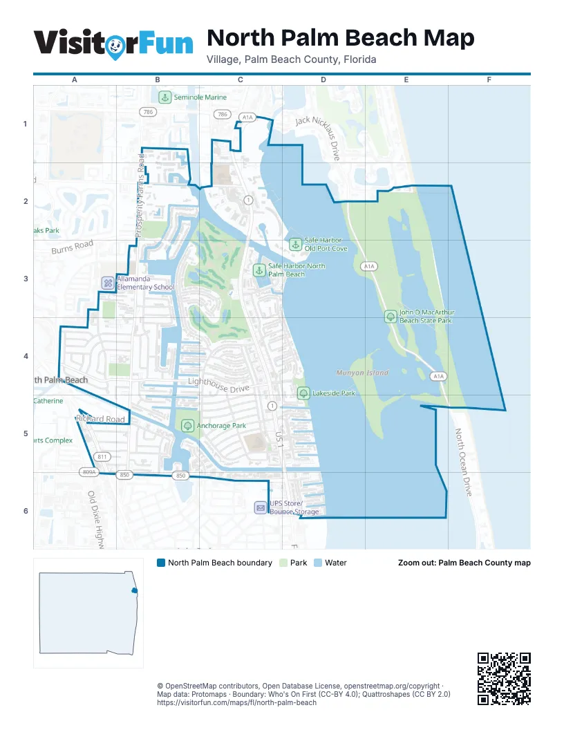
Street index of North Palm Beach
Each street on the sheet and the grid squares it crosses.
- Canal RoadB1
- Charleston CircleB1
- Lyford Cay DriveB1
- Maritime WayB1, B2
- Sandy Point LaneB1
- Voyager LaneB1
- West Teach RoadB1
- Briarwood PlaceC1
- Glen Oaks CourtC1
- Indian Shore DriveC1
- Landing PlaceC1
- Riverwood PlaceC1
- Sandy Oaks CourtC1
- Twelve Oaks WayC1
- Burns RoadB2
- Cable Beach LaneB2
- Harbour IslesB2, B3
- Harbour Isles CourtB2, B3
- Harbour Isles WayB2, B3
- Harbour Point DriveB2
- Monet RoadB2
- Natures WayB2
- Prosperity Farms RoadB2, B3, B4, B5, B6
- Prosperity Oaks CourtB2
- Renaissance DriveB2
- Sanctuary Cove DriveB2
- Carolinda DriveC2
- Golfview RoadC2
- Lakeshore DriveC2, C3, D3
- Marine Way EastC2
- Marine Way WestC2
- McLaren RoadC2
- Jack Nicklaus DriveD2, D3, E3, E4
- Turtle Beach RoadE2
- Alamanda DriveA3, A4
- Evergreen DriveA3, A4
- Nativa CircleA3, B3
- Omega PlaceA3
- Allamanda Drive EastB3
- Country Club CircleB3
- Country Club DriveB3, B4, C4
- Estates DriveB3
- Greenway DriveB3, C3
- Osprey WayB3
- Overlook DriveB3, C3
- Pelican WayB3
- Pepperwood CircleB3
- Robin WayB3
- Sandpiper WayB3
- Shore DriveB3, B4
- Sun Cove LaneB3
- Teal WayB3
- Wabash DriveB3, B4
- Westwind DriveB3, B4, B5
- Club DriveC3
- Fathom CourtC3
- Fathom RoadC3, C4
- Gulfstream RoadC3
- Lakeside DriveC3, C4, D4, D5
- Marina DriveC3
- North Palm Beach Golf ClubC3
- Par CourtC3
- Yacht Club DriveC3
- Buttonwood RoadA4, B4
- Cinnamon RoadA4, B4
- Dogwood RoadA4, B4
- Eucalyptus RoadA4
- Firetree RoadA4
- Gumtree RoadA4
- Huckleberry LaneA4
- Ironwood RoadA4
- Juniper DriveA4
- Laurel CourtA4
- Laurel RoadA4
- Lighthouse DriveA4, B4, C4, D4
- Robalo CourtA4, B4, A5
- Country Club CourtB4
- Dogwood CircleB4
- Kingfish RoadB4, C4, C5
- Kittyhawk WayB4
- Lagoon DriveB4
- Mallard Way WestB4
- Nighthawk WayB4
- Pilot RoadB4, C4
- Riverside RoadB4, C4
- Shore RoadB4, C4
- Tradewind DriveB4
- Waterway CircleB4
- Waterway DriveB4
- Anchorage DriveC4, C5, D5
- Anchorage Drive NorthC4, D4
- Atlantic RoadC4, D5
- Buoy RoadC4, D4
- Cruiser Road NorthC4, D4
- Cruiser Road SouthC4, D4
- Dory Road NorthC4, D4
- Dory Road SouthC4, D4
- Easterly RoadC4
- Eastwind DriveC4, C5
- Fairwind DriveC4, C5
- Inlet RoadC4, B5, C5
- Kingfish PlaceC4, C5
- Marlin RoadC4
- Oyster RoadC4
- Privateer RoadC4
- Quadrant RoadC4
- Lakeside CircleD4
- Lakeside CourtD4
- Conroy DriveA5, B5
- Honey RoadA5, B5
- Lorraine CourtA5, B5
- Marbella DriveA5, B5
- Park RoadA5, B5
- Richard RoadA5
- Eagle WayB5
- Fairhaven DriveB5
- Fairhaven PlaceB5
- Flamingo WayB5
- Gull CourtB5
- Hummingbird WayB5
- Ibis WayB5
- Ibis Way WestB5
- Jacana WayB5
- Lake CircleB5
- Northlake CourtB5
- Northlake DriveB5
- Southwind CircleB5
- Southwind CourtB5, C5
- Southwind DriveB5, C5, C6
- Anchorage Drive SouthC5, D5
- Anchorage LaneC5
- Bay RoadC5
- Captains RoadC5
- Driftwood RoadC5
- Ebbtide DriveC5, D5
- Flotilla LaneC5
- Flotilla RoadC5
- Gulf RoadC5
- Harbour RoadC5
- Mariner courtC5, D5
- US 1C5, D5
- Bowsprit DriveD5
- Corsair DriveD5
- Davit DriveD5
- Paradise Harbour BoulevardD5
- 10th StreetA6
- Northlake BoulevardA6, B6, C6, D6
- Flagler BoulevardB6
- Poplar CourtB6
- Crescent DriveC6
- Castlewood DriveD6
- Doolen CourtD6
- Federal HighwayD6
- Lehane TerraceD6
- Shore CourtD6
- Wettaw LaneD6
Places on the map
- Alamanda Park
- Anchorage Park
- Bright Futures International
- Camelot Motor Lodge
- Chevron North Palm Beach
- Coastal Marine Charters
- Cod & Capers Seafood
- CVS Pharmacy
- Delacorte Park
- First Presbyterian Church
- FoxHaven Roofing Group, LLC
- Frigate's Waterfront Bar & Grill
- Hertz
- Hobo's Gourmet Kitchen
- IHOP
- John D MacArthur Beach State Park
- Lakeside Park
- Little Munyon Island
- Mercedes-Benz
- Munyon Island
- Nonna Maria
- North Palm Beach Community Center
- North Palm Beach Country Club Golf Course
- North Palm Beach Fire Department Station 67
- North Palm Beach Police Department
- North Palm Beach Post Office
- North Palm Beach Public Library
- North Palm Beach Recreation Department
- Oakbrook Dry Cleaners
- Osborne Park
- Our Lady of Florida Spiritual Center
- Palm Beach Select
- Safe Harbor North Palm Beach
- Safe Harbor Old Port Cove
- Saint Clare Catholic Church
- Super 8
- The Benjamin School
- The Conservatory School @ North Palm Beach
- Village of North Palm Beach Swimming Pool
- Walgreens
© OpenStreetMap contributors, Open Database License, openstreetmap.org/copyright · Map data: Protomaps · Boundary: Who's On First (CC-BY 4.0); Quattroshapes (CC BY 2.0)















