

Florida map
Orlando map
About 334,854 people live here (Census Bureau, 2024 estimate). The sheet's index lists 70 streets; I-4 Express, Boggy Creek Road and John Young Parkway cross the most grid squares. Things to do inside the boundary: Harry P. Leu Gardens, Lake Eola Park and Orlando Science Center.
Open the map (PDF, US Letter)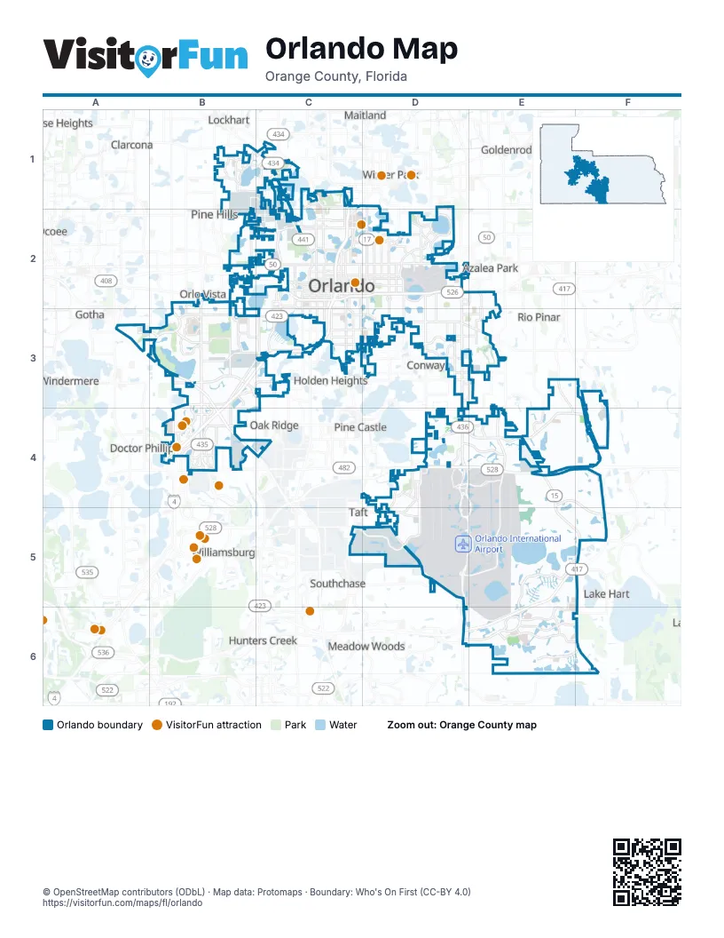
Street index of Orlando
Each street on the sheet and the grid squares it crosses.
- Clarcona Ocoee RoadB1
- All American BoulevardC1
- Edgewater DriveC1, C2
- I-4 ExpressC1, C2, B3, C3, B4
- John Young ParkwayC1, C2, C3, C4
- Lee RoadC1
- Maury RoadC1, C2
- North Orange Blossom TrailC1, C2
- North Mills AvenueD1, D2
- Orlando AvenueD1
- Kirkman RoadB2, B3, B4
- Old Winter Garden RoadB2
- Ortman DriveB2
- Princeton StreetB2, C2
- South Kirkman RoadB2, B3
- West Colonial DriveB2, C2
- Carter StreetC2
- East Anderson StreetC2, D2
- East Colonial DriveC2, D2
- East Princeton StreetC2, D2
- East Robinson StreetC2, D2
- East South StreetC2, D2
- East-West ExpresswayC2, D2
- Long StreetC2
- North Garland AvenueC2
- North Hughey AvenueC2
- North Magnolia AvenueC2
- North Orange AvenueC2
- North Rosalind AvenueC2
- Silver Star RoadC2
- Smith StreetC2
- South Ivanhoe BoulevardC2
- South Orange AvenueC2, C3, C5
- South Orange Blossom TrailC2, C3
- South Rosalind AvenueC2
- West Anderson StreetC2
- West Gore StreetC2
- West Robinson StreetC2
- West South StreetC2
- West Washington StreetC2
- Conway RoadD2, D3, D4
- Lake Underhill RoadD2, E2
- Maguire BoulevardD2
- Mills AvenueD2
- North Crystal Lake DriveD2
- Semoran BoulevardD2, D3, D4
- South Crystal Lake DriveD2
- South StreetD2
- Yucatan DriveE2
- Apopka Vineland RoadA3
- Florida's TurnpikeA3, B3, B4
- Conroy RoadB3, C3
- Vineland RoadB3, B4
- Americana BoulevardC3
- Michigan StreetC3
- Curry Ford RoadD3, E3
- International DriveB4
- Turkey Lake RoadB4
- Universal BoulevardB4
- West Sand Lake RoadB4
- Beachline ExpresswayD4, E4
- Boggy Creek RoadD4, D5, D6, E6, F6
- Tradeport DriveD4, D5
- Goldenrod RoadE4
- Hoffner AvenueE4
- Narcoossee RoadE4, E5, F5, F6
- South Goldenrod RoadE4
- Central Florida GreeneWayE5, D6, E6
- Lake Nona BoulevardE5, F5, D6, E6
- South Access RoadD6
Things to do on the Orlando map
Places on the map
- 33rd Street Industrial Park
- Abingdon Hill
- AdventHealth Medical Group - South Street
- AdventHealth Orlando
- Airport International Park of Orlando
- Airport Lakes
- Airside 4
- Albert Shores
- Ardmore Terrace
- Ardsley Manor
- Ashbury Park
- Ashley Place
- Aspire Health Partners- Princeton
- Autumn Green Village
- Avalon Condominiums
- Baldwin Park Trail
- Bardmoor
- Bel Air Hills
- Bel Air Manor
- Bel Air Shores
- Bella Vista at Tivoli Woods
- Bella Vita Apartments
- Bellanova at Jubilee Park
- Belle Isle Apartments
- Bert Martin's Champions for Children Emergency Department & Trauma Center
- Beverly Shores
- Bill Frederick Park at Turkey Lake
- Blue Jacket Memorial Park
- Brandy Harbor
- Brittany of Rosemont
- Brookhaven Apartments
- Buck Lake
- Bunche Manor
- Cady Way Trail
- Calvary Assembly
- Camden Reserve
- Candlewyck Village
- Center of Commerce at Orlando
- Central Florida Fairgrounds
- Charter Lake
Next to Orlando
- Alafaya
- Azalea Park
- Bay Hill
- Clarcona
- Conway
- Doctor Phillips
- Fairview Shores
- Goldenrod
- Gotha
- Holden Heights
- Hunters Creek
- Lake Hart
- Lockhart
- Maitland
- Marydia
- Meadow Woods
- Oak Ridge
- Ocoee
- Paradise Heights
- Pine Castle
- Pine Hills
- Rio Pinar
- Southchase
- Taft
- Tangelo Park
- Union Park
- University
- Williamsburg
- Windermere
- Winter Park
© OpenStreetMap contributors (ODbL) · Map data: Protomaps · Boundary: Who's On First (CC-BY 4.0)