

Florida map
Royal Palm Beach map
About 41,948 people live here (Census Bureau, 2024 estimate). The sheet's index lists 300 streets; Crestwood Boulevard, Royal Palm Beach Boulevard and Sparrow Drive cross the most grid squares. Also on it: Commons Park, Madison Green Golf Club and Royal Pines Natural Area.
Open the map (PDF, US Letter)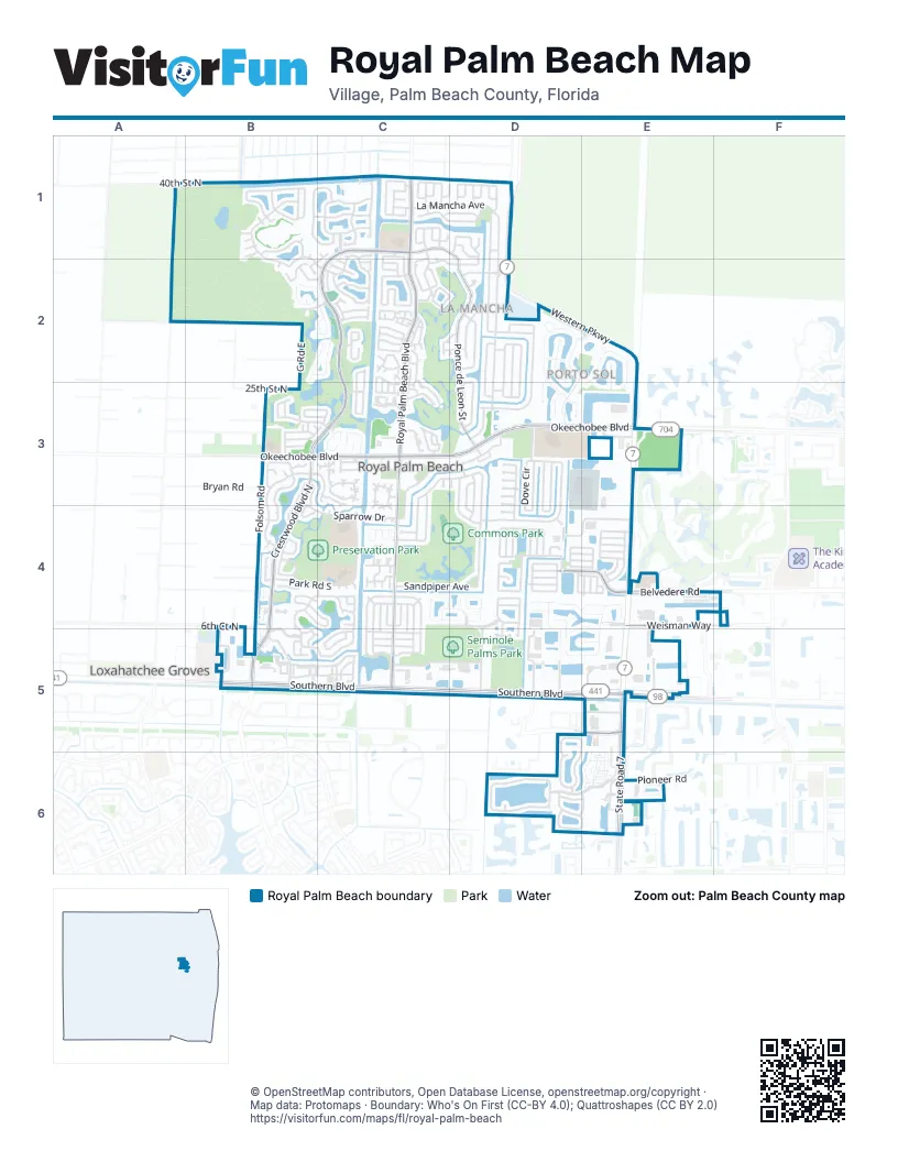
Street index of Royal Palm Beach
Each street on the sheet and the grid squares it crosses.
- Southern BoulevardB5, C5, D5, E5
- Okeechobee BoulevardB3, C3, D3, E3
- Belvedere RoadD4, E4
- State Road 7E5, E6
- Crestwood BoulevardC1, C2, B3, C3, B4, B5
- Crestwood Boulevard NorthB3, B4
- Forest Hill BoulevardB5
- Royal Palm Beach BoulevardC1, C2, C3, C4, C5
- Ponce de Leon StreetC1, D1, D2, D3
- Folsom RoadB3, B4, B5
- Western ParkwayD1, D2, E2, E3
- Erica BoulevardE5
- Weisman WayE4, F4
- Tuttle BoulevardD5
- Bellarosa CircleD2, E2, D3, E3
- Sandpiper AvenueC3, D3, C4, D4
- Shoma DriveE6
- La Mancha AvenueC1, D1, D2, D3
- Las Palmas StreetD1, D2
- Sparrow DriveB3, C3, D3, B4, C4
- Cypress TraceB4, C4, B5, C5
- Berenger WalkD6
- Bobwhite RoadD3, D4
- Bilbao StreetD2, D3
- Saratoga Boulevard WestB1, B2, C2
- Saratoga Boulevard EastC1, C2
- Portosol AvenueD2, E2, D3
- Monterey WayB1
- Victoria Grove BendD6, E6
- Kensington WayD5, E5, D6, E6
- Crestwood CircleB4, B5
- Cordoba CircleD2, D3
- Reston CircleC2, C3
- Bella Vista WayD4, E4, D5, E5
- Kings WayB3, B4
- Santa Monica AvenueD1, C2, D2
- Hibiscus DriveC4, C5
- Lamstein LaneC4, D4, D5
- Oakwater DriveC3
- Streng LaneB1, C1
- Ridgewood CircleB2, C2
- Camellia DriveC4, C5
- Martin CircleD3, D4
- Dove CircleD3, D4
- Seminole Lake DriveC4, D4
- Sunflower CircleC1
- Grandview CircleD4
- 40th Street NorthA1, B1, C1
- Civic Center WayC3
- Sweet Bay LaneB4, C4
- Sevilla AvenueC1, C2
- Par DriveC2
- Park Road SouthB4, C4
- Business Park WayD4, E4
- Miramar AvenueC1, C2
- Crestwood Court NorthB5
- Parkwood DriveC2
- Grandview WayD4
- Cypress Lave AvenueB5
- Heatherwood DriveC2, C3
- Bryan RoadB3
- Catania WayD4, E4
- Meadowlark DriveC3, C4
- Misty Oaks CircleB2, C2
- Santiago StreetD2
- Weybridge CircleC3, C4
- 103rd Avenue NorthD5
- Seminole Palms DriveC5, D5
- Crestwood Court SouthB5
- Orchid DriveC4, C5
- 6th Court NorthB4
- Fernwood CrescentC5
- Annandale CircleB3, C3
- Rivera AvenueC1, D1
- Granada StreetD2, D3
- Gardenia DriveC4, C5
- Briar Oak DriveB3
- Park Road NorthC4
- Waterway RoadB3, B4
- Viscaya AvenueC1
- Valencia StreetC1
- Indian Head CircleC3
- Waldorf DriveB3, C3
- Parkwood Drive SouthC2
- River Bluff LaneD4
- G Road EastB2, B3
- Chorus WayE4
- Elysium DriveC2, D2
- Brinely PlaceC1
- Haldin PlaceC1
- Pioneer RoadE6
- Pioneer WayE6
- Kapok CrescentB4, C4
- Galiano StreetD3
- Strathmore Gate DriveC3, C4
- Country Club DriveC2, C3
- Lexington DriveB1
- Queens LaneB3
- Heron ParkwayD3, D4
- Bella Terra WayE4
- Whitcombe DriveB1, C1
- Sherwood DriveC1, C2
- Bellezza TerraceE4
- Vicara CourtD2, D3
- Starling AvenueD3, D4
- Oleander DriveC5
- Canterbury LaneD6, E6
- Cortes AvenueD2, D3
- Dunning DriveC1
- Bellcrest CircleC2
- Cocoplum LaneB4
- Roy Court CircleC2
- Van Gogh WayB3, B4
- Alcazar StreetD2
- Preserve DriveB3, C3
- Lakeview CircleC3
- Palms West DriveB5
- Swan Parkway EastD3, D4
- Palm Beach Trace DriveC3
- Cypress Key WayB5, C5
- Arbor LaneB2, C2
- Prestige DriveC2, C3
- Cape Ivy PtD4
- Park CentralB5, C5
- Greenway Circle SouthC4
- Dalmany WayD4
- Chestnut CircleB4
- Garden Cypress TrailD4
- Running Oak LaneB3, C3
- River Run DriveC3
- Peppergrass RunD4, D5
- Regalo DriveD2, E2
- Balsam DriveC5
- Dahlia DriveC5
- Mayacoo Lakes BoulevardE4
- Adell AvenueC1
- Swan Parkway WestD3, D4
- Lakeview Drive EastC3
- Derby LaneC2
- Hamilton TerraceD6
- Madrid StreetD2
- Christina DriveE6
- Poinciana BoulevardC4
- Barcelona DriveD3
- Salzedo StreetC1, D1
- Pine RoadB2, C2
- Ridgefield DriveC3
- Fontana LaneB2, C2
- Westmont DriveC2
- Wild Cat WayD3
- Black Olive CrescentB4
- Fox Trail Road SouthE3
- Tuscany DriveD4, E4, D5, E5
- Spanish Pine TerraceC2
- West Greenway DriveC4
- 95th Avenue NorthE5
- Acme RoadE5
- Sunshine BoulevardC2
- Pepper Tree CrescentC4
- 25th Street NorthB3
- 105th Avenue NorthD5
- Nottingham RoadB4
- Santa Cruz AvenueC1
- Casey RoadB4
- Village Walk DriveC4
- Gibraltar StreetD1
- Cypress CrescentB5
- Natures WayB1
- Bellcrest CourtC2
- Venetian LaneB1
- Belcara CourtD3
- Indian Trail DriveC2
- Cypress Head AvenueC5
- Mikado LaneE4
- Morgate CircleB4
- Azalea DriveC4, C5
- Summertime LaneD4
- Carissa DriveC4, C5
- Strada CourtE2, E3
- Denlow LaneD4
- Thornridge LaneD4
- Arterra CourtD2, D3
- Lilac DriveC4
- Croton DriveC4
- Bauer RoadC1
- McDermott LaneD4
- Moonlight WayD4
- Royal Pine Circle EastC2
- Silk Carnation WayD5
- Stardust WayD4
- Sycamore DriveB4
- Cambridge LaneB3, B4
- Silver Bell CresentB5
- Ramblewood CircleC4
- Westmont LaneC2
- Savoyard WayE4
- Preserve CourtC3
- Ryan LaneD4
- Thornbank LaneD4
- Meadow Woode DriveC5
- Donwoods LaneD4
- Raven CourtD3
- Sarona CircleD4
- Brook Woode AvenueC5
- Pienza CircleD2
- Sunflower StreetC1
- Westecunk DriveC2
- Rainbow Springs TerraceD4
- Bobbie LaneD4
- Fascination LaneD4
- Cortile StreetD2
- Natchez Trace AvenueC2, D2
- Newberry LaneD6, E6
- Meadowlands DriveC2
- Patience LaneE4
- Pinafore LaneE4
- Yeoman LaneE4
- Misty LaneD4
- Stamford AvenueC2
- Lancaster WayD6, E6
- Seminole Lakes DriveD4
- Carousel WayE4
- Penzance LaneE4
- Aquarius LaneD4
- 120th Avenue NorthC1
- Waterview WayC5
- Sand Pine WayC2
- Bobwhite CourtD4
- Cocoplum CircleB4
- Infanta AvenueC2, D2
- Carmen LaneD4, E4
- Oliver LaneD4, E4
- Grand Duke WayE4
- Klays CourtC1
- Royal Pine Circle WestC2
- Pippin LaneD4, E4
- Meander CircleC4
- Sage Meadow TerraceD4
- Showboat LaneD4, E4
- Westwood Circle WestE6
- Blue Violet LaneD4
- Harmony WayD4
- Gembrook CourtC3
- Elmbank WayD4
- Royal Pine Circle SouthC2
- Prado StreetD1
- Sunshine RoadE5
- Grand Oaks BoulevardB3, C3
- Isleworth CourtC3
- Toledo StreetC1
- Rhapsody WayE4
- Malaga StreetD1
- Copperwood CircleC4
- Segura StreetD1
- Santander CourtC1, D1
- Rockville LaneC2
- Fontana PlaceB2
- Almeria StreetD1
- Twin Lakes WayB1
- Camellia Park DriveC5
- Segovia AvenueC1
- Fairway LaneC2, C3
- Fox Trail Road NorthE3
- Isola CircleD5, E5
- Balboa BoulevardD3
- Cayo Costa CourtC4, D4
- Serenade LaneD4, E4
- Westside WayD4
- Windwood WayC2
- Symphony LaneD4, E4
- Glendale DriveC2
- Fiddle Wood CourtB3
- Greenway Village NorthC4
- Serenade CircleE4
- Venice BoulevardD4
- Hemingway CourtB3
- Mimosa StreetC1
- Paseo CourtD2
- Grouse LaneD4
- Bella Vista DriveC3
- Mangrove CourtB5
- Sonata WayE4
- Conaskonk CircleC2
- Concert WayE4
- Road CC4
- Royal Pine Circle NorthC2
- Gulfstream CircleB2
- Mill Pond LaneC5
- Eider CourtD3
- Waldorf StreetB3
- Finch CourtD3
- Puffin CourtD3
- Seagull CourtD3
- Jay CourtD4
- Churchill DriveC1, B2
- Belmont DriveC1
- Bent OakC3
- Teal CourtD3
- Country Club WayC2
- Wakulla Springs WayD4
Places on the map
- ALDI
- AutoZone
- Brass Ring Pub
- Bru's Room Grill and Bar
- Camellia Park
- Carrabba's Italian Grill
- Christ Fellowship - Royal Palm Campus
- Civic Center
- Civic Center Way
- Commons Park
- Costco
- Crestwood Community Middle School
- Crestwood Square
- Cypress Trails Elem Drive
- Cypress Trails Elementary School
- Fortunoffs Backyard Store
- Goodyear Auto Service Center
- H L Johnson Community Elementary School
- H L Johnson Trail
- HomeGoods
- Katz Fields
- Lake Challenger
- Lakeside Challenger Park and Memorial
- Lindsay Ewing Park
- Madison Green Golf Club
- Madison Park
- MD Now
- Our Lady Queen of Peace Cemetery
- Our Lady Queen Of The Apostles
- Outback Steakhouse
- Palm Beach County Public Library - Okeechobee Boulevard Branch
- Preservation Park
- Royal Palm Beach Branch
- Royal Palm Beach High School
- Royal Pines Natural Area
- Seminole Palms Park
- Southern Palm Crossing
- The UPS Store
- Village Golf Club
- Willows Baseball Park
Next to Royal Palm Beach
- Loxahatchee Groves
© OpenStreetMap contributors, Open Database License, openstreetmap.org/copyright · Map data: Protomaps · Boundary: Who's On First (CC-BY 4.0); Quattroshapes (CC BY 2.0)















