

Florida map
West Park map
About 15,641 people live here (Census Bureau, 2024 estimate). The sheet's index lists 101 streets; Southwest 54th Avenue, South State Road 7 and Southwest 18th Street cross the most grid squares. Also on it: Mctyre Park, Carver Ranches Branch Library and Corver Ranches Recreation Center.
Open the map (PDF, US Letter)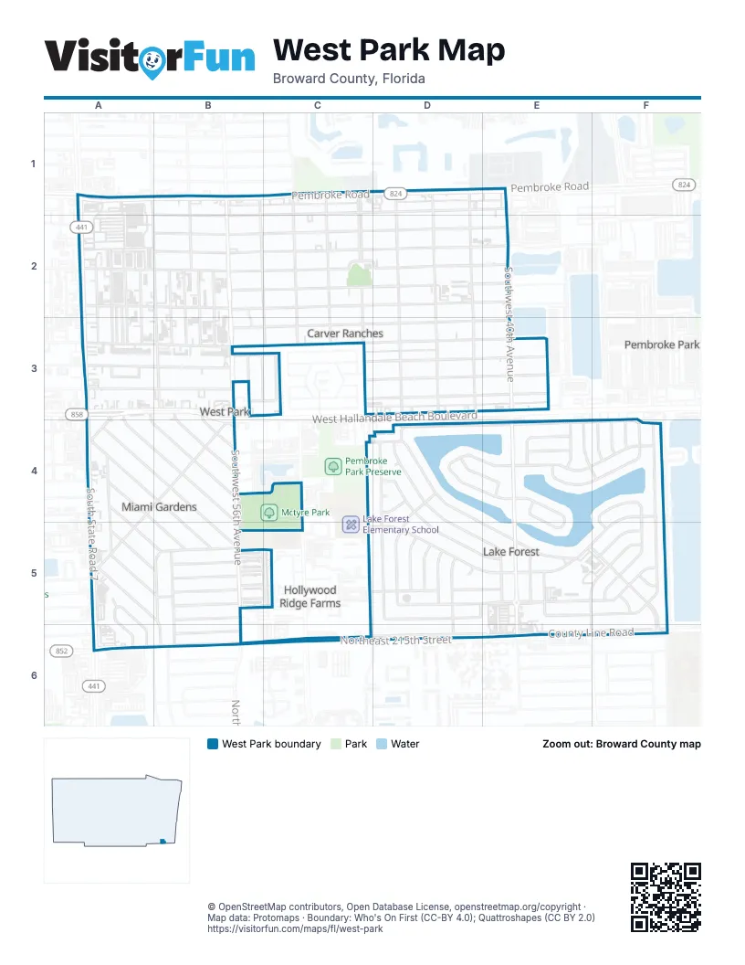
Street index of West Park
Each street on the sheet and the grid squares it crosses.
- Pembroke RoadA1, B1, C1, D1, E1
- South State Road 7A1, A2, A3, A4, A5, A6
- Southwest 18th StreetA1, B1, C1, D1, E1, B2
- Southwest 58th AvenueA1, A2, B2, B3, B5, B6
- West Pembroke RoadA1, B1
- Southwest 54th AvenueB1, B2, C2, B3, C3, C4, B5, C5
- Southwest 56th AvenueB1, B2, B3, B4, B5, B6
- Southwest 57th AvenueB1, B2
- South 52nd AvenueC1
- Southwest 48th AvenueC1, C2, C3, C5
- Southwest 50th AvenueC1, C2, C3
- Southwest 52nd AvenueC1, C2, C3, C4, C5
- Myrtle Oak TerraceD1
- Southwest 42nd AvenueD1, D2, D3, D5
- Southwest 44th AvenueD1, D2, D3, D5
- Southwest 46th AvenueD1, D2, D3, D4, D5
- Southwest 40th AvenueE1, E2, E3, E4, E5, E6
- Bluebird AvenueA2, A3
- Redbird AvenueA2, A3
- S.W. 23rd St.A2, B2
- Southwest 19th StreetA2, B2, C2, D2, E2
- Southwest 23rd StreetA2, B2, C2, D2, E2
- Southwest 58th TerraceA2, A3, B5, B6
- Southwest 58th WayA2, A3
- Southwest 59th AvenueA2, A3, A5, A6
- Southwest 59th TerraceA2, A3, A4, A5, A6
- Southwest 20th StreetB2, C2, D2, E2
- Southwest 21st StreetB2, C2, D2, E2
- Southwest 22nd StreetB2, C2, D2, E2
- Southwest 56th TerraceB2, B3
- Southwest 57th TerraceB2, B3
- Southwest 57th WayB2, B3
- Allen RoadA3, A4, B4
- Barry RoadA3, A4
- Edmund RoadA3, A4, B4, B5
- Southwest 25th StreetA3, B3, C3, D3, E3
- Southwest 26th StreetA3, B3, C3, D3, E3
- Southwest 26th TerraceA3
- Southwest 27th StreetA3, B3, D3, E3
- West Hallandale Beach BoulevardA3, B3, B4
- Marion RoadB3, B4
- Southwest 24th StreetB3, C3, D3, E3
- Southwest 25th CourtB3, C3
- Southwest 28th StreetB3, C3, D3, E3
- Southwest 55th AvenueB3
- William RoadB3, B4
- Southwest 53rd AvenueC3
- Southwest 38th AvenueE3, E5
- Miami Gardens RoadA4, B4, B5
- Ronald RoadA4, B4, B5
- Sutton RoadA4, B4, A5
- Thomas RoadA4, A5, B5
- Virginia RoadA4, B5
- Southwest 32nd CourtB4, D4, E4, F4
- Southwest 34th StreetB4, C4
- Southwest 33rd StreetC4, D4, E4, E5
- Southwest 30th StreetD4, E4, F4
- Southwest 31st DriveD4, D5, E5
- Southwest 32nd DriveD4, D5, E5
- Southwest 32nd StreetD4, E4, F4
- Southwest 33rd DriveD4, D5, E5
- Southwest 35th StreetD4, F4, F5
- Southwest 47th AvenueD4, D5
- Southwest 31st CourtE4
- Southwest 31st StreetE4
- Southwest 33rd CourtE4, E5
- Southwest 37th AvenueE4, F4, E5, F5, F6
- Southwest 37th TerraceE4
- Southwest 39th AvenueE4, E5
- Southwest 32nd AvenueF4, F5
- Southwest 33rd AvenueF4, F5
- Southwest 34th AvenueF4, F5
- Southwest 35th AvenueF4
- Southwest 36th AvenueF4
- Southwest 36th StreetF4, B5, D5, E5, F5
- Clifton RoadA5, B5
- Harvard RoadA5, B5
- Newton RoadA5, B5
- Southwest 36th CourtB5, F5
- Southwest 37th StreetB5, C5, E5, F5
- Southwest 38th CourtB5, C5
- Southwest 38th StreetB5, C5, D5, E5, F5
- Southwest 39th StreetB5, D5, E5, F5
- Southwest 40th StreetB5, D5, E5, F5
- Southwest 43rd AvenueD5
- Southwest 45th AvenueD5
- Southwest 45th TerraceD5
- Southwest 32nd BoulevardE5, F5, F6
- Southwest 41st AvenueE5
- Southwest 39th CourtF5
- Northwest 215th StreetA6, B6
- Northwest Miami CourtA6
- North Miami AvenueB6
- Northeast 215th StreetB6, C6, D6, E6
- Northeast 2nd AvenueB6
- Southwest 40th CourtB6
- Southwest 41st StreetC6, D6, E6, F6
- Northeast 8th CourtD6
- County Line RoadE6, F6
- Northeast 10th AvenueE6
- Northeast 12th AvenueF6
Places on the map
- Annunciation Church
- Annunciation School
- Atlantis Private School
- Burger King
- Carver Ranches Branch Library
- Carver Ranches Center
- Carver Ranches Fire Department Station 17
- Corver Ranches Recreation Center
- Dollar Tree
- Florida Restoration Consultants & Estimators
- Lake Forest Fire Department Station 48
- Madonna Academy
- Mctyre Park
- Miami Subs Grill
- Mirawood Day School
- Rice N' Wings
- Southwest 40th Avenue
- The Home Depot
Next to West Park
- Hollywood Ridge Farms
- Pembroke Park
© OpenStreetMap contributors, Open Database License, openstreetmap.org/copyright · Map data: Protomaps · Boundary: Who's On First (CC-BY 4.0); Quattroshapes (CC BY 2.0)















